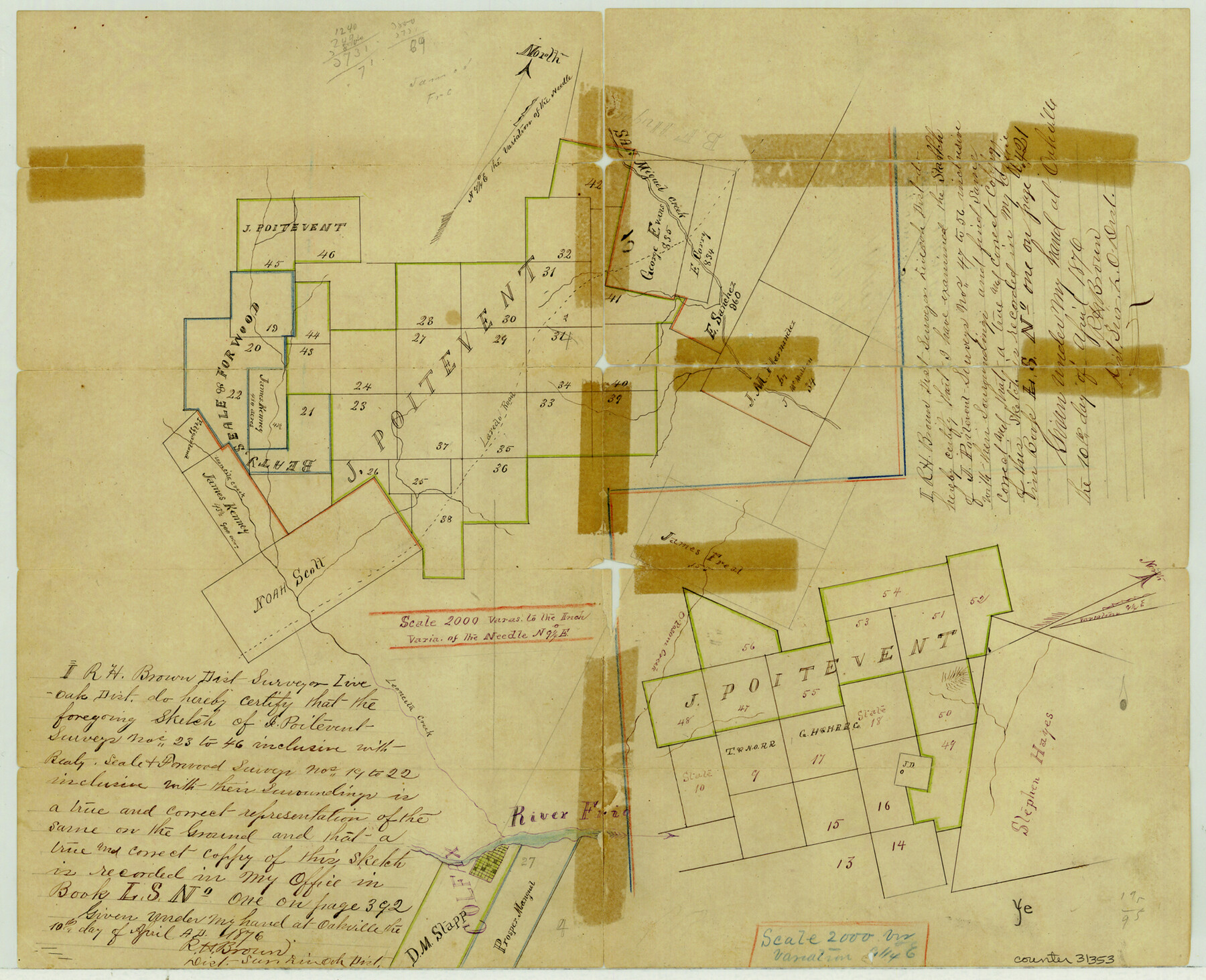
McMullen County Sketch File 10
[Separate sketches in northwest and northeast parts of county]
-
Map/Doc
31353
-
Collection
General Map Collection
-
Object Dates
1876/4/10 (Creation Date)
1876/5/8 (File Date)
-
People and Organizations
R.H. Brown (Surveyor/Engineer)
-
Counties
McMullen Atascosa Live Oak
-
Subjects
Surveying Sketch File
-
Height x Width
14.3 x 17.6 inches
36.3 x 44.7 cm
-
Medium
paper, manuscript
-
Features
San Miguel Creek
Laredo Road
Leoneita Creek
O'Posom [sic] Creek
River Frio
Colfax
Part of: General Map Collection
Kimble County Working Sketch 29

Print $20.00
- Digital $50.00
Kimble County Working Sketch 29
1941
Size 24.7 x 15.3 inches
Map/Doc 70097
Hemphill County Working Sketch Graphic Index - sheet 2

Print $20.00
- Digital $50.00
Hemphill County Working Sketch Graphic Index - sheet 2
1899
Size 40.2 x 38.2 inches
Map/Doc 76575

Atascosa County Working Sketch 30

Print $20.00
- Digital $50.00
Atascosa County Working Sketch 30
1980
Size 16.4 x 20.6 inches
Map/Doc 67226
Brewster County Sketch File 48

Print $4.00
- Digital $50.00
Brewster County Sketch File 48
1940
Size 11.4 x 9.2 inches
Map/Doc 16327
Anderson County Working Sketch 8

Print $20.00
- Digital $50.00
Anderson County Working Sketch 8
1923
Size 18.6 x 20.6 inches
Map/Doc 67007
Kleberg County

Print $20.00
- Digital $50.00
Kleberg County
1913
Size 26.7 x 32.8 inches
Map/Doc 66894
Dimmit County Working Sketch 44

Print $20.00
- Digital $50.00
Dimmit County Working Sketch 44
1979
Size 31.7 x 34.0 inches
Map/Doc 68705
Jefferson County NRC Article 33.136 Sketch 12

Print $22.00
- Digital $50.00
Jefferson County NRC Article 33.136 Sketch 12
2017
Size 24.0 x 36.0 inches
Map/Doc 95055
Flight Mission No. DCL-7C, Frame 96, Kenedy County

Print $20.00
- Digital $50.00
Flight Mission No. DCL-7C, Frame 96, Kenedy County
1943
Size 15.4 x 15.2 inches
Map/Doc 86068
Platt [sic] of Late Surveys on Carancahua, Jackson County
![78360, Platt [sic] of Late Surveys on Carancahua, Jackson County, General Map Collection](https://historictexasmaps.com/wmedia_w700/maps/78360.tif.jpg)
Print $2.00
- Digital $50.00
Platt [sic] of Late Surveys on Carancahua, Jackson County
Size 10.9 x 8.0 inches
Map/Doc 78360
Wise County Rolled Sketch 4

Print $20.00
- Digital $50.00
Wise County Rolled Sketch 4
1955
Size 20.0 x 13.7 inches
Map/Doc 8278
You may also like
Terre Nove (verso)

Print $20.00
- Digital $50.00
Terre Nove (verso)
1522
Size 12.2 x 7.8 inches
Map/Doc 93802
Stonewall County

Print $20.00
- Digital $50.00
Stonewall County
1902
Size 39.6 x 38.5 inches
Map/Doc 63049
Pecos County Sketch File 92

Print $4.00
- Digital $50.00
Pecos County Sketch File 92
1954
Size 11.2 x 8.6 inches
Map/Doc 33988

Flight Mission No. DAG-24K, Frame 41, Matagorda County

Print $20.00
- Digital $50.00
Flight Mission No. DAG-24K, Frame 41, Matagorda County
1953
Size 18.5 x 22.4 inches
Map/Doc 86528
Potter County Boundary File 5b

Print $22.00
- Digital $50.00
Potter County Boundary File 5b
Size 4.1 x 4.9 inches
Map/Doc 58025
The Judicial District/County of Hamilton. Created, February 2, 1842

Print $20.00
The Judicial District/County of Hamilton. Created, February 2, 1842
2020
Size 14.9 x 21.7 inches
Map/Doc 96329

Hopkins County Sketch File 8

Print $6.00
- Digital $50.00
Hopkins County Sketch File 8
1856
Size 11.8 x 8.6 inches
Map/Doc 26695
No. 3 Chart of Channel connecting Corpus Christi Bay with Aransas Bay, Texas

Print $20.00
- Digital $50.00
No. 3 Chart of Channel connecting Corpus Christi Bay with Aransas Bay, Texas
1878
Size 18.3 x 27.9 inches
Map/Doc 72783
Coke County Rolled Sketch 8

Print $20.00
- Digital $50.00
Coke County Rolled Sketch 8
Size 26.5 x 34.8 inches
Map/Doc 5507
Outer Continental Shelf Leasing Maps (Louisiana Offshore Operations)

Print $20.00
- Digital $50.00
Outer Continental Shelf Leasing Maps (Louisiana Offshore Operations)
1954
Size 18.2 x 16.0 inches
Map/Doc 76105