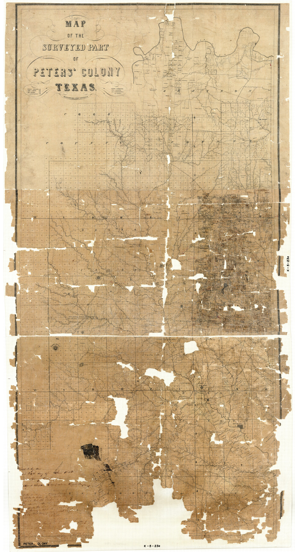
Map of The Surveyed Part of Peters Colony Texas
K-5-23a
-
Map/Doc
1964
-
Collection
General Map Collection
-
Object Dates
1852 (Creation Date)
-
People and Organizations
Milne and Bruder Lithographers (Printer)
Henry O. Hedgcoxe (Author)
-
Subjects
Colony
-
Height x Width
53.0 x 28.1 inches
134.6 x 71.4 cm
-
Comments
Certified on June 24, 1852 by Henry O. Hedgcoxe, Agent of the Texas Emigration Land Company.
Includes parts of Collin, Cooke, Dallas, Denton, Grayson, and Tarrant Counties. Adopted by Louise Herfel in honor of her husband Timothy David Herfel.
Part of: General Map Collection
[Surveys in McMullen and McGloin's Colony along the San Antonio River]
![30, [Surveys in McMullen and McGloin's Colony along the San Antonio River], General Map Collection](https://historictexasmaps.com/wmedia_w700/maps/30-1.tif.jpg)
Print $20.00
- Digital $50.00
[Surveys in McMullen and McGloin's Colony along the San Antonio River]
1828
Size 19.3 x 24.5 inches
Map/Doc 30
Galveston County Rolled Sketch 44

Print $20.00
- Digital $50.00
Galveston County Rolled Sketch 44
1991
Size 24.9 x 36.9 inches
Map/Doc 5973
America's Fun-Tier: Texas 1967 Official State Highway Map

Digital $50.00
America's Fun-Tier: Texas 1967 Official State Highway Map
Size 28.3 x 36.6 inches
Map/Doc 94322
Shackelford County Sketch File 3

Print $8.00
- Digital $50.00
Shackelford County Sketch File 3
1852
Size 8.2 x 7.3 inches
Map/Doc 36574
Palo Pinto County Sketch File 29

Print $40.00
- Digital $50.00
Palo Pinto County Sketch File 29
1874
Size 12.8 x 16.0 inches
Map/Doc 33419
Real County Working Sketch 74

Print $20.00
- Digital $50.00
Real County Working Sketch 74
1979
Size 17.1 x 23.5 inches
Map/Doc 71966
Flight Mission No. BRA-7M, Frame 151, Jefferson County

Print $20.00
- Digital $50.00
Flight Mission No. BRA-7M, Frame 151, Jefferson County
1953
Size 18.7 x 22.6 inches
Map/Doc 85545
Irion County Working Sketch 1

Print $20.00
- Digital $50.00
Irion County Working Sketch 1
Size 24.3 x 26.8 inches
Map/Doc 66410
Lynn County Rolled Sketch W

Print $20.00
- Digital $50.00
Lynn County Rolled Sketch W
Size 23.0 x 40.0 inches
Map/Doc 6655
Red River County Sketch File 9

Print $10.00
- Digital $50.00
Red River County Sketch File 9
1862
Size 12.6 x 8.2 inches
Map/Doc 35117

Flight Mission No. BRE-2P, Frame 15, Nueces County

Print $20.00
- Digital $50.00
Flight Mission No. BRE-2P, Frame 15, Nueces County
1956
Size 18.4 x 22.4 inches
Map/Doc 86724
You may also like
Bowie County Working Sketch 25

Print $20.00
- Digital $50.00
Bowie County Working Sketch 25
1977
Size 20.5 x 33.9 inches
Map/Doc 67429
No. 3 Chart of Channel connecting Corpus Christi Bay with Aransas Bay, Texas

Print $20.00
- Digital $50.00
No. 3 Chart of Channel connecting Corpus Christi Bay with Aransas Bay, Texas
1878
Size 18.2 x 28.0 inches
Map/Doc 72772
Cameron County Sketch File 16

Print $18.00
- Digital $50.00
Cameron County Sketch File 16
1998
Size 11.2 x 8.6 inches
Map/Doc 76334
Edwards County Rolled Sketch 25

Print $20.00
- Digital $50.00
Edwards County Rolled Sketch 25
1955
Size 30.2 x 35.5 inches
Map/Doc 5811
Pecos County Rolled Sketch 181

Print $20.00
- Digital $50.00
Pecos County Rolled Sketch 181
1980
Size 18.4 x 18.7 inches
Map/Doc 7300
PSL Field Notes for Blocks 53 and 55 in Culberson and Reeves Counties and Blocks 42, 52, and 54 in Culberson County

PSL Field Notes for Blocks 53 and 55 in Culberson and Reeves Counties and Blocks 42, 52, and 54 in Culberson County
Map/Doc 81673
Fisher County Working Sketch 19

Print $20.00
- Digital $50.00
Fisher County Working Sketch 19
1962
Size 26.2 x 25.5 inches
Map/Doc 69153
Flight Mission No. DQN-1K, Frame 130, Calhoun County

Print $20.00
- Digital $50.00
Flight Mission No. DQN-1K, Frame 130, Calhoun County
1953
Size 18.5 x 22.1 inches
Map/Doc 84193
Northeast Part Presidio County

Print $20.00
- Digital $50.00
Northeast Part Presidio County
1973
Size 41.3 x 32.4 inches
Map/Doc 73265
Duval County Working Sketch 49

Print $40.00
- Digital $50.00
Duval County Working Sketch 49
1981
Size 37.0 x 81.3 inches
Map/Doc 68773
Harrison County Working Sketch 5

Print $20.00
- Digital $50.00
Harrison County Working Sketch 5
1953
Size 39.7 x 39.8 inches
Map/Doc 66025
Williamson County Working Sketch 9

Print $20.00
- Digital $50.00
Williamson County Working Sketch 9
1954
Size 31.2 x 30.0 inches
Map/Doc 72569