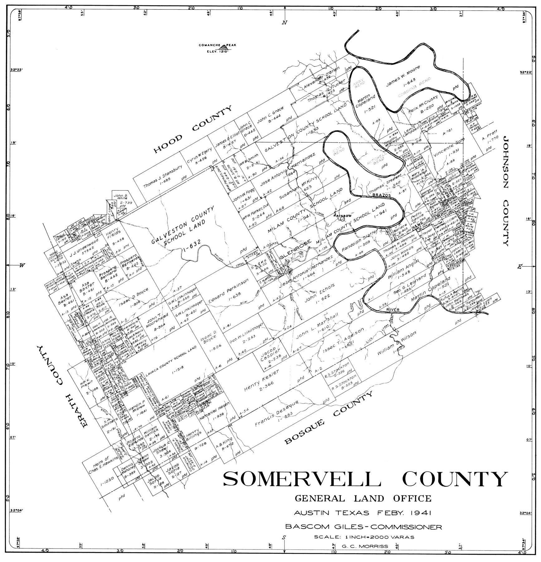
Somervell County
-
Map/Doc
77424
-
Collection
General Map Collection
-
Object Dates
1941 (Creation Date)
-
People and Organizations
Eltea Armstrong (Draftsman)
G.C. Morriss (Compiler)
-
Counties
Somervell
-
Subjects
County
-
Height x Width
25.1 x 24.1 inches
63.8 x 61.2 cm
Part of: General Map Collection
Flight Mission No. DQN-2K, Frame 69, Calhoun County

Print $20.00
- Digital $50.00
Flight Mission No. DQN-2K, Frame 69, Calhoun County
1953
Size 16.2 x 16.1 inches
Map/Doc 84261
Navarro County Working Sketch 8

Print $20.00
- Digital $50.00
Navarro County Working Sketch 8
1955
Size 17.9 x 19.2 inches
Map/Doc 71238

Texas 1971 Official State Highway Map

Digital $50.00
Texas 1971 Official State Highway Map
Size 28.3 x 36.5 inches
Map/Doc 94316
Travis County Boundary File 4a

Print $40.00
- Digital $50.00
Travis County Boundary File 4a
Size 27.9 x 17.8 inches
Map/Doc 59428
San Patricio County Sketch File 17

Print $20.00
San Patricio County Sketch File 17
1873
Size 12.0 x 19.0 inches
Map/Doc 12284
Crosby County Sketch File 11a

Print $10.00
- Digital $50.00
Crosby County Sketch File 11a
1894
Size 8.7 x 4.4 inches
Map/Doc 20029
Right of Way and Track Map of The Missouri, Kansas & Texas Railway of Texas

Print $40.00
- Digital $50.00
Right of Way and Track Map of The Missouri, Kansas & Texas Railway of Texas
1918
Size 25.7 x 107.8 inches
Map/Doc 64532
Matagorda County Sketch File 23

Print $4.00
- Digital $50.00
Matagorda County Sketch File 23
1898
Size 14.2 x 8.6 inches
Map/Doc 30785
Right-of-Way & Track Map, Houston and Brazos Valley Ry. Co. operated by the Houston and Brazos Valley Ry. Co.

Print $40.00
- Digital $50.00
Right-of-Way & Track Map, Houston and Brazos Valley Ry. Co. operated by the Houston and Brazos Valley Ry. Co.
1918
Size 25.0 x 55.7 inches
Map/Doc 64605
Galveston County Rolled Sketch S

Print $20.00
- Digital $50.00
Galveston County Rolled Sketch S
1935
Size 36.0 x 46.8 inches
Map/Doc 9088
Map of Webb County

Print $20.00
- Digital $50.00
Map of Webb County
1878
Size 37.0 x 26.0 inches
Map/Doc 4130
You may also like
Fayette County Working Sketch 1

Print $20.00
- Digital $50.00
Fayette County Working Sketch 1
1949
Size 25.4 x 18.0 inches
Map/Doc 69165
Harris County Rolled Sketch O

Print $20.00
- Digital $50.00
Harris County Rolled Sketch O
Size 19.3 x 28.9 inches
Map/Doc 6141
Val Verde County Rolled Sketch 77

Print $20.00
- Digital $50.00
Val Verde County Rolled Sketch 77
1981
Size 36.2 x 37.4 inches
Map/Doc 10087
Working Sketch in Stephens County

Print $20.00
- Digital $50.00
Working Sketch in Stephens County
1919
Size 15.4 x 18.6 inches
Map/Doc 91912
Flight Mission No. CRC-2R, Frame 60, Chambers County

Print $20.00
- Digital $50.00
Flight Mission No. CRC-2R, Frame 60, Chambers County
1956
Size 18.4 x 22.3 inches
Map/Doc 84731
General Highway Map, Ector County, Texas

Print $20.00
General Highway Map, Ector County, Texas
1940
Size 18.4 x 24.9 inches
Map/Doc 79081
C. C. S. D. & R. G. N. G. RR. Company, Block C2]
![90780, C. C. S. D. & R. G. N. G. RR. Company, Block C2], Twichell Survey Records](https://historictexasmaps.com/wmedia_w700/maps/90780-1.tif.jpg)
Print $20.00
- Digital $50.00
C. C. S. D. & R. G. N. G. RR. Company, Block C2]
Size 14.0 x 21.2 inches
Map/Doc 90780
Hidalgo County Sketch File 9

Print $40.00
- Digital $50.00
Hidalgo County Sketch File 9
1904
Size 8.8 x 5.7 inches
Map/Doc 26409
Morris County Rolled Sketch 2A

Print $20.00
- Digital $50.00
Morris County Rolled Sketch 2A
Size 24.0 x 18.7 inches
Map/Doc 10256
Mills County Boundary File 5b

Print $8.00
- Digital $50.00
Mills County Boundary File 5b
Size 14.2 x 8.7 inches
Map/Doc 57307
Jasper County Sketch File 26

Print $16.00
- Digital $50.00
Jasper County Sketch File 26
1944
Size 11.2 x 8.8 inches
Map/Doc 27834
Pecos County Working Sketch 32

Print $20.00
- Digital $50.00
Pecos County Working Sketch 32
1936
Size 21.8 x 22.2 inches
Map/Doc 71504