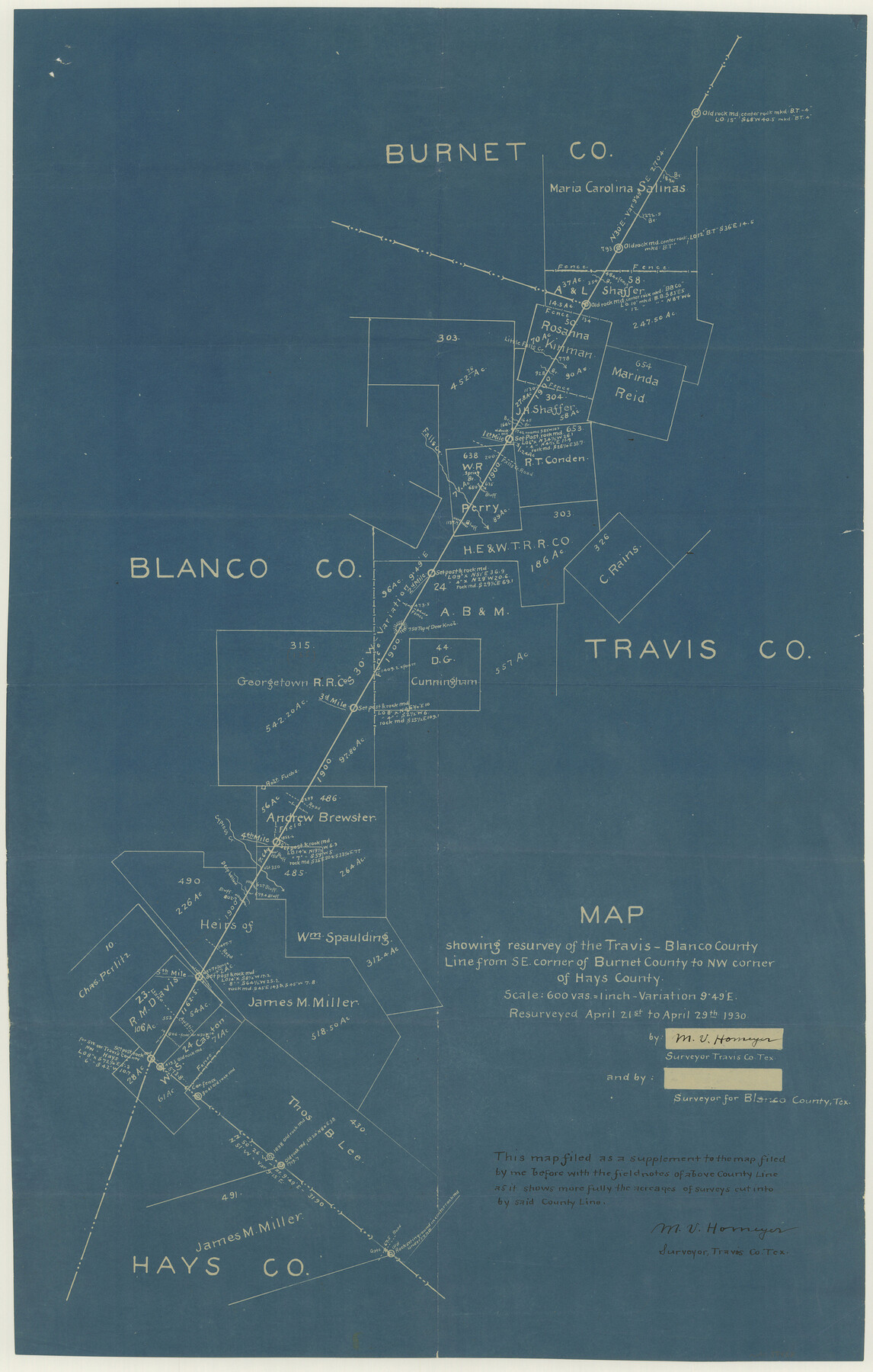
Travis County Boundary File 4a
Map showing resurvey of the Travis-Blanco County Line from SE corner of Burnet County to NW corner of Hays County, Supplemental Plat
-
Map/Doc
59428
-
Collection
General Map Collection
-
Counties
Travis
-
Subjects
County Boundaries
-
Height x Width
27.9 x 17.8 inches
70.9 x 45.2 cm
Part of: General Map Collection
Callahan County Sketch File 4

Print $40.00
- Digital $50.00
Callahan County Sketch File 4
1860
Size 20.3 x 14.3 inches
Map/Doc 11037
Refugio County Boundary File 3a

Print $28.00
- Digital $50.00
Refugio County Boundary File 3a
Size 14.1 x 8.8 inches
Map/Doc 58246
Travis County Appraisal District Plat Map 2_0502

Print $20.00
- Digital $50.00
Travis County Appraisal District Plat Map 2_0502
Size 21.4 x 26.4 inches
Map/Doc 94236
Red River County Sketch File 20

Print $4.00
- Digital $50.00
Red River County Sketch File 20
Size 8.2 x 10.1 inches
Map/Doc 35152
Galveston County Sketch File 69

Print $226.00
- Digital $50.00
Galveston County Sketch File 69
1884
Size 14.4 x 9.0 inches
Map/Doc 23815
Brewster County Working Sketch 101

Print $40.00
- Digital $50.00
Brewster County Working Sketch 101
1980
Size 60.2 x 43.2 inches
Map/Doc 67701
La Salle County Sketch File 42 and 42a

Print $28.00
- Digital $50.00
La Salle County Sketch File 42 and 42a
1926
Size 11.1 x 8.9 inches
Map/Doc 29597
Harris County Working Sketch 38

Print $20.00
- Digital $50.00
Harris County Working Sketch 38
1938
Size 23.6 x 23.7 inches
Map/Doc 65930
Hays County Sketch File 8

Print $4.00
- Digital $50.00
Hays County Sketch File 8
1848
Size 5.5 x 7.8 inches
Map/Doc 26210
El Paso County Rolled Sketch Z55

Print $40.00
- Digital $50.00
El Paso County Rolled Sketch Z55
1915
Size 36.8 x 49.4 inches
Map/Doc 8870
Grayson County Sketch File 9

Print $4.00
- Digital $50.00
Grayson County Sketch File 9
1857
Size 12.1 x 8.1 inches
Map/Doc 24472

You may also like
Flight Mission No. DAG-14K, Frame 146, Matagorda County

Print $20.00
- Digital $50.00
Flight Mission No. DAG-14K, Frame 146, Matagorda County
1952
Size 18.4 x 22.2 inches
Map/Doc 86313
Map of Kendall County

Print $20.00
- Digital $50.00
Map of Kendall County
1899
Size 37.9 x 33.9 inches
Map/Doc 4678
Southern Pacific Lines in Texas and Louisiana (G. H. & S. A. Ry.) Circuit Plan of Automatic Block Signals, Automatic Train Control and Flatonia Interlocking Plant No. 3

Print $40.00
- Digital $50.00
Southern Pacific Lines in Texas and Louisiana (G. H. & S. A. Ry.) Circuit Plan of Automatic Block Signals, Automatic Train Control and Flatonia Interlocking Plant No. 3
1927
Size 43.5 x 215.5 inches
Map/Doc 90044
Baylor County Sketch File 1

Print $6.00
- Digital $50.00
Baylor County Sketch File 1
Size 17.5 x 11.4 inches
Map/Doc 14117
Fort Bend County Rolled Sketch 9

Print $20.00
- Digital $50.00
Fort Bend County Rolled Sketch 9
1920
Size 21.0 x 24.7 inches
Map/Doc 5899
[H. & G. N. Block 1, G. C. & S. F. Block Z]
![91168, [H. & G. N. Block 1, G. C. & S. F. Block Z], Twichell Survey Records](https://historictexasmaps.com/wmedia_w700/maps/91168-1.tif.jpg)
Print $3.00
- Digital $50.00
[H. & G. N. Block 1, G. C. & S. F. Block Z]
Size 16.8 x 10.5 inches
Map/Doc 91168
Dimmit County Rolled Sketch 23

Print $20.00
- Digital $50.00
Dimmit County Rolled Sketch 23
2015
Size 18.1 x 24.3 inches
Map/Doc 93792
Flight Mission No. CUG-3P, Frame 11, Kleberg County

Print $20.00
- Digital $50.00
Flight Mission No. CUG-3P, Frame 11, Kleberg County
1956
Size 18.5 x 22.2 inches
Map/Doc 86221
Flight Mission No. DQN-2K, Frame 1, Calhoun County

Print $20.00
- Digital $50.00
Flight Mission No. DQN-2K, Frame 1, Calhoun County
1953
Size 18.5 x 22.2 inches
Map/Doc 84218
Winkler County Sketch File 5

Print $16.00
- Digital $50.00
Winkler County Sketch File 5
1900
Size 11.2 x 8.7 inches
Map/Doc 40467
Flight Mission No. CRE-2R, Frame 84, Jackson County

Print $20.00
- Digital $50.00
Flight Mission No. CRE-2R, Frame 84, Jackson County
1956
Size 16.1 x 15.9 inches
Map/Doc 85356
Brewster County Working Sketch 98

Print $20.00
- Digital $50.00
Brewster County Working Sketch 98
1978
Size 44.9 x 28.5 inches
Map/Doc 67698