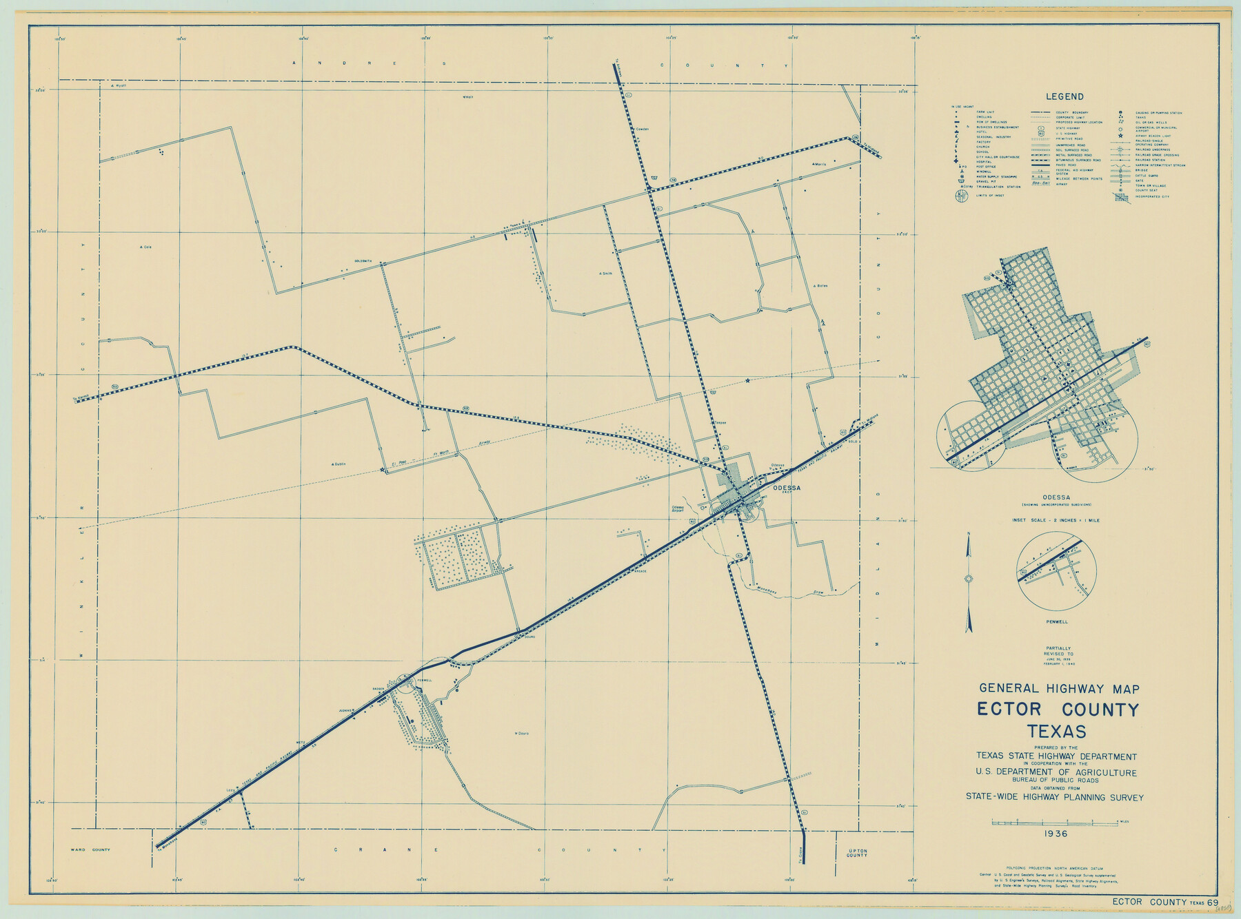
General Highway Map, Ector County, Texas
-
Map/Doc
79081
-
Collection
Texas State Library and Archives
-
Object Dates
1940 (Creation Date)
-
People and Organizations
Texas State Highway Department (Publisher)
-
Counties
Ector
-
Subjects
County
-
Height x Width
18.4 x 24.9 inches
46.7 x 63.3 cm
-
Comments
Prints available courtesy of the Texas State Library and Archives.
More info can be found here: TSLAC Map 04850
Part of: Texas State Library and Archives
General Highway Map, Cooke County, Texas

Print $20.00
General Highway Map, Cooke County, Texas
1961
Size 24.8 x 18.2 inches
Map/Doc 79421
General Highway Map, Lubbock County, Texas

Print $20.00
General Highway Map, Lubbock County, Texas
1940
Size 18.3 x 24.7 inches
Map/Doc 79180
General Highway Map. Detail of Cities and Towns in Bexar County, Texas. City Map of San Antonio, Alamo Heights, Olmos Park, Terrell Hills, Castle Hills, Balcones Heights, and vicinity, Bexar County, Texas

Print $20.00
General Highway Map. Detail of Cities and Towns in Bexar County, Texas. City Map of San Antonio, Alamo Heights, Olmos Park, Terrell Hills, Castle Hills, Balcones Heights, and vicinity, Bexar County, Texas
1961
Size 25.0 x 18.1 inches
Map/Doc 79374
General Highway Map, El Paso County, Texas

Print $20.00
General Highway Map, El Paso County, Texas
1961
Size 18.2 x 24.6 inches
Map/Doc 79459
General Highway Map. Detail of Cities and Towns in Harris County, Texas

Print $20.00
General Highway Map. Detail of Cities and Towns in Harris County, Texas
1939
Size 18.4 x 24.9 inches
Map/Doc 79117
General Highway Map, Freestone County, Texas

Print $20.00
General Highway Map, Freestone County, Texas
1940
Size 18.6 x 25.1 inches
Map/Doc 79094
Railroad and County Map of Texas

Print $20.00
Railroad and County Map of Texas
1903
Size 33.5 x 37.4 inches
Map/Doc 76224
General Highway Map. Detail of Cities and Towns in Lubbock County, Texas [Lubbock and vicinity]
![79579, General Highway Map. Detail of Cities and Towns in Lubbock County, Texas [Lubbock and vicinity], Texas State Library and Archives](https://historictexasmaps.com/wmedia_w700/maps/79579.tif.jpg)
Print $20.00
General Highway Map. Detail of Cities and Towns in Lubbock County, Texas [Lubbock and vicinity]
1961
Size 18.2 x 24.7 inches
Map/Doc 79579
Map of Texas, compiled from surveys on record in the General Land Office of the Republic

Print $20.00
Map of Texas, compiled from surveys on record in the General Land Office of the Republic
1847
Size 32.2 x 25.0 inches
Map/Doc 79325
Map of New Braunfels, Comal County, Texas

Print $20.00
Map of New Braunfels, Comal County, Texas
1868
Size 19.0 x 25.1 inches
Map/Doc 76282
General Highway Map, Potter County, Texas

Print $20.00
General Highway Map, Potter County, Texas
1961
Size 24.5 x 18.2 inches
Map/Doc 79631
General Highway Map, Hudspeth County, Texas

Print $20.00
General Highway Map, Hudspeth County, Texas
1961
Size 25.1 x 18.2 inches
Map/Doc 79527
You may also like
G&H Blocks Gaines Co. Resurvey 1915

Print $40.00
- Digital $50.00
G&H Blocks Gaines Co. Resurvey 1915
1915
Size 56.8 x 31.3 inches
Map/Doc 89632
Willacy County

Print $20.00
- Digital $50.00
Willacy County
1921
Size 25.3 x 32.5 inches
Map/Doc 95675
Flight Mission No. BQR-4K, Frame 60, Brazoria County

Print $20.00
- Digital $50.00
Flight Mission No. BQR-4K, Frame 60, Brazoria County
1952
Size 18.7 x 22.4 inches
Map/Doc 83993
Taylor County

Print $20.00
- Digital $50.00
Taylor County
1934
Size 42.0 x 36.6 inches
Map/Doc 77432
Cameron County Rolled Sketch 14

Print $53.00
- Digital $50.00
Cameron County Rolled Sketch 14
1954
Size 6.8 x 8.8 inches
Map/Doc 43894
Map of Harrison County

Print $20.00
- Digital $50.00
Map of Harrison County
1840
Size 44.6 x 34.5 inches
Map/Doc 1515

Edwards County Working Sketch 131

Print $20.00
- Digital $50.00
Edwards County Working Sketch 131
1984
Size 21.0 x 18.6 inches
Map/Doc 69007
Jefferson County Rolled Sketch 44

Print $20.00
- Digital $50.00
Jefferson County Rolled Sketch 44
1957
Size 26.9 x 25.5 inches
Map/Doc 6401
Randall County Rolled Sketch 2

Print $20.00
- Digital $50.00
Randall County Rolled Sketch 2
1941
Size 31.9 x 23.9 inches
Map/Doc 7422
Liberty County Sketch File 66

Print $10.00
- Digital $50.00
Liberty County Sketch File 66
1900
Size 10.8 x 7.1 inches
Map/Doc 30130
W. T. Noelke Ranch in Crockett County

Print $20.00
- Digital $50.00
W. T. Noelke Ranch in Crockett County
1928
Size 17.4 x 22.2 inches
Map/Doc 90321