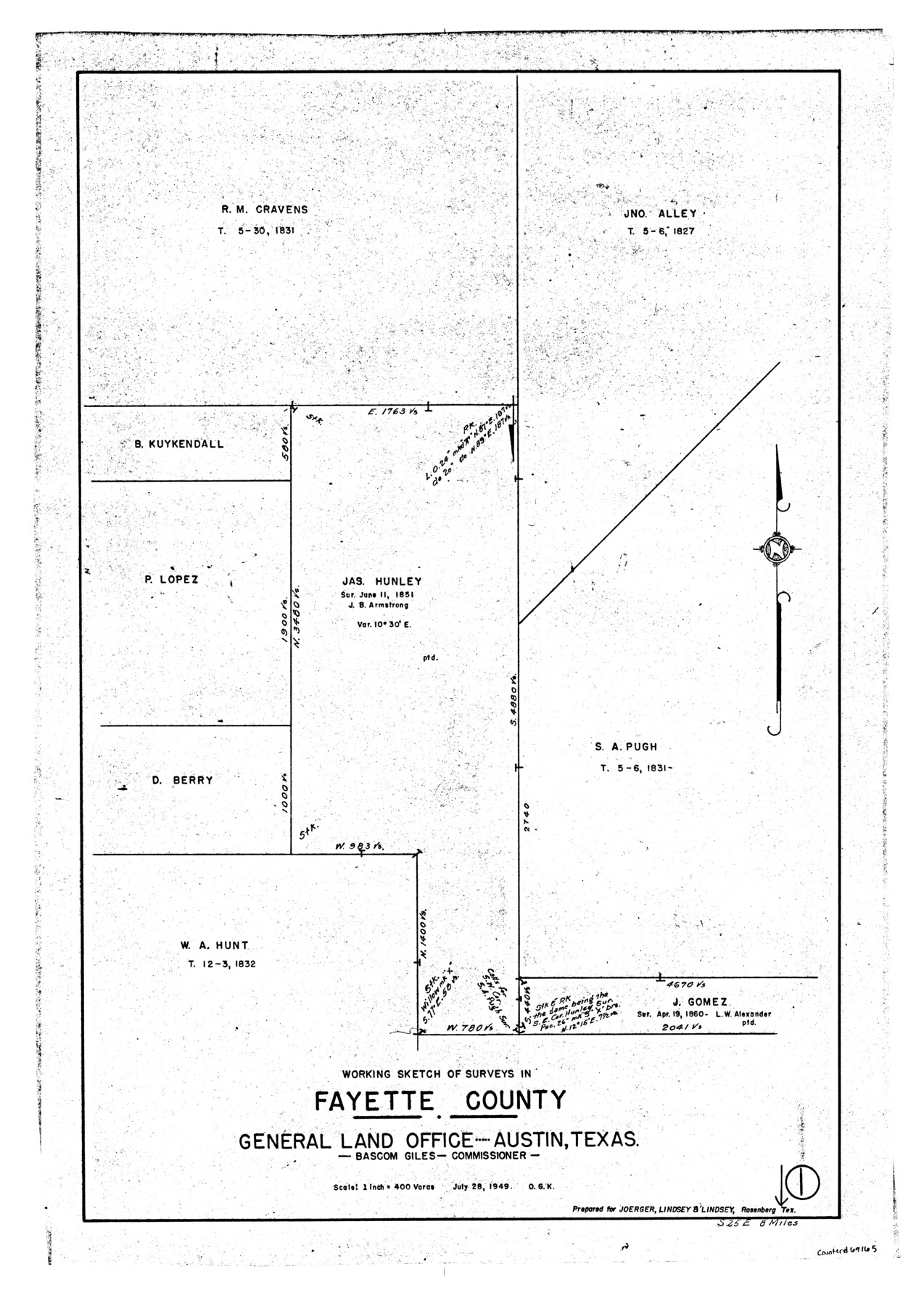
Fayette County Working Sketch 1
-
Map/Doc
69165
-
Collection
General Map Collection
-
Object Dates
7/28/1949 (Creation Date)
-
People and Organizations
Otto G. Kurio (Draftsman)
-
Counties
Fayette
-
Subjects
Surveying Working Sketch
-
Height x Width
25.4 x 18.0 inches
64.5 x 45.7 cm
-
Scale
1" = 400 varas
Part of: General Map Collection
Flight Mission No. DIX-5P, Frame 140, Aransas County

Print $20.00
- Digital $50.00
Flight Mission No. DIX-5P, Frame 140, Aransas County
1956
Size 17.8 x 18.5 inches
Map/Doc 83801
Blanco County Working Sketch 11

Print $3.00
- Digital $50.00
Blanco County Working Sketch 11
1941
Size 10.8 x 10.4 inches
Map/Doc 67371
Current Miscellaneous File 9

Print $66.00
- Digital $50.00
Current Miscellaneous File 9
Size 6.5 x 8.2 inches
Map/Doc 73741
Kimble County Working Sketch 78

Print $20.00
- Digital $50.00
Kimble County Working Sketch 78
1970
Size 46.0 x 31.6 inches
Map/Doc 70146

Grimes County Working Sketch 3

Print $20.00
- Digital $50.00
Grimes County Working Sketch 3
1946
Size 34.1 x 29.1 inches
Map/Doc 63294
Flight Mission No. CLL-1N, Frame 11, Willacy County

Print $20.00
- Digital $50.00
Flight Mission No. CLL-1N, Frame 11, Willacy County
1954
Size 18.5 x 22.2 inches
Map/Doc 86998
Sulphur River, Turner Lake Sheet, Cuthand Creek

Print $20.00
- Digital $50.00
Sulphur River, Turner Lake Sheet, Cuthand Creek
1922
Size 28.5 x 34.3 inches
Map/Doc 65157
Val Verde County Sketch File A3

Print $20.00
- Digital $50.00
Val Verde County Sketch File A3
1917
Size 25.6 x 42.3 inches
Map/Doc 10418
Mexico und Texas

Print $20.00
- Digital $50.00
Mexico und Texas
1851
Size 15.8 x 19.1 inches
Map/Doc 93714
Lamb County Sketch File B

Print $6.00
- Digital $50.00
Lamb County Sketch File B
1902
Size 11.2 x 8.8 inches
Map/Doc 29344
Mitchell County Sketch File 6

Print $40.00
- Digital $50.00
Mitchell County Sketch File 6
Size 12.4 x 13.5 inches
Map/Doc 31692
You may also like
Montgomery County Sketch File 24

Print $6.00
- Digital $50.00
Montgomery County Sketch File 24
Size 12.2 x 8.0 inches
Map/Doc 31867

[Three Positions Concluded, Exhibit F]
![91371, [Three Positions Concluded, Exhibit F], Twichell Survey Records](https://historictexasmaps.com/wmedia_w700/maps/91371-1.tif.jpg)
Print $20.00
- Digital $50.00
[Three Positions Concluded, Exhibit F]
Size 26.0 x 16.4 inches
Map/Doc 91371
Marion County Working Sketch 23

Print $20.00
- Digital $50.00
Marion County Working Sketch 23
1960
Size 24.4 x 25.9 inches
Map/Doc 70799
Erath County Working Sketch 34

Print $20.00
- Digital $50.00
Erath County Working Sketch 34
1972
Size 38.7 x 25.3 inches
Map/Doc 69115
Fort Bend County Rolled Sketch 6

Print $20.00
- Digital $50.00
Fort Bend County Rolled Sketch 6
1967
Size 26.1 x 35.4 inches
Map/Doc 5897
United States Population Distribution by County and Territory, per the U.S. Census of 1870

United States Population Distribution by County and Territory, per the U.S. Census of 1870
2025
Size 8.5 x 11.0 inches
Map/Doc 97479
Edwards County Working Sketch 95

Print $20.00
- Digital $50.00
Edwards County Working Sketch 95
1968
Size 26.0 x 24.9 inches
Map/Doc 68971
Zavala County Boundary File 2a

Print $56.00
- Digital $50.00
Zavala County Boundary File 2a
Size 14.2 x 8.8 inches
Map/Doc 60248
Bell County Sketch File 9

Print $4.00
- Digital $50.00
Bell County Sketch File 9
Size 10.0 x 8.2 inches
Map/Doc 14379
Floyd County Boundary File 2a

Print $40.00
- Digital $50.00
Floyd County Boundary File 2a
Size 19.8 x 39.2 inches
Map/Doc 53488
Leon County Working Sketch 43

Print $40.00
- Digital $50.00
Leon County Working Sketch 43
1980
Size 55.1 x 38.0 inches
Map/Doc 70442