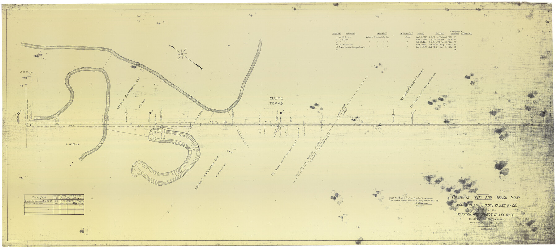
Right-of-Way & Track Map, Houston and Brazos Valley Ry. Co. operated by the Houston and Brazos Valley Ry. Co.
Station 638+07 to Station 848+00
Z-2-185
-
Map/Doc
64605
-
Collection
General Map Collection
-
Object Dates
3/30/1918 (Creation Date)
8/10/1929 (Revision Date)
12/29/1930 (Revision Date)
-
People and Organizations
A. Munson (Surveyor/Engineer)
J. H. Cain (Draftsman)
J. T. Alley (Draftsman)
-
Counties
Brazoria
-
Subjects
Railroads
-
Height x Width
25.0 x 55.7 inches
63.5 x 141.5 cm
-
Medium
blueprint/diazo
-
Scale
1" = 400 feet
-
Comments
See counter nos. 64602 through 64604 and 64606 through 64611 and 66713 for other sheets.
-
Features
H&BV
Highway 285
Clute
[Railroad line] to Anchor
Oyster Creek
Lake Ben
Part of: General Map Collection
Val Verde County Rolled Sketch 74

Print $20.00
- Digital $50.00
Val Verde County Rolled Sketch 74
Size 18.9 x 19.5 inches
Map/Doc 8137
Map of Galveston, Turtle & East Bays & portion of the Gulf of Mexico in Chambers & Galveston Counties, Texas showing subdivision therof for mineral development

Print $20.00
- Digital $50.00
Map of Galveston, Turtle & East Bays & portion of the Gulf of Mexico in Chambers & Galveston Counties, Texas showing subdivision therof for mineral development
1935
Size 40.7 x 47.7 inches
Map/Doc 2939
Dawson County Working Sketch 13

Print $20.00
- Digital $50.00
Dawson County Working Sketch 13
1952
Size 18.1 x 12.6 inches
Map/Doc 68557
Coke County Rolled Sketch 18

Print $20.00
- Digital $50.00
Coke County Rolled Sketch 18
Size 43.4 x 34.4 inches
Map/Doc 8632
Map of Carson County

Print $20.00
- Digital $50.00
Map of Carson County
1898
Size 41.2 x 33.8 inches
Map/Doc 4750
McMullen County Rolled Sketch 22

Print $20.00
- Digital $50.00
McMullen County Rolled Sketch 22
2004
Size 15.3 x 24.6 inches
Map/Doc 88824
Williamson County Working Sketch 9

Print $20.00
- Digital $50.00
Williamson County Working Sketch 9
1954
Size 31.2 x 30.0 inches
Map/Doc 72569
Washington County

Print $20.00
- Digital $50.00
Washington County
1976
Size 31.7 x 46.5 inches
Map/Doc 73317
Sutton County Sketch File 6a

Print $6.00
- Digital $50.00
Sutton County Sketch File 6a
1898
Size 7.5 x 6.4 inches
Map/Doc 37362
Martin County

Print $20.00
- Digital $50.00
Martin County
1933
Size 43.8 x 38.9 inches
Map/Doc 73230
Texas 1849: A Lone Star Rising

Print $20.00
- Digital $50.00
Texas 1849: A Lone Star Rising
2000
Size 40.6 x 40.7 inches
Map/Doc 78270

You may also like
Harris County NRC Article 33.136 Sketch 20

Print $22.00
- Digital $50.00
Harris County NRC Article 33.136 Sketch 20
2022
Map/Doc 96896
Revised map of west half of Sabine Lake and Sabine Pass, showing subdivision for mineral development; Jefferson and Orange Counties

Print $40.00
- Digital $50.00
Revised map of west half of Sabine Lake and Sabine Pass, showing subdivision for mineral development; Jefferson and Orange Counties
1979
Size 72.1 x 41.5 inches
Map/Doc 1935
Terrell County Sketch File 9

Print $12.00
- Digital $50.00
Terrell County Sketch File 9
Size 9.8 x 8.5 inches
Map/Doc 37904
El Paso County Rolled Sketch 63

Print $20.00
- Digital $50.00
El Paso County Rolled Sketch 63
1996
Size 24.7 x 36.8 inches
Map/Doc 5855
Upton County Sketch File 20

Print $40.00
- Digital $50.00
Upton County Sketch File 20
1927
Size 18.5 x 29.2 inches
Map/Doc 12516
List of County School Lands

Print $20.00
- Digital $50.00
List of County School Lands
Size 18.4 x 23.4 inches
Map/Doc 65798
[Blks A, B and C, and Irion, Floyd, Sutton and Lubbock County School Land Leagues]
![90202, [Blks A, B and C, and Irion, Floyd, Sutton and Lubbock County School Land Leagues], Twichell Survey Records](https://historictexasmaps.com/wmedia_w700/maps/90202-1.tif.jpg)
Print $20.00
- Digital $50.00
[Blks A, B and C, and Irion, Floyd, Sutton and Lubbock County School Land Leagues]
Size 15.6 x 19.2 inches
Map/Doc 90202
Intracoastal Waterway in Texas - Corpus Christi to Point Isabel including Arroyo Colorado to Mo. Pac. R.R. Bridge Near Harlingen

Print $20.00
- Digital $50.00
Intracoastal Waterway in Texas - Corpus Christi to Point Isabel including Arroyo Colorado to Mo. Pac. R.R. Bridge Near Harlingen
1934
Size 22.0 x 32.7 inches
Map/Doc 61884
Concho County Sketch File X

Print $20.00
- Digital $50.00
Concho County Sketch File X
1916
Size 39.4 x 23.7 inches
Map/Doc 11168
Perspective Map of the City of Laredo

Print $20.00
- Digital $50.00
Perspective Map of the City of Laredo
1892
Size 24.2 x 36.3 inches
Map/Doc 97096
Map of San Jacinto County

Print $20.00
- Digital $50.00
Map of San Jacinto County
1872
Size 22.0 x 18.6 inches
Map/Doc 1346
Real County Rolled Sketch 10

Print $20.00
- Digital $50.00
Real County Rolled Sketch 10
Size 43.7 x 34.3 inches
Map/Doc 9835