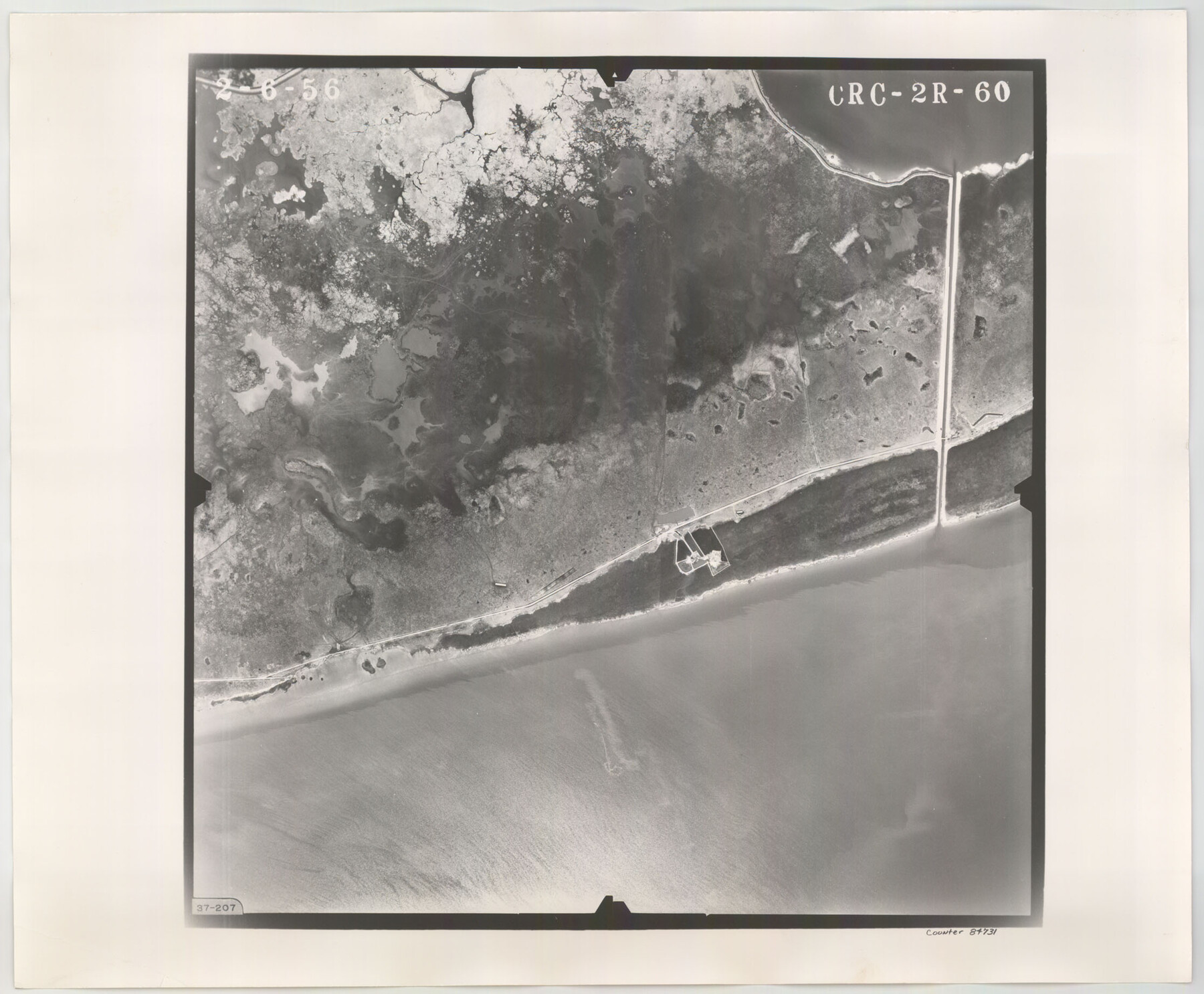
Flight Mission No. CRC-2R, Frame 60, Chambers County
CRC-2R-60
-
Map/Doc
84731
-
Collection
General Map Collection
-
Object Dates
1956/2/6 (Creation Date)
-
People and Organizations
U. S. Department of Agriculture (Publisher)
-
Counties
Chambers
-
Subjects
Aerial Photograph
-
Height x Width
18.4 x 22.3 inches
46.7 x 56.6 cm
-
Comments
Flown by Jack Ammann Photogrammetric Engineers, Inc. of San Antonio, Texas.
Part of: General Map Collection
Schleicher County Sketch File 42

Print $40.00
- Digital $50.00
Schleicher County Sketch File 42
1963
Size 16.3 x 14.4 inches
Map/Doc 36546
Newton County Rolled Sketch 20

Print $40.00
- Digital $50.00
Newton County Rolled Sketch 20
1956
Size 41.4 x 48.0 inches
Map/Doc 9581
Hutchinson County Rolled Sketch 12

Print $20.00
- Digital $50.00
Hutchinson County Rolled Sketch 12
Size 26.1 x 41.4 inches
Map/Doc 6282
Map of Houston, Harris County, Texas

Print $20.00
- Digital $50.00
Map of Houston, Harris County, Texas
1900
Size 38.5 x 32.0 inches
Map/Doc 93390
Matagorda County Sketch File 42

Print $38.00
- Digital $50.00
Matagorda County Sketch File 42
1912
Size 14.2 x 8.8 inches
Map/Doc 30834
Chambers County Working Sketch 28

Print $20.00
- Digital $50.00
Chambers County Working Sketch 28
1982
Size 28.7 x 42.3 inches
Map/Doc 68011
County of Galveston, Texas

Print $20.00
- Digital $50.00
County of Galveston, Texas
1845
Size 22.9 x 32.2 inches
Map/Doc 3574
Flight Mission No. DIX-7P, Frame 84, Aransas County

Print $20.00
- Digital $50.00
Flight Mission No. DIX-7P, Frame 84, Aransas County
1956
Size 18.8 x 22.8 inches
Map/Doc 83878
Jefferson County Rolled Sketch 27

Print $20.00
- Digital $50.00
Jefferson County Rolled Sketch 27
1948
Size 24.2 x 46.6 inches
Map/Doc 9292
Lamb County Boundary File 1d

Print $6.00
- Digital $50.00
Lamb County Boundary File 1d
Size 10.2 x 8.2 inches
Map/Doc 56051
Collingsworth County Rolled Sketch 2

Print $20.00
- Digital $50.00
Collingsworth County Rolled Sketch 2
1888
Size 30.2 x 24.8 inches
Map/Doc 5531
Dawson County Working Sketch Graphic Index

Print $20.00
- Digital $50.00
Dawson County Working Sketch Graphic Index
1959
Size 40.7 x 33.4 inches
Map/Doc 76518
You may also like
[City of Lamesa and vicinity]
![92593, [City of Lamesa and vicinity], Twichell Survey Records](https://historictexasmaps.com/wmedia_w700/maps/92593-1.tif.jpg)
Print $20.00
- Digital $50.00
[City of Lamesa and vicinity]
1946
Size 33.9 x 10.5 inches
Map/Doc 92593
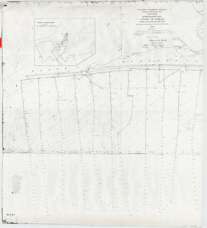
Hydography Survey H-1465 Corpus Christi Pass
Print $20.00
- Digital $50.00
Hydography Survey H-1465 Corpus Christi Pass
1880
Size 45.0 x 40.9 inches
Map/Doc 2695
Edwards County Working Sketch 31

Print $20.00
- Digital $50.00
Edwards County Working Sketch 31
1947
Size 33.5 x 47.5 inches
Map/Doc 68907
Chambers County Working Sketch 13

Print $20.00
- Digital $50.00
Chambers County Working Sketch 13
1956
Size 30.1 x 24.6 inches
Map/Doc 67996
Archer County Sketch File 28-1

Print $40.00
- Digital $50.00
Archer County Sketch File 28-1
1928
Size 23.8 x 22.0 inches
Map/Doc 10834
Aransas Pass to Baffin Bay

Print $20.00
- Digital $50.00
Aransas Pass to Baffin Bay
1937
Size 41.6 x 34.5 inches
Map/Doc 73410
Mills County Working Sketch 16

Print $20.00
- Digital $50.00
Mills County Working Sketch 16
1963
Size 20.2 x 18.3 inches
Map/Doc 71046
[Surveys on Trespalacios Bay]
![19, [Surveys on Trespalacios Bay], General Map Collection](https://historictexasmaps.com/wmedia_w700/maps/19.tif.jpg)
Print $2.00
- Digital $50.00
[Surveys on Trespalacios Bay]
Size 7.2 x 9.6 inches
Map/Doc 19
Padre Island National Seashore, Texas - Dependent Resurvey

Print $4.00
- Digital $50.00
Padre Island National Seashore, Texas - Dependent Resurvey
2001
Size 18.2 x 24.3 inches
Map/Doc 60552
Harris County Historic Topographic 26

Print $20.00
- Digital $50.00
Harris County Historic Topographic 26
1916
Size 29.2 x 22.8 inches
Map/Doc 65837
The Republic County of Fayette. December 29, 1845

Print $20.00
The Republic County of Fayette. December 29, 1845
2020
Size 14.7 x 21.7 inches
Map/Doc 96136
Coast Chart No. 210 Aransas Pass and Corpus Christi Bay with the coast to latitude 27° 12' Texas

Print $20.00
- Digital $50.00
Coast Chart No. 210 Aransas Pass and Corpus Christi Bay with the coast to latitude 27° 12' Texas
1913
Size 27.0 x 18.2 inches
Map/Doc 72800