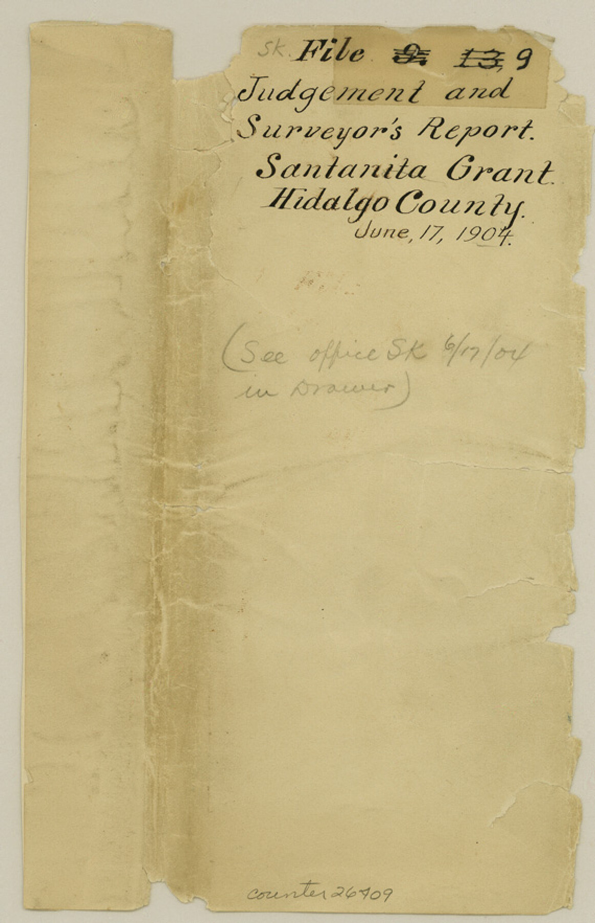
Hidalgo County Sketch File 9
[Judgement and surveyor's report regarding Santanita grant]
-
Map/Doc
26409
-
Collection
General Map Collection
-
Object Dates
6/17/1904 (Creation Date)
2/1908 (Survey Date)
7/1798 (Survey Date)
3/1808 (Survey Date)
12/17/1882 (Survey Date)
10/1853 (Survey Date)
5/1875 (Survey Date)
8/7/1877 (Survey Date)
3/4/1893 (Creation Date)
3/10/1893 (File Date)
-
People and Organizations
S.W. DeWolf (Surveyor/Engineer)
J.J. Cocke (Surveyor/Engineer)
Jno. J. Hord (Surveyor/Engineer)
-
Counties
Hidalgo Cameron Starr
-
Subjects
Surveying Sketch File
-
Height x Width
8.8 x 5.7 inches
22.4 x 14.5 cm
-
Medium
multi-page, multi-format
-
Features
Hidalgo
Agua Negra
Salt Lake
Part of: General Map Collection
[Surveys along the Salado and Lampasas Rivers and Saltillo Creek]
![82159, [Surveys along the Salado and Lampasas Rivers and Saltillo Creek], General Map Collection](https://historictexasmaps.com/wmedia_w700/maps/82159.tif.jpg)
Print $2.00
- Digital $50.00
[Surveys along the Salado and Lampasas Rivers and Saltillo Creek]
1845
Size 13.1 x 7.7 inches
Map/Doc 82159
No. 1 - Survey for a road from the Brazo Santiago to the Rio Grande

Print $20.00
- Digital $50.00
No. 1 - Survey for a road from the Brazo Santiago to the Rio Grande
1847
Size 18.3 x 27.2 inches
Map/Doc 72874
Van Zandt County Sketch File 16a

Print $4.00
- Digital $50.00
Van Zandt County Sketch File 16a
1858
Size 8.5 x 8.0 inches
Map/Doc 39412
Northeast Part of Crockett County

Print $20.00
- Digital $50.00
Northeast Part of Crockett County
1976
Size 31.4 x 41.0 inches
Map/Doc 77253
Val Verde County Working Sketch 103

Print $20.00
- Digital $50.00
Val Verde County Working Sketch 103
1981
Size 37.1 x 39.9 inches
Map/Doc 72238
Denton County Working Sketch 34

Print $20.00
- Digital $50.00
Denton County Working Sketch 34
2005
Size 22.2 x 27.3 inches
Map/Doc 83570
Val Verde County Sketch File A4

Print $10.00
- Digital $50.00
Val Verde County Sketch File A4
1897
Size 9.2 x 8.5 inches
Map/Doc 39046

Reagan County Rolled Sketch 20

Print $20.00
- Digital $50.00
Reagan County Rolled Sketch 20
1948
Size 45.8 x 45.0 inches
Map/Doc 9814
Map of Freestone County

Print $20.00
- Digital $50.00
Map of Freestone County
1874
Size 21.8 x 24.5 inches
Map/Doc 3563
Hardin County Working Sketch 3

Print $3.00
- Digital $50.00
Hardin County Working Sketch 3
1906
Size 9.1 x 11.0 inches
Map/Doc 63401
Map of Parker County

Print $20.00
- Digital $50.00
Map of Parker County
1860
Size 24.1 x 19.0 inches
Map/Doc 3945
You may also like
Travis County Sketch File 66

Print $12.00
- Digital $50.00
Travis County Sketch File 66
1950
Size 14.2 x 9.0 inches
Map/Doc 38440
Webb County Working Sketch 14

Print $20.00
- Digital $50.00
Webb County Working Sketch 14
1923
Size 19.3 x 32.2 inches
Map/Doc 72379
Glasscock County Sketch File 1

Print $46.00
- Digital $50.00
Glasscock County Sketch File 1
Size 26.1 x 31.8 inches
Map/Doc 11558
Red River County Working Sketch 19

Print $40.00
- Digital $50.00
Red River County Working Sketch 19
1955
Size 55.0 x 38.6 inches
Map/Doc 72002
Seagraves Chamber of Commerce Subdivision of Northeast Quarter of Southeast Quarter of Section 9, Block C-34, Gaines County, Texas

Print $20.00
- Digital $50.00
Seagraves Chamber of Commerce Subdivision of Northeast Quarter of Southeast Quarter of Section 9, Block C-34, Gaines County, Texas
1955
Size 16.7 x 18.2 inches
Map/Doc 92684
Wharton County Working Sketch 5

Print $20.00
- Digital $50.00
Wharton County Working Sketch 5
Size 20.2 x 15.6 inches
Map/Doc 72469
Flight Mission No. CUG-2P, Frame 66, Kleberg County

Print $20.00
- Digital $50.00
Flight Mission No. CUG-2P, Frame 66, Kleberg County
1956
Size 18.5 x 22.2 inches
Map/Doc 86203
Lubbock County Working Sketch Graphic Index

Print $20.00
- Digital $50.00
Lubbock County Working Sketch Graphic Index
1968
Size 41.3 x 33.7 inches
Map/Doc 76626
[Plat and field notes of 3.107 acre tract for Clement Cove Harbor Company]
![60397, [Plat and field notes of 3.107 acre tract for Clement Cove Harbor Company], General Map Collection](https://historictexasmaps.com/wmedia_w700/maps/60397-1.tif.jpg)
Print $20.00
- Digital $50.00
[Plat and field notes of 3.107 acre tract for Clement Cove Harbor Company]
1987
Size 24.2 x 36.5 inches
Map/Doc 60397
[Town Plat of Galveston]
![76258, [Town Plat of Galveston], Texas State Library and Archives](https://historictexasmaps.com/wmedia_w700/maps/76258.tif.jpg)
Print $20.00
[Town Plat of Galveston]
1877
Size 9.1 x 14.5 inches
Map/Doc 76258
San Patricio County Aerial Photograph Index Sheet 4

Print $20.00
- Digital $50.00
San Patricio County Aerial Photograph Index Sheet 4
1957
Size 23.3 x 19.3 inches
Map/Doc 83746
Yellow House Land Company's Subdivision of State Capitol Leagues Hockley and Lamb Counties, Texas

Print $20.00
- Digital $50.00
Yellow House Land Company's Subdivision of State Capitol Leagues Hockley and Lamb Counties, Texas
Size 22.4 x 23.0 inches
Map/Doc 92206