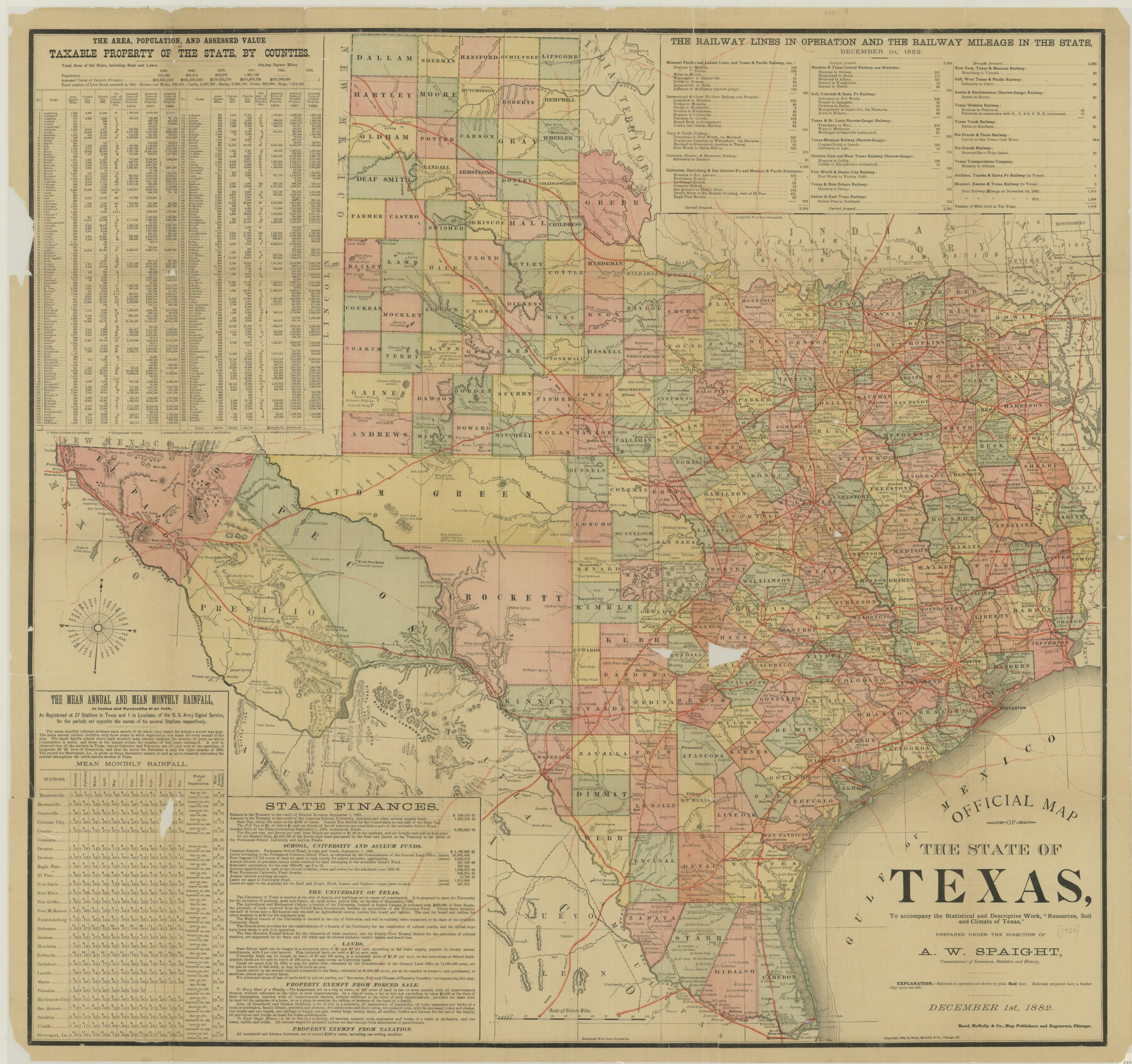
Official Map of the State of Texas to accompany the Statistical and Descriptive Work, "Resources, Soil and Climate of Texas"
-
Map/Doc
76257
-
Collection
Texas State Library and Archives
-
Object Dates
12/1/1882 (Creation Date)
-
People and Organizations
Rand, McNally and Company (Publisher)
-
Subjects
State of Texas
-
Height x Width
32.3 x 34.4 inches
82.0 x 87.4 cm
-
Comments
Prints available courtesy of the Texas State Library and Archives.
More info can be found here: TSLAC Map 01924
Part of: Texas State Library and Archives
General Highway Map, Frio County, Texas

Print $20.00
General Highway Map, Frio County, Texas
1940
Size 18.4 x 24.9 inches
Map/Doc 79095
General Highway Map, Gray County, Texas

Print $20.00
General Highway Map, Gray County, Texas
1940
Size 25.0 x 18.4 inches
Map/Doc 79103
General Highway Map, Dimmit County, La Salle County, Texas

Print $20.00
General Highway Map, Dimmit County, La Salle County, Texas
1940
Size 18.4 x 25.2 inches
Map/Doc 79077
General Highway Map, Coke County, Texas

Print $20.00
General Highway Map, Coke County, Texas
1940
Size 18.4 x 25.2 inches
Map/Doc 79049
General Highway Map, Hill County, Texas

Print $20.00
General Highway Map, Hill County, Texas
1940
Size 25.0 x 18.6 inches
Map/Doc 79129
General Highway Map, Randall County, Texas

Print $20.00
General Highway Map, Randall County, Texas
1961
Size 18.1 x 24.5 inches
Map/Doc 79635
General Highway Map. Detail of Cities and Towns in Potter County, Texas [Amarillo and vicinity]
![79221, General Highway Map. Detail of Cities and Towns in Potter County, Texas [Amarillo and vicinity], Texas State Library and Archives](https://historictexasmaps.com/wmedia_w700/maps/79221.tif.jpg)
Print $20.00
General Highway Map. Detail of Cities and Towns in Potter County, Texas [Amarillo and vicinity]
1940
Size 24.6 x 18.2 inches
Map/Doc 79221
Classification of Land Uses in Texas by Counties

Print $20.00
Classification of Land Uses in Texas by Counties
1935
Size 35.6 x 46.1 inches
Map/Doc 76310
[General Highway Map Supplementary Sheet Showing Detail of Cities and Towns in Bexar County Texas]
![76289, [General Highway Map Supplementary Sheet Showing Detail of Cities and Towns in Bexar County Texas], Texas State Library and Archives](https://historictexasmaps.com/wmedia_w700/maps/76289.tif.jpg)
Print $20.00
[General Highway Map Supplementary Sheet Showing Detail of Cities and Towns in Bexar County Texas]
1936
Size 18.7 x 24.9 inches
Map/Doc 76289
General Highway Map, Jack County, Texas

Print $20.00
General Highway Map, Jack County, Texas
1940
Size 18.4 x 24.8 inches
Map/Doc 79139
General Highway Map. Detail of Cities and Towns in Lubbock County, Texas [Lubbock and vicinity]
![79579, General Highway Map. Detail of Cities and Towns in Lubbock County, Texas [Lubbock and vicinity], Texas State Library and Archives](https://historictexasmaps.com/wmedia_w700/maps/79579.tif.jpg)
Print $20.00
General Highway Map. Detail of Cities and Towns in Lubbock County, Texas [Lubbock and vicinity]
1961
Size 18.2 x 24.7 inches
Map/Doc 79579
General Highway Map, Jackson County, Texas

Print $20.00
General Highway Map, Jackson County, Texas
1940
Size 18.3 x 24.8 inches
Map/Doc 79140
You may also like
Howard County Working Sketch 2

Print $20.00
- Digital $50.00
Howard County Working Sketch 2
1903
Size 21.7 x 20.9 inches
Map/Doc 66268
[Sketch in Hutchinson County, Texas]
![76016, [Sketch in Hutchinson County, Texas], Maddox Collection](https://historictexasmaps.com/wmedia_w700/maps/76016.tif.jpg)
Print $20.00
- Digital $50.00
[Sketch in Hutchinson County, Texas]
Size 26.5 x 35.3 inches
Map/Doc 76016
Map of Falls County

Print $20.00
- Digital $50.00
Map of Falls County
1855
Size 21.4 x 23.9 inches
Map/Doc 3532
Reconnoissance of Sabine River and Valley

Print $20.00
Reconnoissance of Sabine River and Valley
1863
Size 42.5 x 30.3 inches
Map/Doc 97500
Erath County Sketch File 3

Print $4.00
- Digital $50.00
Erath County Sketch File 3
1853
Size 13.0 x 8.3 inches
Map/Doc 22255
Flight Mission No. BQR-20K, Frame 12, Brazoria County

Print $20.00
- Digital $50.00
Flight Mission No. BQR-20K, Frame 12, Brazoria County
1952
Size 18.6 x 22.4 inches
Map/Doc 84114
General Highway Map, Chambers County, Texas

Print $20.00
General Highway Map, Chambers County, Texas
1940
Size 18.4 x 25.3 inches
Map/Doc 79044
Brewster County Working Sketch 32

Print $20.00
- Digital $50.00
Brewster County Working Sketch 32
1943
Size 28.3 x 28.3 inches
Map/Doc 67566
Throckmorton County Boundary File 2

Print $34.00
- Digital $50.00
Throckmorton County Boundary File 2
Size 8.3 x 5.7 inches
Map/Doc 59264
Llano County Working Sketch 2

Print $20.00
- Digital $50.00
Llano County Working Sketch 2
1949
Size 21.0 x 24.3 inches
Map/Doc 70620
General Highway Map, El Paso County, Texas

Print $20.00
General Highway Map, El Paso County, Texas
1961
Size 18.4 x 24.6 inches
Map/Doc 79455
Pas Kaart van de Golff van Mexico

Print $20.00
- Digital $50.00
Pas Kaart van de Golff van Mexico
1695
Size 21.4 x 25.4 inches
Map/Doc 94081