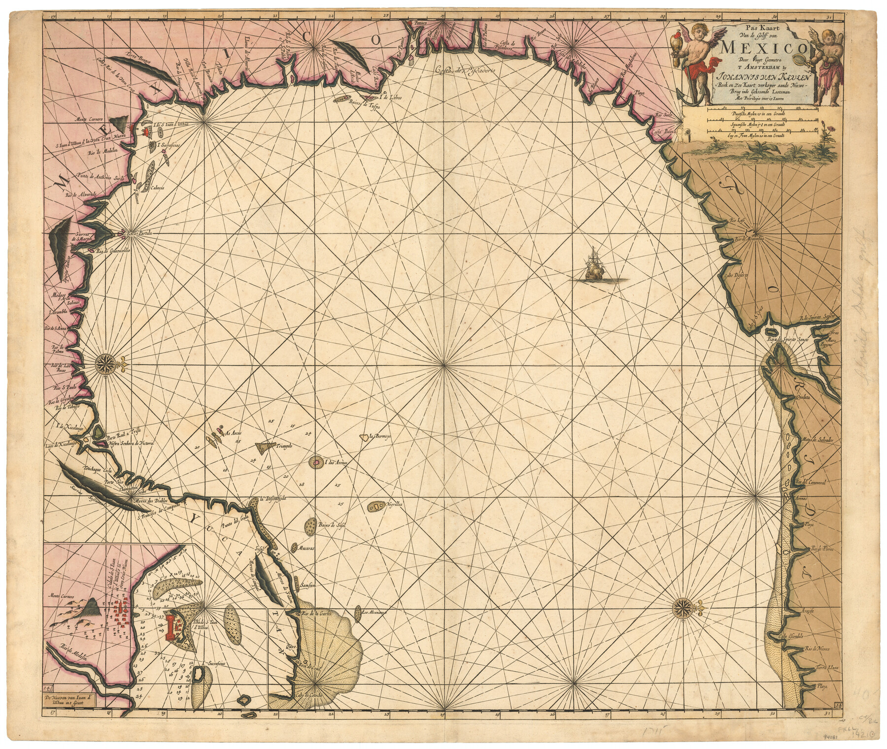
Pas Kaart van de Golff van Mexico
-
Map/Doc
94081
-
Collection
General Map Collection
-
Object Dates
1695 (Creation Date)
-
People and Organizations
Claes Janszoon Vooght (Cartographer)
Johannes van Keulen (Author)
-
Subjects
Gulf of Mexico Nautical Charts
-
Height x Width
21.4 x 25.4 inches
54.4 x 64.5 cm
-
Medium
paper, etching/engraving/lithograph
-
Comments
Relief shown pictorially. Depths shown by soundings
Shows entire coastline from the Yucatán peninsula in the southwest to western Florida [modern-day Louisiana and Mississippi] with islands, inlets, ports, names of rivers, and notable physical features for the Gulf of Mexico; layout of port and fortress of San Juan d'Ulua at Veracruz
In lower left corner of inset: 14
North oriented toward right
Cartouche features two winged cherubs, one with falcon and anchor, the other with snake and mirror. Includes two compass roses, ship illustration, and rhumb lines
Inset: "De Haaven van Iuan d'Ulhua in t Groot."
Language note: Titles are in Dutch, place names are in Spanish -
URLs
https://medium.com/save-texas-history/mapping-texas-from-frontier-to-the-lone-star-state-sea-chart-of-the-gulf-of-mexico-1695-2875978cdd62#.rillmxs55
Part of: General Map Collection
Hall County Sketch File 36

Print $4.00
- Digital $50.00
Hall County Sketch File 36
1914
Size 11.2 x 8.8 inches
Map/Doc 24895
Flight Mission No. CRE-1R, Frame 66, Jackson County

Print $20.00
- Digital $50.00
Flight Mission No. CRE-1R, Frame 66, Jackson County
1956
Size 16.2 x 16.1 inches
Map/Doc 85329
Cass County Working Sketch 47b

Print $20.00
- Digital $50.00
Cass County Working Sketch 47b
1992
Size 32.3 x 36.4 inches
Map/Doc 76063
Castro County Boundary File 1c

Print $40.00
- Digital $50.00
Castro County Boundary File 1c
Size 24.2 x 19.2 inches
Map/Doc 51224
Van Zandt County Sketch File 36

Print $4.00
- Digital $50.00
Van Zandt County Sketch File 36
1864
Size 8.0 x 10.4 inches
Map/Doc 39478
Hutchinson County Rolled Sketch 36A

Print $20.00
- Digital $50.00
Hutchinson County Rolled Sketch 36A
1888
Size 21.3 x 25.0 inches
Map/Doc 6294
Wheeler County Working Sketch 10

Print $40.00
- Digital $50.00
Wheeler County Working Sketch 10
1973
Size 72.4 x 36.6 inches
Map/Doc 72499
Outer Continental Shelf Leasing Maps (Louisiana Offshore Operations)

Print $20.00
- Digital $50.00
Outer Continental Shelf Leasing Maps (Louisiana Offshore Operations)
1955
Size 8.8 x 10.0 inches
Map/Doc 76091
Presidio County Rolled Sketch 102

Print $20.00
- Digital $50.00
Presidio County Rolled Sketch 102
1957
Size 19.3 x 13.8 inches
Map/Doc 7385
Young County Rolled Sketch 19

Print $20.00
- Digital $50.00
Young County Rolled Sketch 19
2021
Size 24.3 x 30.4 inches
Map/Doc 97023
Motley County Sketch File 20 (N)

Print $6.00
- Digital $50.00
Motley County Sketch File 20 (N)
1943
Size 11.3 x 8.8 inches
Map/Doc 32066
Potter County Sketch File 1

Print $28.00
- Digital $50.00
Potter County Sketch File 1
1882
Size 7.4 x 8.8 inches
Map/Doc 34378
You may also like
Terrell County Working Sketch 23

Print $20.00
- Digital $50.00
Terrell County Working Sketch 23
1940
Size 24.1 x 19.1 inches
Map/Doc 62173
Haskell County Sketch File 5

Print $4.00
- Digital $50.00
Haskell County Sketch File 5
1856
Size 10.1 x 8.1 inches
Map/Doc 26124
Bexar County Sketch File 25

Print $4.00
- Digital $50.00
Bexar County Sketch File 25
1860
Size 8.9 x 8.7 inches
Map/Doc 14486
Flight Mission No. DQO-7K, Frame 110, Galveston County

Print $20.00
- Digital $50.00
Flight Mission No. DQO-7K, Frame 110, Galveston County
1952
Size 18.7 x 22.3 inches
Map/Doc 85125

[Texas State Capitol Land Leagues and Surrounding Blocks]
![91055, [Texas State Capitol Land Leagues and Surrounding Blocks], Twichell Survey Records](https://historictexasmaps.com/wmedia_w700/maps/91055-1.tif.jpg)
Print $20.00
- Digital $50.00
[Texas State Capitol Land Leagues and Surrounding Blocks]
Size 30.2 x 33.6 inches
Map/Doc 91055
El Paso County Boundary File 24

Print $32.00
- Digital $50.00
El Paso County Boundary File 24
Size 14.8 x 9.6 inches
Map/Doc 53221
Outer Continental Shelf Leasing Maps (Texas Offshore Operations)

Print $20.00
- Digital $50.00
Outer Continental Shelf Leasing Maps (Texas Offshore Operations)
1954
Size 14.6 x 15.6 inches
Map/Doc 75836
General Highway Map, Grimes County, Texas

Print $20.00
General Highway Map, Grimes County, Texas
1940
Size 25.0 x 18.4 inches
Map/Doc 79106
Uvalde County Working Sketch 61

Print $20.00
- Digital $50.00
Uvalde County Working Sketch 61
1978
Size 40.4 x 37.4 inches
Map/Doc 72131
[Sketch of Surveys in Brooks County, Texas]
![10775, [Sketch of Surveys in Brooks County, Texas], Maddox Collection](https://historictexasmaps.com/wmedia_w700/maps/10775.tif.jpg)
Print $20.00
- Digital $50.00
[Sketch of Surveys in Brooks County, Texas]
Size 12.1 x 12.4 inches
Map/Doc 10775
[Surveys in the Bexar District along the Nueces and Leona Rivers]
![116, [Surveys in the Bexar District along the Nueces and Leona Rivers], General Map Collection](https://historictexasmaps.com/wmedia_w700/maps/116.tif.jpg)
Print $3.00
- Digital $50.00
[Surveys in the Bexar District along the Nueces and Leona Rivers]
1845
Size 10.9 x 14.3 inches
Map/Doc 116