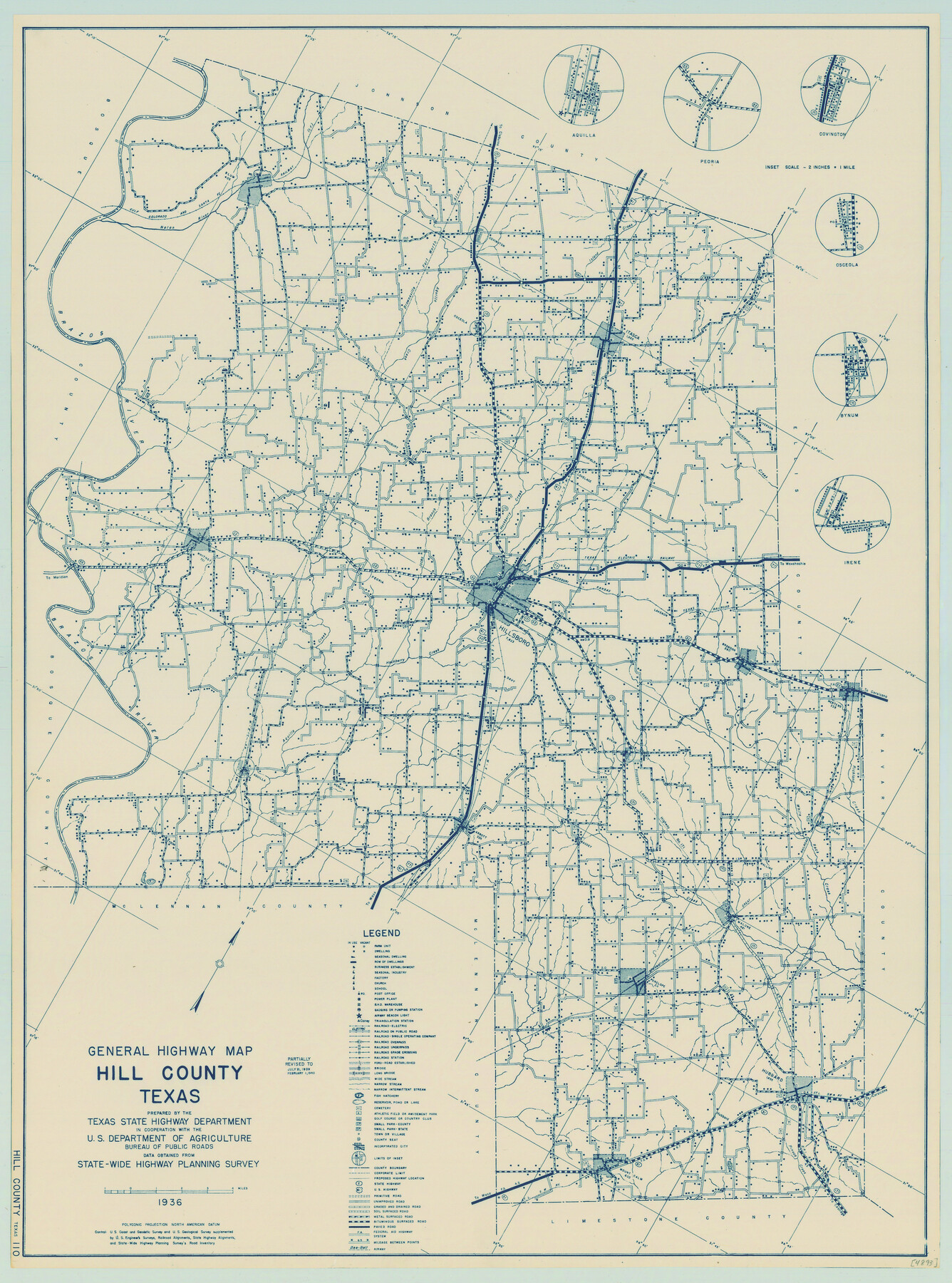
General Highway Map, Hill County, Texas
-
Map/Doc
79129
-
Collection
Texas State Library and Archives
-
Object Dates
1940 (Creation Date)
-
People and Organizations
Texas State Highway Department (Publisher)
-
Counties
Hill
-
Subjects
County
-
Height x Width
25.0 x 18.6 inches
63.5 x 47.2 cm
-
Comments
Prints available courtesy of the Texas State Library and Archives.
More info can be found here: TSLAC Map 04893
Part of: Texas State Library and Archives
General Highway Map, Brazoria County, Texas

Print $20.00
General Highway Map, Brazoria County, Texas
1961
Size 25.0 x 18.2 inches
Map/Doc 79382
General Highway Map, Brewster County, Texas

Print $20.00
General Highway Map, Brewster County, Texas
1940
Size 18.5 x 25.1 inches
Map/Doc 79028
General Highway Map, Sabine County, Texas

Print $20.00
General Highway Map, Sabine County, Texas
1940
Size 24.9 x 18.4 inches
Map/Doc 79234
General Highway Map, Midland County, Texas

Print $20.00
General Highway Map, Midland County, Texas
1961
Size 18.2 x 24.6 inches
Map/Doc 79596
General Highway Map, Yoakum County, Texas

Print $20.00
General Highway Map, Yoakum County, Texas
1940
Size 18.3 x 24.9 inches
Map/Doc 79285
Section across Valley Bench and Terraces - South Side of Red River - Big Bend Area

Print $20.00
Section across Valley Bench and Terraces - South Side of Red River - Big Bend Area
1921
Size 10.2 x 34.8 inches
Map/Doc 79750
Map of Texas, compiled from surveys on record in the General Land Office of the Republic

Print $20.00
Map of Texas, compiled from surveys on record in the General Land Office of the Republic
1847
Size 32.2 x 25.0 inches
Map/Doc 79325
General Highway Map. Detail of Cities and Towns in Dallas County, Texas [Dallas and vicinity]
![79069, General Highway Map. Detail of Cities and Towns in Dallas County, Texas [Dallas and vicinity], Texas State Library and Archives](https://historictexasmaps.com/wmedia_w700/maps/79069.tif.jpg)
Print $20.00
General Highway Map. Detail of Cities and Towns in Dallas County, Texas [Dallas and vicinity]
1936
Size 18.4 x 25.2 inches
Map/Doc 79069
General Highway Map. Detail of Cities of Towns in Bosque County, Texas

Print $20.00
General Highway Map. Detail of Cities of Towns in Bosque County, Texas
1961
Size 18.2 x 24.9 inches
Map/Doc 79379
General Highway Map, Matagorda County, Texas

Print $20.00
General Highway Map, Matagorda County, Texas
1939
Size 24.7 x 18.3 inches
Map/Doc 79187
General Highway Map, Austin County, Texas

Print $20.00
General Highway Map, Austin County, Texas
1939
Size 18.4 x 25.0 inches
Map/Doc 79009
[General Highway Map of] Bexar County, Sheet 1 of 2
![76288, [General Highway Map of] Bexar County, Sheet 1 of 2, Texas State Library and Archives](https://historictexasmaps.com/wmedia_w700/maps/76288.tif.jpg)
Print $20.00
[General Highway Map of] Bexar County, Sheet 1 of 2
1940
Size 18.5 x 25.1 inches
Map/Doc 76288
You may also like
Outer Continental Shelf Leasing Maps (Louisiana Offshore Operations)

Print $20.00
- Digital $50.00
Outer Continental Shelf Leasing Maps (Louisiana Offshore Operations)
1954
Size 11.3 x 12.4 inches
Map/Doc 76117
Bandera County Working Sketch 9

Print $20.00
- Digital $50.00
Bandera County Working Sketch 9
1920
Size 15.2 x 17.1 inches
Map/Doc 67602
Flight Mission No. BRE-1P, Frame 51, Nueces County

Print $20.00
- Digital $50.00
Flight Mission No. BRE-1P, Frame 51, Nueces County
1956
Size 18.3 x 22.2 inches
Map/Doc 86640
Llano County Sketch File 7

Print $4.00
- Digital $50.00
Llano County Sketch File 7
Size 6.6 x 7.3 inches
Map/Doc 30362
Terry County Rolled Sketch 11

Print $20.00
- Digital $50.00
Terry County Rolled Sketch 11
2022
Size 37.1 x 25.1 inches
Map/Doc 97101
A New Map of Texas

Print $20.00
- Digital $50.00
A New Map of Texas
1841
Size 18.2 x 17.2 inches
Map/Doc 96636
Clason's Oil Map of Texas and Oklahoma showing the location and approximate area of the oil and gas fields

Print $20.00
- Digital $50.00
Clason's Oil Map of Texas and Oklahoma showing the location and approximate area of the oil and gas fields
1919
Size 22.4 x 24.5 inches
Map/Doc 97158
Castro County Sketch File 4l

Print $4.00
- Digital $50.00
Castro County Sketch File 4l
Size 13.5 x 8.6 inches
Map/Doc 17487
Flight Mission No. CGI-4N, Frame 29, Cameron County

Print $20.00
- Digital $50.00
Flight Mission No. CGI-4N, Frame 29, Cameron County
1954
Size 18.6 x 22.4 inches
Map/Doc 84662
Upton County Sketch File 10

Print $18.00
- Digital $50.00
Upton County Sketch File 10
1919
Size 13.5 x 8.7 inches
Map/Doc 38839
Hudspeth County Working Sketch 35

Print $40.00
- Digital $50.00
Hudspeth County Working Sketch 35
Size 37.0 x 55.2 inches
Map/Doc 66320
Hardin County Working Sketch 13

Print $20.00
- Digital $50.00
Hardin County Working Sketch 13
1934
Size 25.5 x 17.6 inches
Map/Doc 63411