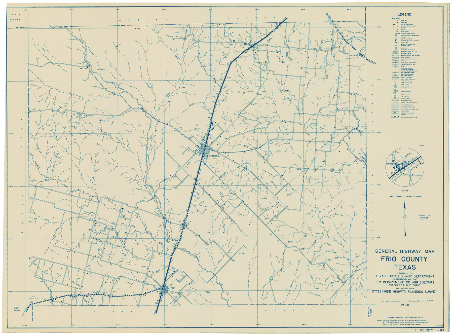
General Highway Map, Frio County, Texas
-
Map/Doc
79095
-
Collection
Texas State Library and Archives
-
Object Dates
1940 (Creation Date)
-
People and Organizations
Texas State Highway Department (Publisher)
-
Counties
Frio
-
Subjects
County
-
Height x Width
18.4 x 24.9 inches
46.7 x 63.3 cm
-
Comments
Prints available courtesy of the Texas State Library and Archives.
More info can be found here: TSLAC Map 04864
Part of: Texas State Library and Archives
General Highway Map, Ector County, Texas

Print $20.00
General Highway Map, Ector County, Texas
1961
Size 18.0 x 24.8 inches
Map/Doc 79451
General Highway Map, San Jacinto County, Texas

Print $20.00
General Highway Map, San Jacinto County, Texas
1940
Size 24.9 x 18.4 inches
Map/Doc 79236
General Highway Map, Leon County, Texas

Print $20.00
General Highway Map, Leon County, Texas
1940
Size 18.3 x 24.9 inches
Map/Doc 79172
General Highway Map, Montgomery County, Texas

Print $20.00
General Highway Map, Montgomery County, Texas
1961
Size 18.2 x 24.6 inches
Map/Doc 79602
General Highway Map, Franklin County, Morris County, Titus County, Camp County

Print $20.00
General Highway Map, Franklin County, Morris County, Titus County, Camp County
1940
Size 18.4 x 25.1 inches
Map/Doc 79040
General Highway Map, Deaf Smith County, Texas

Print $20.00
General Highway Map, Deaf Smith County, Texas
1961
Size 24.5 x 18.1 inches
Map/Doc 79437

General Highway Map, Coke County, Texas

Print $20.00
General Highway Map, Coke County, Texas
1961
Size 18.2 x 24.7 inches
Map/Doc 79411
General Highway Map, McLennan County, Texas

Print $20.00
General Highway Map, McLennan County, Texas
1940
Size 18.3 x 24.6 inches
Map/Doc 79191
General Highway Map, El Paso County, Texas

Print $20.00
General Highway Map, El Paso County, Texas
1961
Size 18.4 x 24.6 inches
Map/Doc 79455
General Highway Map, Cass County, Texas

Print $20.00
General Highway Map, Cass County, Texas
1961
Size 18.3 x 24.7 inches
Map/Doc 79402
General Highway Map, Brewster County, Texas

Print $20.00
General Highway Map, Brewster County, Texas
1961
Size 18.3 x 24.9 inches
Map/Doc 79386
You may also like
Jones County Rolled Sketch 1

Print $20.00
- Digital $50.00
Jones County Rolled Sketch 1
1957
Size 26.1 x 28.3 inches
Map/Doc 6450
Sutton County Sketch File 38

Print $20.00
- Digital $50.00
Sutton County Sketch File 38
1935
Size 18.2 x 28.3 inches
Map/Doc 12388

General Highway Map, Kleberg County, Texas

Print $20.00
General Highway Map, Kleberg County, Texas
1961
Size 24.6 x 18.3 inches
Map/Doc 79559

Reagan County Rolled Sketch 36

Print $20.00
- Digital $50.00
Reagan County Rolled Sketch 36
1960
Size 31.0 x 13.4 inches
Map/Doc 7449
From Citizens of Colorado and Matagorda Counties for the Creation of a New County (Unnamed), August 6, 1840

Print $20.00
From Citizens of Colorado and Matagorda Counties for the Creation of a New County (Unnamed), August 6, 1840
2020
Size 18.5 x 21.7 inches
Map/Doc 96389
Hartley County Working Sketch 6

Print $20.00
- Digital $50.00
Hartley County Working Sketch 6
1971
Size 37.0 x 37.0 inches
Map/Doc 66056
Texas Boundary Line

Print $20.00
- Digital $50.00
Texas Boundary Line
Size 21.3 x 12.0 inches
Map/Doc 92079
El Paso County Rolled Sketch Z55

Print $40.00
- Digital $50.00
El Paso County Rolled Sketch Z55
1915
Size 36.8 x 49.4 inches
Map/Doc 8870
Uvalde County Working Sketch 11

Print $20.00
- Digital $50.00
Uvalde County Working Sketch 11
1943
Size 17.6 x 16.6 inches
Map/Doc 72081
Flight Mission No. DQO-8K, Frame 74, Galveston County

Print $20.00
- Digital $50.00
Flight Mission No. DQO-8K, Frame 74, Galveston County
1952
Size 18.7 x 22.4 inches
Map/Doc 85178