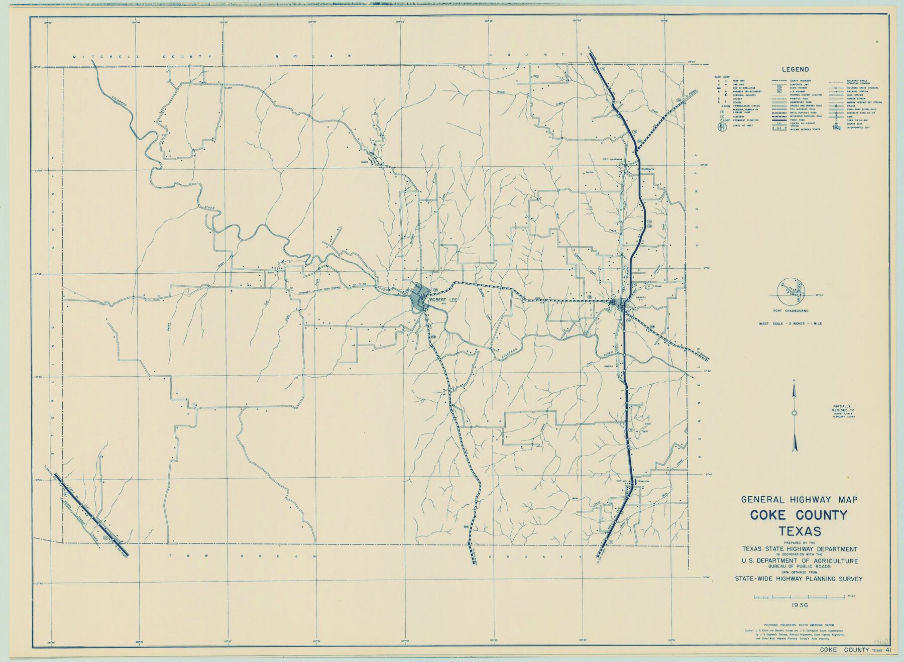
General Highway Map, Coke County, Texas
-
Map/Doc
79049
-
Collection
Texas State Library and Archives
-
Object Dates
1940 (Creation Date)
-
People and Organizations
Texas State Highway Department (Publisher)
-
Counties
Coke
-
Subjects
County
-
Height x Width
18.4 x 25.2 inches
46.7 x 64.0 cm
-
Comments
Prints available courtesy of the Texas State Library and Archives.
More info can be found here: TSLAC Map 04822
Part of: Texas State Library and Archives
General Highway Map, Carson County, Texas

Print $20.00
General Highway Map, Carson County, Texas
1940
Size 18.5 x 25.1 inches
Map/Doc 79041
General Highway Map, Austin County, Texas

Print $20.00
General Highway Map, Austin County, Texas
1961
Size 18.1 x 25.1 inches
Map/Doc 79357
General Highway Map, San Patricio County, Texas

Print $20.00
General Highway Map, San Patricio County, Texas
1940
Size 18.3 x 25.0 inches
Map/Doc 79237
General Highway Map, Aransas County, Texas

Print $20.00
General Highway Map, Aransas County, Texas
1961
Size 18.3 x 25.0 inches
Map/Doc 79352
General Highway Map. Detail of Cities and Towns in Harris County, Texas

Print $20.00
General Highway Map. Detail of Cities and Towns in Harris County, Texas
1939
Size 18.5 x 24.7 inches
Map/Doc 79118
General Highway Map, Baylor County, Texas

Print $20.00
General Highway Map, Baylor County, Texas
1961
Size 18.3 x 24.8 inches
Map/Doc 79363
General Highway Map, Johnson County, Texas

Print $20.00
General Highway Map, Johnson County, Texas
1940
Size 18.3 x 24.8 inches
Map/Doc 79149
General Highway Map, Nacogdoches County, Texas

Print $20.00
General Highway Map, Nacogdoches County, Texas
1940
Size 18.5 x 24.7 inches
Map/Doc 79205
Map of the State of Texas showing the Line and Lands of the Texas and Pacific Railway Reserved and Donated by the State of Texas

Print $20.00
Map of the State of Texas showing the Line and Lands of the Texas and Pacific Railway Reserved and Donated by the State of Texas
1873
Size 20.2 x 25.1 inches
Map/Doc 76317
General Highway Map, Madison County, Texas

Print $20.00
General Highway Map, Madison County, Texas
1940
Size 18.3 x 24.5 inches
Map/Doc 79183
General Highway Map, Erath County, Texas

Print $20.00
General Highway Map, Erath County, Texas
1940
Size 24.7 x 18.4 inches
Map/Doc 79086
General Highway Map, Orange County, Texas

Print $20.00
General Highway Map, Orange County, Texas
1940
Size 18.3 x 24.5 inches
Map/Doc 79212
You may also like
Map of Texas from the most recent authorities

Print $20.00
- Digital $50.00
Map of Texas from the most recent authorities
1845
Size 14.1 x 17.9 inches
Map/Doc 97280
Rusk County Sketch File 47

Print $8.00
Rusk County Sketch File 47
Size 12.7 x 7.9 inches
Map/Doc 35597
Glasscock County Working Sketch 2

Print $20.00
- Digital $50.00
Glasscock County Working Sketch 2
Size 32.0 x 28.0 inches
Map/Doc 63175
[D. & S. E. Surs., G. C. & S. F. Blk. 9 west of University Land Blks. 49 and 50]
![90308, [D. & S. E. Surs., G. C. & S. F. Blk. 9 west of University Land Blks. 49 and 50], Twichell Survey Records](https://historictexasmaps.com/wmedia_w700/maps/90308-1.tif.jpg)
Print $3.00
- Digital $50.00
[D. & S. E. Surs., G. C. & S. F. Blk. 9 west of University Land Blks. 49 and 50]
Size 11.3 x 15.4 inches
Map/Doc 90308
[Sketch Between Hemphill County and Oklahoma]
![89670, [Sketch Between Hemphill County and Oklahoma], Twichell Survey Records](https://historictexasmaps.com/wmedia_w700/maps/89670-1.tif.jpg)
Print $40.00
- Digital $50.00
[Sketch Between Hemphill County and Oklahoma]
Size 60.4 x 7.8 inches
Map/Doc 89670
Galveston County Rolled Sketch 46A

Print $20.00
- Digital $50.00
Galveston County Rolled Sketch 46A
2000
Size 24.9 x 37.6 inches
Map/Doc 5982

[Sketch showing School Lands]
![90449, [Sketch showing School Lands], Twichell Survey Records](https://historictexasmaps.com/wmedia_w700/maps/90449-1.tif.jpg)
Print $20.00
- Digital $50.00
[Sketch showing School Lands]
Size 25.4 x 12.5 inches
Map/Doc 90449
Comal County Boundary File 1

Print $5.00
- Digital $50.00
Comal County Boundary File 1
Size 12.9 x 11.0 inches
Map/Doc 51776
El Paso County Sketch File 1

Print $48.00
- Digital $50.00
El Paso County Sketch File 1
1849
Size 8.9 x 8.2 inches
Map/Doc 21883
Map of Shackelford County

Print $20.00
- Digital $50.00
Map of Shackelford County
1901
Size 26.5 x 21.9 inches
Map/Doc 63031
Blanco County Rolled Sketch 13

Print $20.00
- Digital $50.00
Blanco County Rolled Sketch 13
Size 14.2 x 28.9 inches
Map/Doc 5149