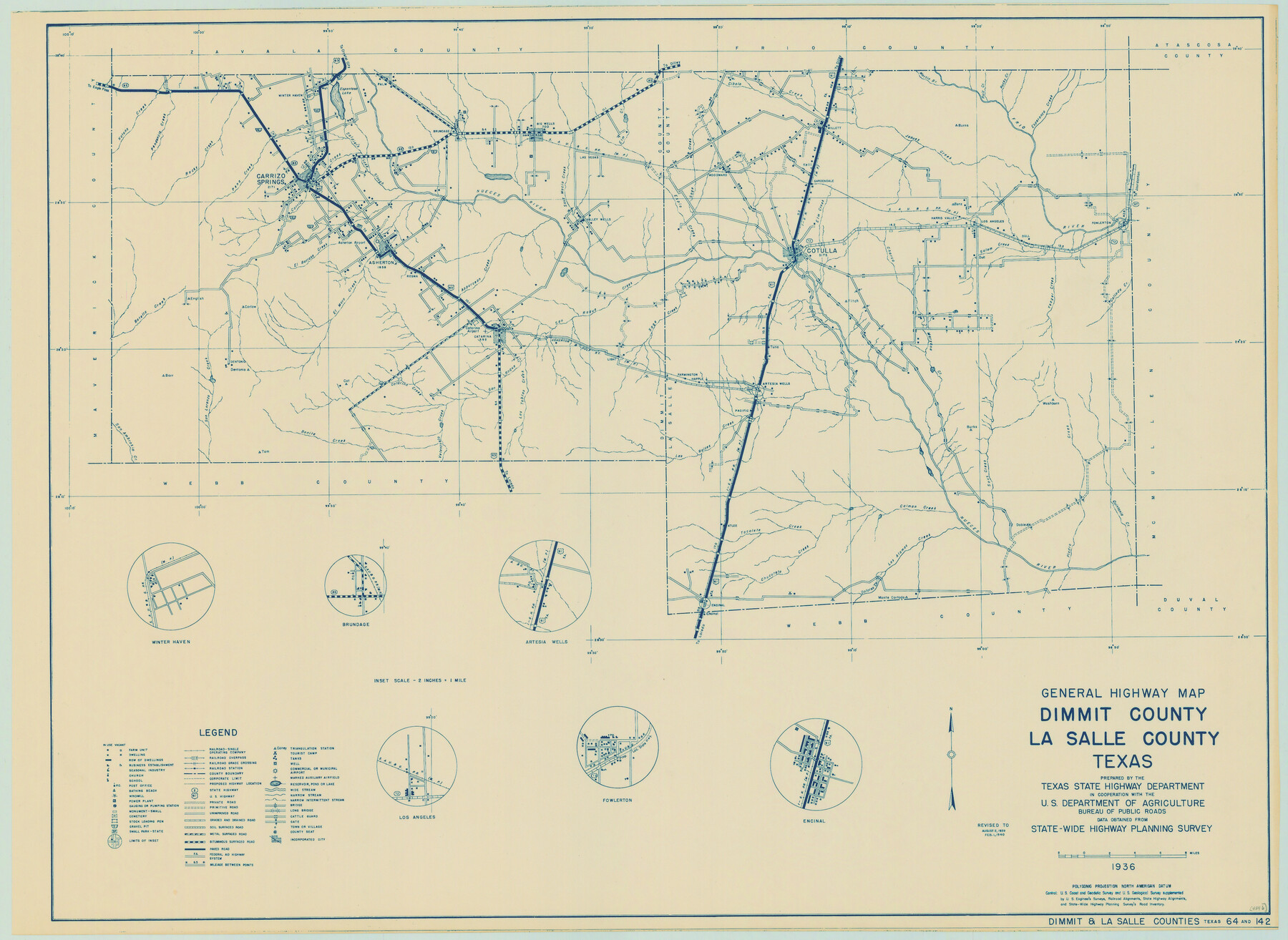
General Highway Map, Dimmit County, La Salle County, Texas
-
Map/Doc
79077
-
Collection
Texas State Library and Archives
-
Object Dates
1940 (Creation Date)
-
People and Organizations
Texas State Highway Department (Publisher)
-
Counties
Dimmit La Salle
-
Subjects
County
-
Height x Width
18.4 x 25.2 inches
46.7 x 64.0 cm
-
Comments
Prints available courtesy of the Texas State Library and Archives.
More info can be found here: TSLAC Map 04846
Part of: Texas State Library and Archives
General Highway Map, Comal County, Texas

Print $20.00
General Highway Map, Comal County, Texas
1940
Size 18.2 x 25.2 inches
Map/Doc 79055
Carte Reduite des Costes de la Louisiane et de la Floride

Print $20.00
Carte Reduite des Costes de la Louisiane et de la Floride
1764
Size 23.3 x 35.1 inches
Map/Doc 79295
Classification of Land Uses in Texas by Counties

Print $20.00
Classification of Land Uses in Texas by Counties
1935
Size 35.6 x 46.1 inches
Map/Doc 76310
General Highway Map, Collin County, Texas

Print $20.00
General Highway Map, Collin County, Texas
1939
Size 18.6 x 25.0 inches
Map/Doc 79052
Map of the Texas and Pacific Railway and Connections

Print $20.00
Map of the Texas and Pacific Railway and Connections
1897
Size 19.3 x 24.4 inches
Map/Doc 79328
General Highway Map, Lipscomb County, Texas

Print $20.00
General Highway Map, Lipscomb County, Texas
1961
Size 18.1 x 24.6 inches
Map/Doc 79573
General Highway Map, Angelina County, Texas

Print $20.00
General Highway Map, Angelina County, Texas
1961
Size 25.1 x 18.4 inches
Map/Doc 79350
General Highway Map, Carson County, Texas

Print $20.00
General Highway Map, Carson County, Texas
1961
Size 18.2 x 24.9 inches
Map/Doc 79401
General Highway Map, Houston County, Texas

Print $20.00
General Highway Map, Houston County, Texas
1940
Size 18.3 x 24.8 inches
Map/Doc 79133
General Highway Map, Winkler County, Texas

Print $20.00
General Highway Map, Winkler County, Texas
1961
Size 18.2 x 24.8 inches
Map/Doc 79717
Missouri, Kansas, and Texas Railway

Print $20.00
Missouri, Kansas, and Texas Railway
1878
Size 16.5 x 12.2 inches
Map/Doc 76188
General Highway Map, Lampasas County, Texas

Print $20.00
General Highway Map, Lampasas County, Texas
1961
Size 18.2 x 24.7 inches
Map/Doc 79563
You may also like
Flight Mission No. CRC-4R, Frame 95, Chambers County

Print $20.00
- Digital $50.00
Flight Mission No. CRC-4R, Frame 95, Chambers County
1956
Size 18.6 x 22.3 inches
Map/Doc 84892
Flight Mission No. CLL-1N, Frame 196, Willacy County

Print $20.00
- Digital $50.00
Flight Mission No. CLL-1N, Frame 196, Willacy County
1954
Size 18.5 x 22.2 inches
Map/Doc 87066
Potter County Working Sketch 13

Print $20.00
- Digital $50.00
Potter County Working Sketch 13
1980
Size 19.5 x 26.9 inches
Map/Doc 71673
Van Zandt County

Print $20.00
- Digital $50.00
Van Zandt County
1896
Size 26.1 x 22.4 inches
Map/Doc 4114
Upshur County Sketch File 21

Print $78.00
- Digital $50.00
Upshur County Sketch File 21
2000
Size 36.6 x 24.9 inches
Map/Doc 12508
Cooke County Working Sketch 32

Print $20.00
- Digital $50.00
Cooke County Working Sketch 32
1982
Size 19.0 x 14.8 inches
Map/Doc 68269
Mexican Boundary B. - Extract from the Treaty Map of Disturnell of 1847 referred to in Col. Graham's report to the Hon. The Secretary of the Interior of Aug. 16th, 1851

Print $20.00
- Digital $50.00
Mexican Boundary B. - Extract from the Treaty Map of Disturnell of 1847 referred to in Col. Graham's report to the Hon. The Secretary of the Interior of Aug. 16th, 1851
Size 10.1 x 16.5 inches
Map/Doc 96525
Gregg County Sketch File 6

Print $10.00
- Digital $50.00
Gregg County Sketch File 6
1931
Size 11.2 x 8.8 inches
Map/Doc 24577
General Highway Map, La Salle County, Texas

Print $20.00
General Highway Map, La Salle County, Texas
1961
Size 18.2 x 24.8 inches
Map/Doc 79565
Blanco County Boundary File 10

Print $26.00
- Digital $50.00
Blanco County Boundary File 10
Size 8.9 x 7.6 inches
Map/Doc 50576
The City of Austin and Suburbs

Print $40.00
- Digital $50.00
The City of Austin and Suburbs
1919
Size 120.7 x 73.5 inches
Map/Doc 2204
Map of Haskell County

Print $20.00
- Digital $50.00
Map of Haskell County
1899
Size 39.8 x 35.7 inches
Map/Doc 4974