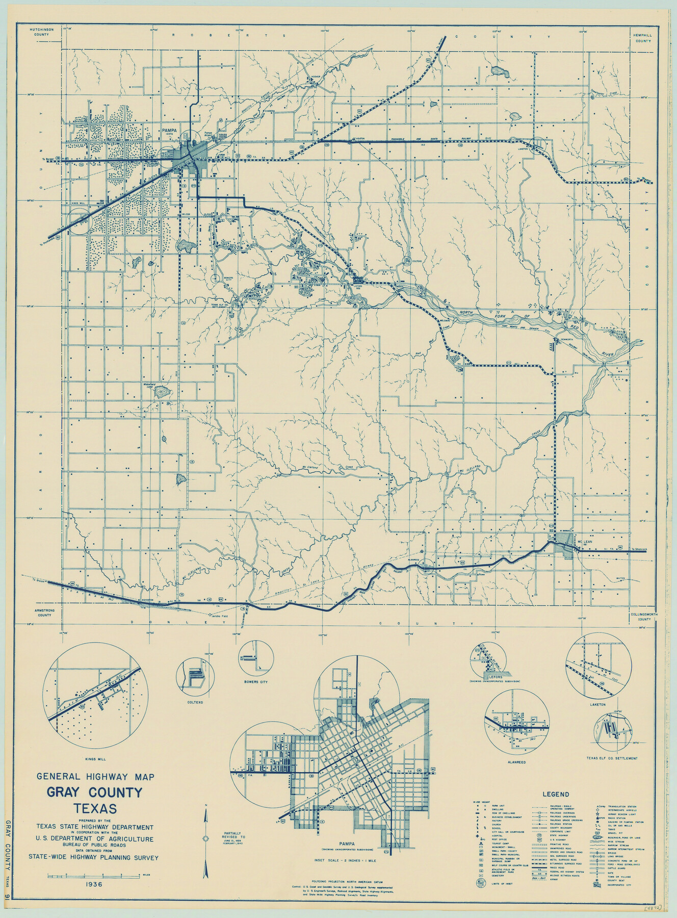
General Highway Map, Gray County, Texas
-
Map/Doc
79103
-
Collection
Texas State Library and Archives
-
Object Dates
1940 (Creation Date)
-
People and Organizations
Texas State Highway Department (Publisher)
-
Counties
Gray
-
Subjects
County
-
Height x Width
25.0 x 18.4 inches
63.5 x 46.7 cm
-
Comments
Prints available courtesy of the Texas State Library and Archives.
More info can be found here: TSLAC Map 04872
Part of: Texas State Library and Archives
General Highway Map, Cameron County, Texas

Print $20.00
General Highway Map, Cameron County, Texas
1940
Size 18.4 x 25.3 inches
Map/Doc 79038
General Highway Map, Cherokee County, Texas

Print $20.00
General Highway Map, Cherokee County, Texas
1939
Size 25.2 x 18.5 inches
Map/Doc 79045
General Highway Map, Hidalgo County, Texas

Print $20.00
General Highway Map, Hidalgo County, Texas
1961
Size 18.1 x 24.9 inches
Map/Doc 79518
Texas and part of Mexico and the United States showing the Route of the First Santa Fe Expedition

Print $20.00
Texas and part of Mexico and the United States showing the Route of the First Santa Fe Expedition
1844
Size 20.3 x 15.8 inches
Map/Doc 79730
General Highway Map, Wharton County, Texas

Print $20.00
General Highway Map, Wharton County, Texas
1940
Size 18.5 x 24.9 inches
Map/Doc 79274
General Highway Map, Llano County, Texas

Print $20.00
General Highway Map, Llano County, Texas
1961
Size 18.2 x 24.6 inches
Map/Doc 79576
General Highway Map, Palo Pinto County, Texas

Print $20.00
General Highway Map, Palo Pinto County, Texas
1940
Size 18.2 x 24.6 inches
Map/Doc 79213
General Highway Map, Johnson County, Texas

Print $20.00
General Highway Map, Johnson County, Texas
1961
Size 18.2 x 24.8 inches
Map/Doc 79545
General Highway Map, Detail of Cities and Towns in Delta County, Hopkins County [Cooper and vicinity]
![79440, General Highway Map, Detail of Cities and Towns in Delta County, Hopkins County [Cooper and vicinity], Texas State Library and Archives](https://historictexasmaps.com/wmedia_w700/maps/79440.tif.jpg)
Print $20.00
General Highway Map, Detail of Cities and Towns in Delta County, Hopkins County [Cooper and vicinity]
1961
Size 18.2 x 24.4 inches
Map/Doc 79440
General Highway Map, Garza County, Texas

Print $20.00
General Highway Map, Garza County, Texas
1961
Size 18.2 x 24.6 inches
Map/Doc 79478
General Highway Map, Mason County, Texas

Print $20.00
General Highway Map, Mason County, Texas
1940
Size 18.2 x 24.5 inches
Map/Doc 79186
Topographic Map of Texas and Oklahoma Boundary, Fort Augur Area

Print $20.00
Topographic Map of Texas and Oklahoma Boundary, Fort Augur Area
1924
Size 22.1 x 38.3 inches
Map/Doc 79752
You may also like
Aransas County Sketch File 15a

Print $14.00
- Digital $50.00
Aransas County Sketch File 15a
Size 11.0 x 8.4 inches
Map/Doc 13136
Montgomery County Working Sketch 60

Print $20.00
- Digital $50.00
Montgomery County Working Sketch 60
1963
Size 24.3 x 42.7 inches
Map/Doc 71167
[Bastrop County School Land Leagues 313 and 314, Thos. H. Cosby League 315 and El Paso County School Land League 316 and surrounding surveys]
![90819, [Bastrop County School Land Leagues 313 and 314, Thos. H. Cosby League 315 and El Paso County School Land League 316 and surrounding surveys], Twichell Survey Records](https://historictexasmaps.com/wmedia_w700/maps/90819-2.tif.jpg)
Print $3.00
- Digital $50.00
[Bastrop County School Land Leagues 313 and 314, Thos. H. Cosby League 315 and El Paso County School Land League 316 and surrounding surveys]
1898
Size 10.5 x 12.6 inches
Map/Doc 90819
Coleman County Sketch File 9

Print $24.00
- Digital $50.00
Coleman County Sketch File 9
1859
Size 12.4 x 8.2 inches
Map/Doc 18675
Terrell County Working Sketch Graphic index - sheet B

Print $20.00
- Digital $50.00
Terrell County Working Sketch Graphic index - sheet B
1931
Size 47.7 x 39.6 inches
Map/Doc 76711
Plat of Re-survey Section 8, Block 66 1/2, Public School Land

Print $20.00
- Digital $50.00
Plat of Re-survey Section 8, Block 66 1/2, Public School Land
1972
Size 15.9 x 38.8 inches
Map/Doc 2080
Jasper County Working Sketch 8

Print $20.00
- Digital $50.00
Jasper County Working Sketch 8
1915
Size 20.1 x 31.4 inches
Map/Doc 66470
Map of Haskell County

Print $20.00
- Digital $50.00
Map of Haskell County
1899
Size 39.8 x 35.7 inches
Map/Doc 4974

Working Sketch, Cottle County

Print $20.00
- Digital $50.00
Working Sketch, Cottle County
1916
Size 26.0 x 28.9 inches
Map/Doc 4435
Smith's Atlas designed to accompany the Geography

Print $352.00
- Digital $50.00
Smith's Atlas designed to accompany the Geography
1850
Size 12.2 x 10.0 inches
Map/Doc 93881
Nueva Hispania Tabula Nova

Print $20.00
- Digital $50.00
Nueva Hispania Tabula Nova
1561
Size 9.4 x 12.3 inches
Map/Doc 93796