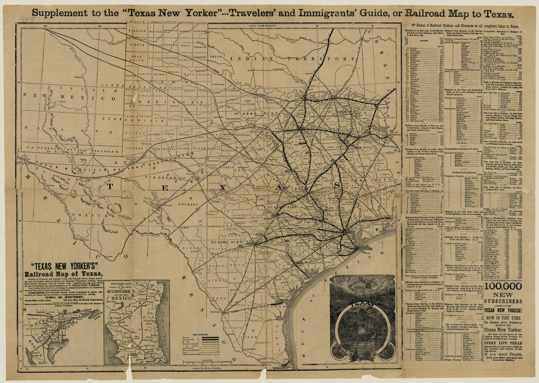
"Texas New Yorker's" Railroad Map of Texas
- 
                          Map/Doc76210
- 
                            CollectionTexas State Library and Archives
- 
                            Object Dates1874 (Creation Date)
- 
                            People and OrganizationsTexas New Yorker (Publisher)
- 
                            SubjectsRailroads State of Texas
- 
                            Height x Width22.8 x 32.3 inches57.9 x 82.0 cm
- 
                            CommentsPrints available courtesy of the Texas State Library and Archives.
 More info can be found here: TSLAC Map 00945
Part of: Texas State Library and Archives
            General Highway Map, Shackelford County, Texas


                                            Print $20.00                    
                                    
                General Highway Map, Shackelford County, Texas
1940
Size 18.4 x 24.8 inches
                                Map/Doc 79241
            
            General Highway Map, Sherman County, Texas


                                            Print $20.00                    
                                    
                General Highway Map, Sherman County, Texas
1940
Size 18.2 x 24.9 inches
                                Map/Doc 79243
            
            General Highway Map, Harris County, Texas


                                            Print $20.00                    
                                    
                General Highway Map, Harris County, Texas
1961
Size 24.9 x 18.0 inches
                                Map/Doc 79502
            
            General Highway Map, Newton County, Texas


                                            Print $20.00                    
                                    
                General Highway Map, Newton County, Texas
1961
Size 19.3 x 25.0 inches
                                Map/Doc 79612
            
            General Highway Map, Polk County, Texas


                                            Print $20.00                    
                                    
                General Highway Map, Polk County, Texas
1961
Size 18.1 x 24.5 inches
                                Map/Doc 79630
            
            General Highway Map, Matagorda County, Texas


                                            Print $20.00                    
                                    
                General Highway Map, Matagorda County, Texas
1961
Size 24.7 x 18.2 inches
                                Map/Doc 79586
            
            General Highway Map, Kleberg County, Texas


                                            Print $20.00                    
                                    
                General Highway Map, Kleberg County, Texas
1961
Size 24.6 x 18.3 inches
                                Map/Doc 79559
            
            General Highway Map, Delta County, Hopkins County, Texas


                                            Print $20.00                    
                                    
                General Highway Map, Delta County, Hopkins County, Texas
1940
Size 25.2 x 18.5 inches
                                Map/Doc 79073
            
            General Highway Map, Gonzales County, Texas


                                            Print $20.00                    
                                    
                General Highway Map, Gonzales County, Texas
1940
Size 18.6 x 25.0 inches
                                Map/Doc 79102
            
            General Highway Map, Deaf Smith County, Texas


                                            Print $20.00                    
                                    
                General Highway Map, Deaf Smith County, Texas
1961
Size 24.5 x 18.1 inches
                                Map/Doc 79437
            
            General Highway Map, Borden County, Texas


                                            Print $20.00                    
                                    
                General Highway Map, Borden County, Texas
1961
Size 18.3 x 25.0 inches
                                Map/Doc 79377
            
            General Highway Map, San Patricio County, Texas


                                            Print $20.00                    
                                    
                General Highway Map, San Patricio County, Texas
1940
Size 18.3 x 25.0 inches
                                Map/Doc 79237
            You may also like
            Dickens County Sketch File N


                                            Print $4.00                    
                                             -                         Digital $50.00                                    
                Dickens County Sketch File N
1903
Size 8.3 x 13.6 inches
                                Map/Doc 20942
            
            [Plat and field notes of 3.107 acre tract for Clement Cove Harbor Company]
            
                                    ![60397, [Plat and field notes of 3.107 acre tract for Clement Cove Harbor Company], General Map Collection](https://historictexasmaps.com/wmedia_w700/maps/60397-1.tif.jpg) 


    ![60397, [Plat and field notes of 3.107 acre tract for Clement Cove Harbor Company], General Map Collection](https://historictexasmaps.com/wmedia_w700/maps/60397-1.tif.jpg) 
                                
            
                                            Print $20.00                    
                                             -                         Digital $50.00                                    
                [Plat and field notes of 3.107 acre tract for Clement Cove Harbor Company]
1987
Size 24.2 x 36.5 inches
                                Map/Doc 60397
            
            Kleberg County Boundary File 1


                                            Print $10.00                    
                                             -                         Digital $50.00                                    
                Kleberg County Boundary File 1
Size 9.3 x 5.9 inches
                                Map/Doc 64961
            
            Potter County


                                            Print $20.00                    
                                             -                         Digital $50.00                                    
                Potter County
1909
Size 47.5 x 40.8 inches
                                Map/Doc 66984
            
            Newton County Sketch File 23


                                            Print $4.00                    
                                             -                         Digital $50.00                                    
                Newton County Sketch File 23
1855
Size 10.1 x 8.0 inches
                                Map/Doc 32403
            
            Zavala County Sketch File 4


                                            Print $20.00                    
                                             -                         Digital $50.00                                    
                Zavala County Sketch File 4
1852
Size 17.7 x 14.7 inches
                                Map/Doc 12726
            
            Angelina County Working Sketch 14


                                            Print $20.00                    
                                             -                         Digital $50.00                                    
                Angelina County Working Sketch 14
1935
Size 29.6 x 34.9 inches
                                Map/Doc 67095
            
            Carson County


                                            Print $20.00                    
                                             -                         Digital $50.00                                    
                Carson County
1932
Size 42.0 x 38.5 inches
                                Map/Doc 73100
            
            Plat of the Resubdivision of the Abandoned Townsite of Eschiti, Oklahoma


                                            Print $4.00                    
                                             -                         Digital $50.00                                    
                Plat of the Resubdivision of the Abandoned Townsite of Eschiti, Oklahoma
1907
Size 18.1 x 24.3 inches
                                Map/Doc 75150
            
            PSL Field Notes for Blocks B14 and B16 in Crane and Ector Counties, Blocks B18 and B20 in Crane and Ward Counties, and Blocks B17, B21, B22, B23, B24, B25, and B26 in Crane County


            PSL Field Notes for Blocks B14 and B16 in Crane and Ector Counties, Blocks B18 and B20 in Crane and Ward Counties, and Blocks B17, B21, B22, B23, B24, B25, and B26 in Crane County
Map/Doc 81646
            
            Intracoastal Waterway - Gibbstown to Port Arthur


                                            Print $20.00                    
                                             -                         Digital $50.00                                    
                Intracoastal Waterway - Gibbstown to Port Arthur
1957
Size 27.1 x 38.8 inches
                                Map/Doc 69829
            
            Webb County Working Sketch 14


                                            Print $20.00                    
                                             -                         Digital $50.00                                    
                Webb County Working Sketch 14
1923
Size 19.3 x 32.2 inches
                                Map/Doc 72379
            