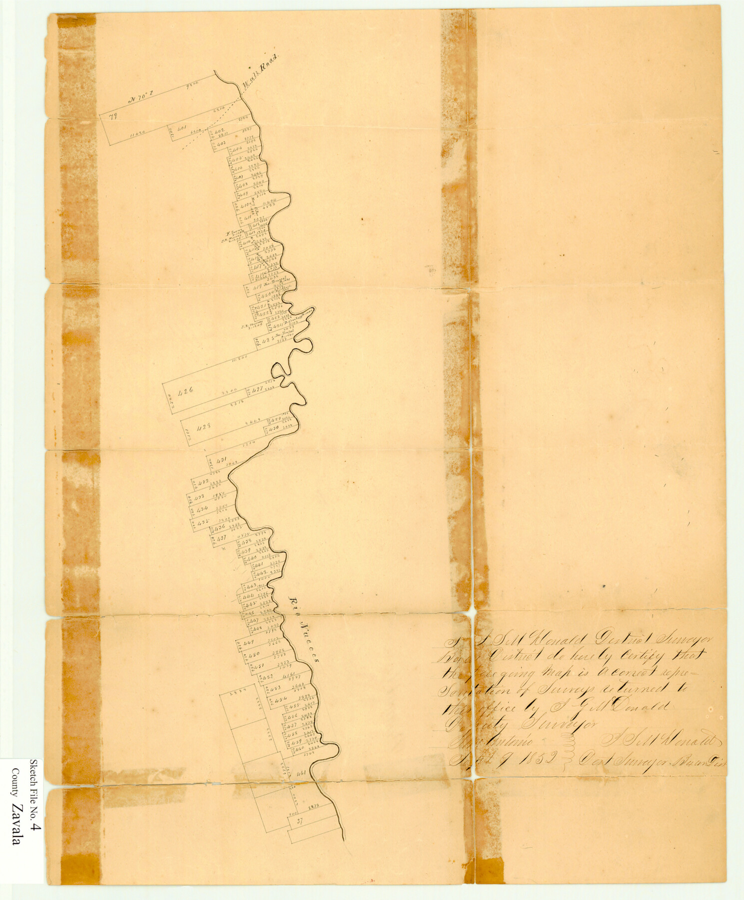
Zavala County Sketch File 4
[Sketch of surveys along the west bank of the Nueces River north of Crystal City]
- 
                          Map/Doc
12726
 - 
                            Collection
General Map Collection
 - 
                            Object Dates
9/9/1852 (Creation Date)
 - 
                            People and Organizations
J.S. McDonald (Surveyor/Engineer)
 - 
                            Counties
Zavala
 - 
                            Subjects
Surveying Sketch File
 - 
                            Height x Width
17.7 x 14.7 inches
45.0 x 37.3 cm
 - 
                            Medium
paper, manuscript
 - 
                            Features
Wall Road
Rio Nueces
 
Part of: General Map Collection
            Red River County Sketch File 1


                                            Print $4.00                    
                                             -                         Digital $50.00                                    
                Red River County Sketch File 1
Size 8.4 x 12.8 inches
                                Map/Doc 35091
            
            Matagorda County Sketch File 14


                                            Print $40.00                    
                                             -                         Digital $50.00                                    
                Matagorda County Sketch File 14
Size 13.5 x 14.8 inches
                                Map/Doc 30772
            
            Fayette County


                                            Print $40.00                    
                                             -                         Digital $50.00                                    
                Fayette County
1978
Size 43.6 x 56.1 inches
                                Map/Doc 95496
            
            Traced from Genl. Arista's map captured by the American Army under Genl. Taylor at Resaca de la Palma 9th May '46 and presented to James K. Polk, President U. States


                                            Print $20.00                    
                                             -                         Digital $50.00                                    
                Traced from Genl. Arista's map captured by the American Army under Genl. Taylor at Resaca de la Palma 9th May '46 and presented to James K. Polk, President U. States
1846
Size 18.2 x 27.3 inches
                                Map/Doc 73060
            
            Real County Working Sketch 69


                                            Print $20.00                    
                                             -                         Digital $50.00                                    
                Real County Working Sketch 69
1942
Size 42.4 x 35.4 inches
                                Map/Doc 71961
            
            Jasper County Working Sketch 9


                                            Print $20.00                    
                                             -                         Digital $50.00                                    
                Jasper County Working Sketch 9
1917
Size 21.0 x 14.3 inches
                                Map/Doc 66471
            
            Terrell County Rolled Sketch 44


                                            Print $20.00                    
                                             -                         Digital $50.00                                    
                Terrell County Rolled Sketch 44
1952
Size 18.3 x 22.9 inches
                                Map/Doc 7947
            
            Hudspeth County Sketch File 7


                                            Print $6.00                    
                                             -                         Digital $50.00                                    
                Hudspeth County Sketch File 7
1900
Size 14.2 x 8.7 inches
                                Map/Doc 26892
            
            Uvalde County Boundary File 1a


                                            Print $12.00                    
                                             -                         Digital $50.00                                    
                Uvalde County Boundary File 1a
Size 14.5 x 8.9 inches
                                Map/Doc 59551
            
            Hays County Working Sketch 9


                                            Print $40.00                    
                                             -                         Digital $50.00                                    
                Hays County Working Sketch 9
1949
Size 22.8 x 50.5 inches
                                Map/Doc 66083
            
            Jefferson County Rolled Sketch 39


                                            Print $20.00                    
                                             -                         Digital $50.00                                    
                Jefferson County Rolled Sketch 39
1885
Size 31.6 x 34.3 inches
                                Map/Doc 9300
            You may also like
            Controlled Mosaic by Jack Amman Photogrammetric Engineers, Inc - Sheet 41


                                            Print $20.00                    
                                             -                         Digital $50.00                                    
                Controlled Mosaic by Jack Amman Photogrammetric Engineers, Inc - Sheet 41
1954
Size 20.0 x 24.0 inches
                                Map/Doc 83497
            
            Official Map of the Highway System of Texas


                                            Print $20.00                    
                                             -                         Digital $50.00                                    
                Official Map of the Highway System of Texas
1936
Size 27.5 x 33.4 inches
                                Map/Doc 83599
            
            Where Did Columbus Discover America?


            Where Did Columbus Discover America?
1986
Size 14.7 x 20.6 inches
                                Map/Doc 96837
            
            Reagan County Working Sketch 42


                                            Print $20.00                    
                                             -                         Digital $50.00                                    
                Reagan County Working Sketch 42
1973
Size 19.9 x 37.0 inches
                                Map/Doc 71884
            
            Flight Mission No. DCL-6C, Frame 29, Kenedy County


                                            Print $20.00                    
                                             -                         Digital $50.00                                    
                Flight Mission No. DCL-6C, Frame 29, Kenedy County
1943
Size 18.6 x 22.4 inches
                                Map/Doc 85886
            
            Terry County Rolled Sketch 10


                                            Print $20.00                    
                                             -                         Digital $50.00                                    
                Terry County Rolled Sketch 10
2001
Size 25.2 x 23.8 inches
                                Map/Doc 76414
            
            Flight Mission No. CGI-3N, Frame 100, Cameron County


                                            Print $20.00                    
                                             -                         Digital $50.00                                    
                Flight Mission No. CGI-3N, Frame 100, Cameron County
1954
Size 18.6 x 22.3 inches
                                Map/Doc 84580
            
            Llano County Working Sketch 15


                                            Print $20.00                    
                                             -                         Digital $50.00                                    
                Llano County Working Sketch 15
2007
Size 46.0 x 26.2 inches
                                Map/Doc 87372
            
            Culberson County Working Sketch 25


                                            Print $40.00                    
                                             -                         Digital $50.00                                    
                Culberson County Working Sketch 25
1951
Size 36.9 x 52.5 inches
                                Map/Doc 62343
            
            Il Cuscho Citta Principale Della Provincia del Peru


                                            Print $20.00                    
                                             -                         Digital $50.00                                    
                Il Cuscho Citta Principale Della Provincia del Peru
1592
Size 12.3 x 15.4 inches
                                Map/Doc 97026
            
            Bee County Working Sketch 28


                                            Print $20.00                    
                                             -                         Digital $50.00                                    
                Bee County Working Sketch 28
1988
Size 48.2 x 34.6 inches
                                Map/Doc 67278
            
            Map of State University Land, Pecos County, Texas


                                            Print $20.00                    
                                             -                         Digital $50.00                                    
                Map of State University Land, Pecos County, Texas
1929
Size 28.4 x 22.7 inches
                                Map/Doc 91631