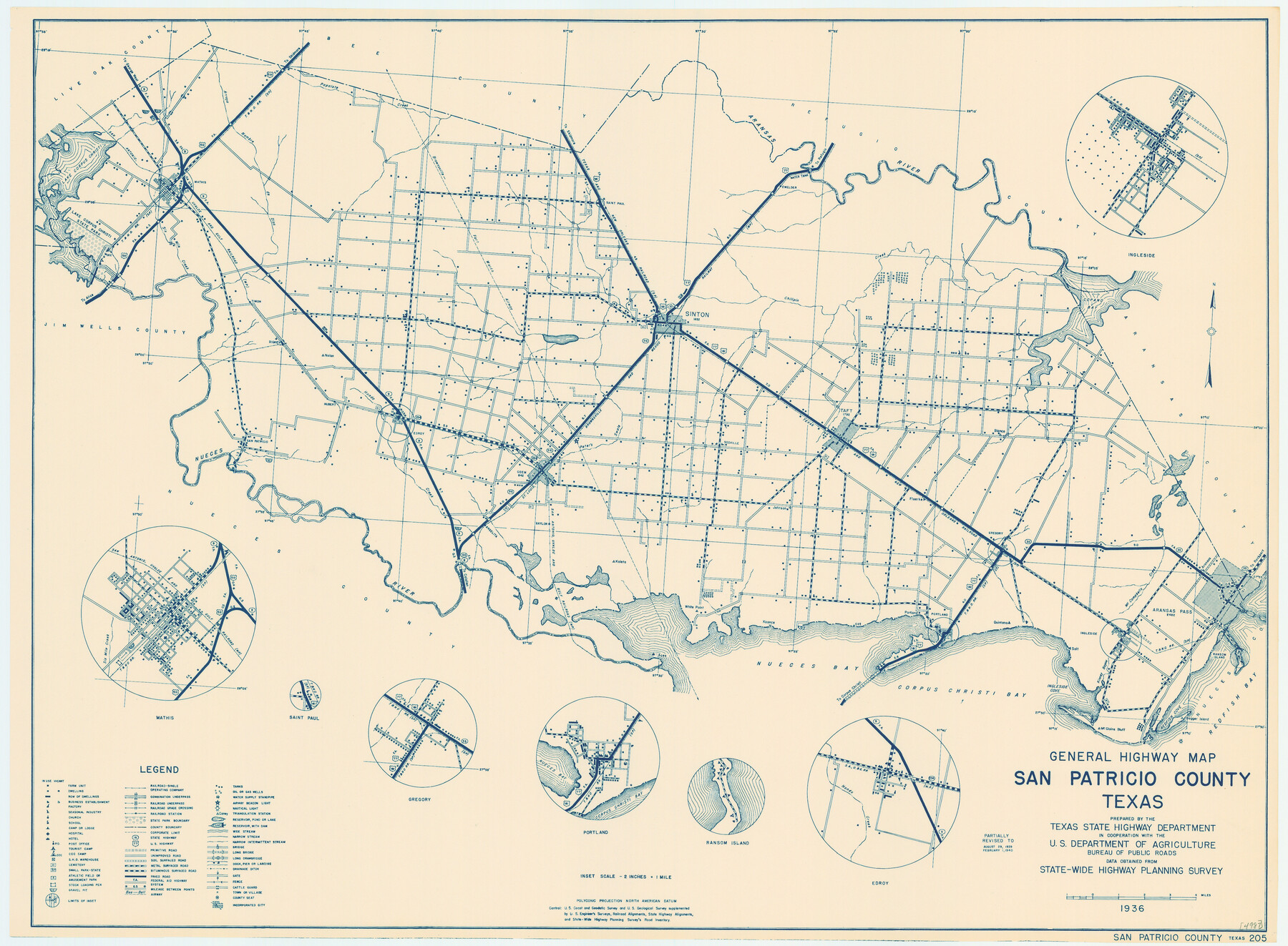
General Highway Map, San Patricio County, Texas
-
Map/Doc
79237
-
Collection
Texas State Library and Archives
-
Object Dates
1940 (Creation Date)
-
People and Organizations
Texas State Highway Department (Publisher)
-
Counties
San Patricio
-
Subjects
County
-
Height x Width
18.3 x 25.0 inches
46.5 x 63.5 cm
-
Comments
Prints available courtesy of the Texas State Library and Archives.
More info can be found here: TSLAC Map 04987
Part of: Texas State Library and Archives
General Highway Map. Detail of Cities and Towns in Tyler County, Texas [Woodville and vicinity]
![79691, General Highway Map. Detail of Cities and Towns in Tyler County, Texas [Woodville and vicinity], Texas State Library and Archives](https://historictexasmaps.com/wmedia_w700/maps/79691.tif.jpg)
Print $20.00
General Highway Map. Detail of Cities and Towns in Tyler County, Texas [Woodville and vicinity]
1961
Size 18.1 x 24.8 inches
Map/Doc 79691
Oil and Gas Fields in the State of Texas

Print $40.00
Oil and Gas Fields in the State of Texas
1927
Size 58.0 x 38.0 inches
Map/Doc 76304
General Highway Map, Live Oak County, Texas

Print $20.00
General Highway Map, Live Oak County, Texas
1961
Size 18.2 x 24.8 inches
Map/Doc 79574
[General Highway Map of] Bexar County, Sheet 1 of 2
![76288, [General Highway Map of] Bexar County, Sheet 1 of 2, Texas State Library and Archives](https://historictexasmaps.com/wmedia_w700/maps/76288.tif.jpg)
Print $20.00
[General Highway Map of] Bexar County, Sheet 1 of 2
1940
Size 18.5 x 25.1 inches
Map/Doc 76288
General Highway Map, Goliad County, Texas

Print $20.00
General Highway Map, Goliad County, Texas
1961
Size 18.2 x 24.7 inches
Map/Doc 79481
General Highway Map, Hall County, Texas

Print $20.00
General Highway Map, Hall County, Texas
1961
Size 18.2 x 24.6 inches
Map/Doc 79495
Topographic Map of Texas and Oklahoma Boundary, Fort Augur Area

Print $20.00
Topographic Map of Texas and Oklahoma Boundary, Fort Augur Area
1924
Size 20.3 x 33.0 inches
Map/Doc 79753
Map of the River Sabine from its Mouth on the Gulf of Mexico in the Sea to Logan's Ferry in Latitude 31° 58' 25" North

Print $20.00
Map of the River Sabine from its Mouth on the Gulf of Mexico in the Sea to Logan's Ferry in Latitude 31° 58' 25" North
1840
Size 35.5 x 9.1 inches
Map/Doc 79294
General Highway Map, Wilbarger County, Texas

Print $20.00
General Highway Map, Wilbarger County, Texas
1940
Size 24.7 x 18.1 inches
Map/Doc 79278
General Highway Map, Potter County, Texas

Print $20.00
General Highway Map, Potter County, Texas
1961
Size 24.5 x 18.2 inches
Map/Doc 79631
General Highway Map. Detail of Cities and Towns in Lubbock County, Texas [Lubbock and vicinity]
![79181, General Highway Map. Detail of Cities and Towns in Lubbock County, Texas [Lubbock and vicinity], Texas State Library and Archives](https://historictexasmaps.com/wmedia_w700/maps/79181.tif.jpg)
Print $20.00
General Highway Map. Detail of Cities and Towns in Lubbock County, Texas [Lubbock and vicinity]
1940
Size 18.3 x 24.8 inches
Map/Doc 79181
Map of Texas with Parts of the Adjoining States

Print $20.00
Map of Texas with Parts of the Adjoining States
1833
Size 29.3 x 23.3 inches
Map/Doc 79740
You may also like
Duval County Rolled Sketch 38

Print $20.00
- Digital $50.00
Duval County Rolled Sketch 38
1937
Size 22.6 x 16.1 inches
Map/Doc 5755
Working Sketch in Wichita County

Print $20.00
- Digital $50.00
Working Sketch in Wichita County
1919
Size 14.1 x 27.0 inches
Map/Doc 91993
Oldham County Boundary File 1b

Print $48.00
- Digital $50.00
Oldham County Boundary File 1b
Size 14.0 x 8.5 inches
Map/Doc 57747
Colorado River, Hungerford Sheet

Print $6.00
- Digital $50.00
Colorado River, Hungerford Sheet
1941
Size 24.1 x 35.4 inches
Map/Doc 65309
Houston County Rolled Sketch 11

Print $20.00
- Digital $50.00
Houston County Rolled Sketch 11
1988
Size 29.9 x 22.9 inches
Map/Doc 6231
Fort Bend County Sketch File 17 1/2

Print $52.00
- Digital $50.00
Fort Bend County Sketch File 17 1/2
1896
Size 11.2 x 8.7 inches
Map/Doc 22934
Edwards County Sketch File 21

Print $6.00
- Digital $50.00
Edwards County Sketch File 21
1889
Size 12.9 x 8.5 inches
Map/Doc 21740
[Juan Jose Balli Survey, Kenedy County, Texas]
![[Juan Jose Balli Survey, Kenedy County, Texas]](https://historictexasmaps.com/wmedia_w700/maps/4444 - new.tif.jpg)
Print $3.00
- Digital $50.00
[Juan Jose Balli Survey, Kenedy County, Texas]
Size 9.8 x 13.4 inches
Map/Doc 4444
Harris County Rolled Sketch 90

Print $20.00
- Digital $50.00
Harris County Rolled Sketch 90
1981
Size 30.6 x 43.6 inches
Map/Doc 6129
Rio Grande, Santa Rosa Sheet

Print $20.00
- Digital $50.00
Rio Grande, Santa Rosa Sheet
1937
Size 37.3 x 37.3 inches
Map/Doc 65116
Gregg County Rolled Sketch 7A

Print $20.00
- Digital $50.00
Gregg County Rolled Sketch 7A
1932
Size 22.6 x 39.2 inches
Map/Doc 6033
Limestone County Sketch File 22

Print $4.00
- Digital $50.00
Limestone County Sketch File 22
Size 11.4 x 7.3 inches
Map/Doc 30201