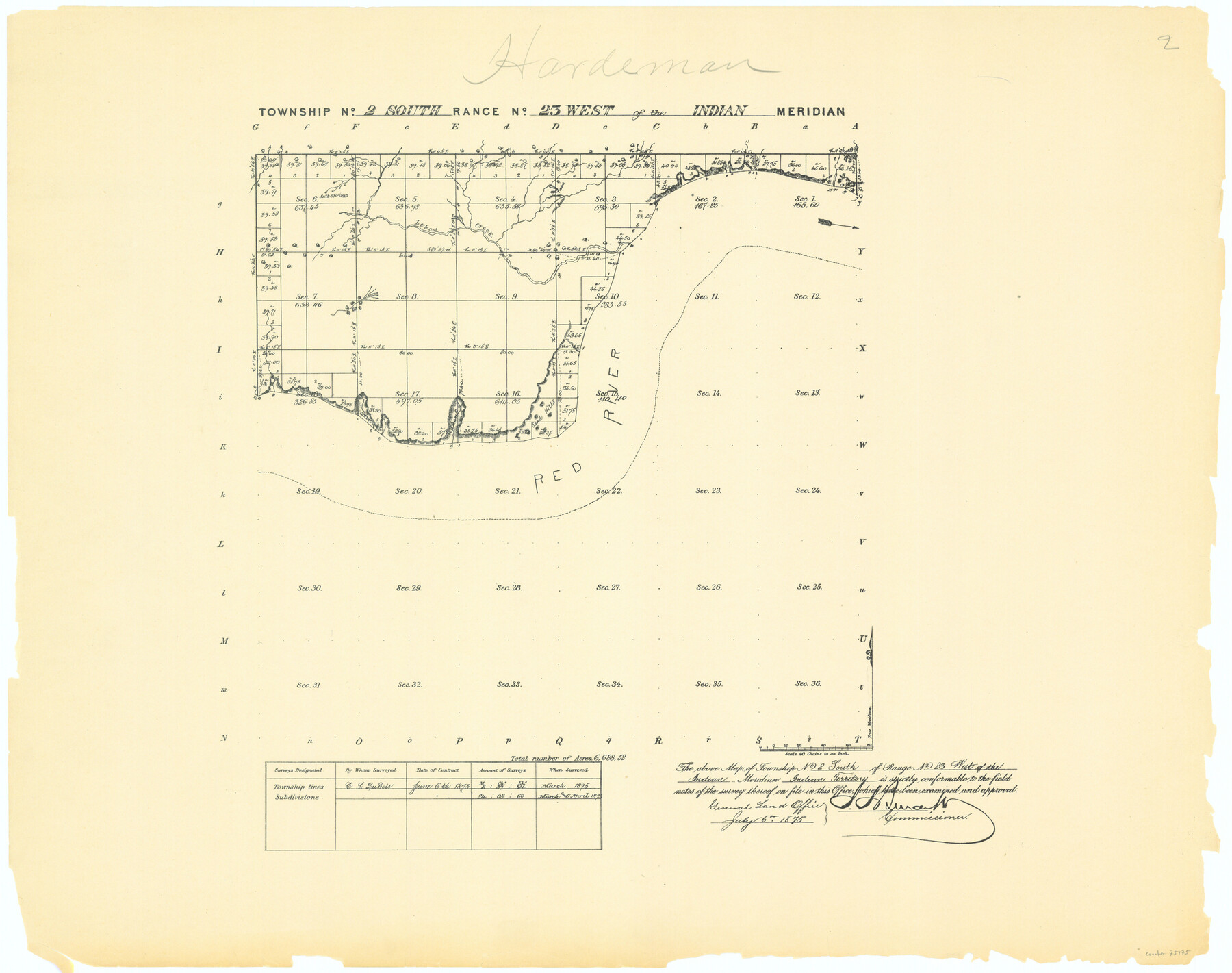
Township No. 2 South Range No. 23 West of the Indian Meridian
-
Map/Doc
75175
-
Collection
General Map Collection
-
Object Dates
1875 (Creation Date)
-
Subjects
Texas Boundaries
-
Height x Width
19.3 x 24.4 inches
49.0 x 62.0 cm
Part of: General Map Collection
Crockett County Working Sketch 38

Print $20.00
- Digital $50.00
Crockett County Working Sketch 38
1928
Size 28.7 x 16.6 inches
Map/Doc 68371
San Patricio County Rolled Sketch 21

Print $20.00
- Digital $50.00
San Patricio County Rolled Sketch 21
1935
Size 25.9 x 24.7 inches
Map/Doc 7580
Cameron County Rolled Sketch 20C

Print $20.00
- Digital $50.00
Cameron County Rolled Sketch 20C
Size 13.1 x 11.9 inches
Map/Doc 5475
La Salle County Rolled Sketch 3

Print $20.00
- Digital $50.00
La Salle County Rolled Sketch 3
1937
Size 32.6 x 38.9 inches
Map/Doc 6568
Johnson County Working Sketch 7

Print $20.00
- Digital $50.00
Johnson County Working Sketch 7
1951
Size 23.0 x 21.3 inches
Map/Doc 66620
Eastland County Working Sketch 5

Print $20.00
- Digital $50.00
Eastland County Working Sketch 5
1918
Size 16.1 x 19.3 inches
Map/Doc 68786
Flight Mission No. CGI-3N, Frame 77, Cameron County

Print $20.00
- Digital $50.00
Flight Mission No. CGI-3N, Frame 77, Cameron County
1954
Size 18.6 x 22.2 inches
Map/Doc 84571
Refugio County Boundary File 2

Print $32.00
- Digital $50.00
Refugio County Boundary File 2
Size 14.1 x 8.8 inches
Map/Doc 58233
Erath County Working Sketch 18

Print $20.00
- Digital $50.00
Erath County Working Sketch 18
1962
Size 30.5 x 34.8 inches
Map/Doc 69099
Flight Mission No. DAG-24K, Frame 48, Matagorda County

Print $20.00
- Digital $50.00
Flight Mission No. DAG-24K, Frame 48, Matagorda County
1953
Size 18.5 x 22.1 inches
Map/Doc 86535
Flight Mission No. DIX-6P, Frame 192, Aransas County

Print $20.00
- Digital $50.00
Flight Mission No. DIX-6P, Frame 192, Aransas County
1956
Size 19.0 x 22.8 inches
Map/Doc 83854
Louisiana and Texas Intracoastal Waterway - Dredging Tributary Channel, Port Aransas to Aransas Pass, Texas

Print $20.00
- Digital $50.00
Louisiana and Texas Intracoastal Waterway - Dredging Tributary Channel, Port Aransas to Aransas Pass, Texas
1940
Size 31.1 x 42.3 inches
Map/Doc 61820
You may also like
Kleberg County Rolled Sketch 11

Print $20.00
- Digital $50.00
Kleberg County Rolled Sketch 11
1915
Size 21.0 x 26.5 inches
Map/Doc 6552
Flight Mission No. DCL-7C, Frame 58, Kenedy County

Print $20.00
- Digital $50.00
Flight Mission No. DCL-7C, Frame 58, Kenedy County
1943
Size 15.3 x 15.1 inches
Map/Doc 86046
Flight Mission No. CGI-2N, Frame 178, Cameron County

Print $20.00
- Digital $50.00
Flight Mission No. CGI-2N, Frame 178, Cameron County
1954
Size 18.5 x 22.1 inches
Map/Doc 84538
Concho County Sketch File 18

Print $32.00
- Digital $50.00
Concho County Sketch File 18
1898
Size 9.1 x 4.4 inches
Map/Doc 19137
Palo Pinto County

Print $20.00
- Digital $50.00
Palo Pinto County
1941
Size 44.9 x 35.9 inches
Map/Doc 77389
Jack County Sketch File 36

Print $120.00
- Digital $50.00
Jack County Sketch File 36
1882
Size 16.3 x 11.0 inches
Map/Doc 27575
Hood County Sketch File 20

Print $4.00
- Digital $50.00
Hood County Sketch File 20
1873
Size 6.8 x 6.9 inches
Map/Doc 26607
Map of the British Isles to illustrate Olney's school geography (Inset: Shetland Isles)

Print $20.00
- Digital $50.00
Map of the British Isles to illustrate Olney's school geography (Inset: Shetland Isles)
1844
Size 12.1 x 9.5 inches
Map/Doc 93547
Ochiltree County Boundary File 2

Print $4.00
- Digital $50.00
Ochiltree County Boundary File 2
Size 7.7 x 8.6 inches
Map/Doc 57675
Map of Bastrop County

Print $20.00
- Digital $50.00
Map of Bastrop County
1861
Size 26.3 x 29.0 inches
Map/Doc 3280
Jefferson County Working Sketch 3

Print $20.00
- Digital $50.00
Jefferson County Working Sketch 3
1904
Size 25.1 x 21.2 inches
Map/Doc 66546
Schleicher County Working Sketch Graphic Index

Print $40.00
- Digital $50.00
Schleicher County Working Sketch Graphic Index
1940
Size 37.8 x 54.2 inches
Map/Doc 76694