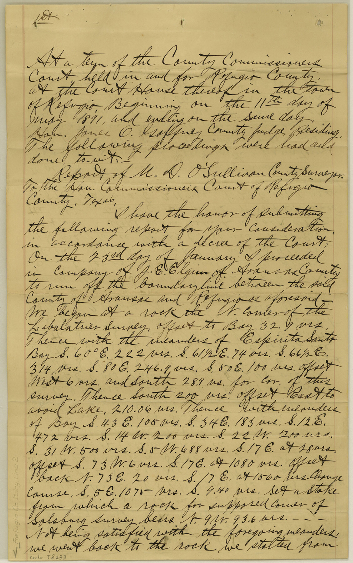
Refugio County Boundary File 2
Line of Aransas and Refugio Counties Established Jan. 1891
-
Map/Doc
58233
-
Collection
General Map Collection
-
Counties
Refugio
-
Subjects
County Boundaries
-
Height x Width
14.1 x 8.8 inches
35.8 x 22.4 cm
Part of: General Map Collection
Val Verde County Working Sketch 91

Print $20.00
- Digital $50.00
Val Verde County Working Sketch 91
1976
Size 46.5 x 42.8 inches
Map/Doc 72226
Colorado County Sketch File 33

Print $44.00
- Digital $50.00
Colorado County Sketch File 33
1847
Size 13.2 x 16.2 inches
Map/Doc 18988
Red River County Sketch File 16

Print $4.00
- Digital $50.00
Red River County Sketch File 16
1866
Size 8.7 x 7.8 inches
Map/Doc 35139
Marion County Rolled Sketch 8

Print $20.00
- Digital $50.00
Marion County Rolled Sketch 8
1998
Size 33.0 x 22.1 inches
Map/Doc 6661
Map of Shelby District

Print $20.00
- Digital $50.00
Map of Shelby District
1847
Size 17.1 x 25.4 inches
Map/Doc 4033
Kaufman County Working Sketch 1

Print $20.00
- Digital $50.00
Kaufman County Working Sketch 1
1921
Size 21.4 x 47.6 inches
Map/Doc 66664
Flight Mission No. DCL-6C, Frame 158, Kenedy County

Print $20.00
- Digital $50.00
Flight Mission No. DCL-6C, Frame 158, Kenedy County
1943
Size 15.3 x 15.2 inches
Map/Doc 85984
Armstrong County Sketch File 7

Print $6.00
- Digital $50.00
Armstrong County Sketch File 7
1902
Size 11.1 x 8.6 inches
Map/Doc 13702
[FT. W. & R. G. Ry. Right of Way Map, Winchell to Brady, McCulloch County, Texas]
![61415, [FT. W. & R. G. Ry. Right of Way Map, Winchell to Brady, McCulloch County, Texas], General Map Collection](https://historictexasmaps.com/wmedia_w700/maps/61415.tif.jpg)
Print $40.00
- Digital $50.00
[FT. W. & R. G. Ry. Right of Way Map, Winchell to Brady, McCulloch County, Texas]
1918
Size 38.2 x 122.0 inches
Map/Doc 61415
Sterling County Rolled Sketch 37

Print $20.00
- Digital $50.00
Sterling County Rolled Sketch 37
Size 13.7 x 16.6 inches
Map/Doc 7862
Taylor County Working Sketch 21

Print $40.00
- Digital $50.00
Taylor County Working Sketch 21
1985
Size 55.9 x 43.8 inches
Map/Doc 69631
Eastland County Working Sketch 25

Print $20.00
- Digital $50.00
Eastland County Working Sketch 25
1922
Size 22.8 x 16.7 inches
Map/Doc 68806
You may also like
Montgomery County Working Sketch 32

Print $20.00
- Digital $50.00
Montgomery County Working Sketch 32
1950
Size 32.8 x 32.8 inches
Map/Doc 71139
Knox County Sketch File 2

Print $40.00
- Digital $50.00
Knox County Sketch File 2
1872
Size 26.5 x 38.0 inches
Map/Doc 76758
Gulf Coast of the United States, Key West to Rio Grande

Print $20.00
- Digital $50.00
Gulf Coast of the United States, Key West to Rio Grande
1892
Size 27.3 x 18.3 inches
Map/Doc 72671
Scurry County Rolled Sketch 3

Print $40.00
- Digital $50.00
Scurry County Rolled Sketch 3
Size 50.2 x 46.7 inches
Map/Doc 9912
Hardeman County Aerial Photograph Index Sheet 5

Print $20.00
- Digital $50.00
Hardeman County Aerial Photograph Index Sheet 5
1950
Size 19.0 x 16.9 inches
Map/Doc 83701
Dimmit County Sketch File 33

Print $4.00
- Digital $50.00
Dimmit County Sketch File 33
1884
Size 8.2 x 8.4 inches
Map/Doc 21151
Travis County

Print $40.00
- Digital $50.00
Travis County
1963
Size 37.7 x 50.7 inches
Map/Doc 73597
Terrell County Working Sketch 29

Print $20.00
- Digital $50.00
Terrell County Working Sketch 29
1944
Size 28.6 x 35.5 inches
Map/Doc 62121
Sunset, Montague Co., Texas

Print $20.00
Sunset, Montague Co., Texas
1890
Size 9.7 x 14.5 inches
Map/Doc 89209
Brazoria County Sketch File 19

Print $36.00
- Digital $50.00
Brazoria County Sketch File 19
1913
Size 8.8 x 5.5 inches
Map/Doc 14998
Real County Rolled Sketch 18

Print $20.00
- Digital $50.00
Real County Rolled Sketch 18
1986
Size 24.9 x 31.9 inches
Map/Doc 7468
General Highway Map, Collingsworth County, Texas

Print $20.00
General Highway Map, Collingsworth County, Texas
1940
Size 18.3 x 25.2 inches
Map/Doc 79053