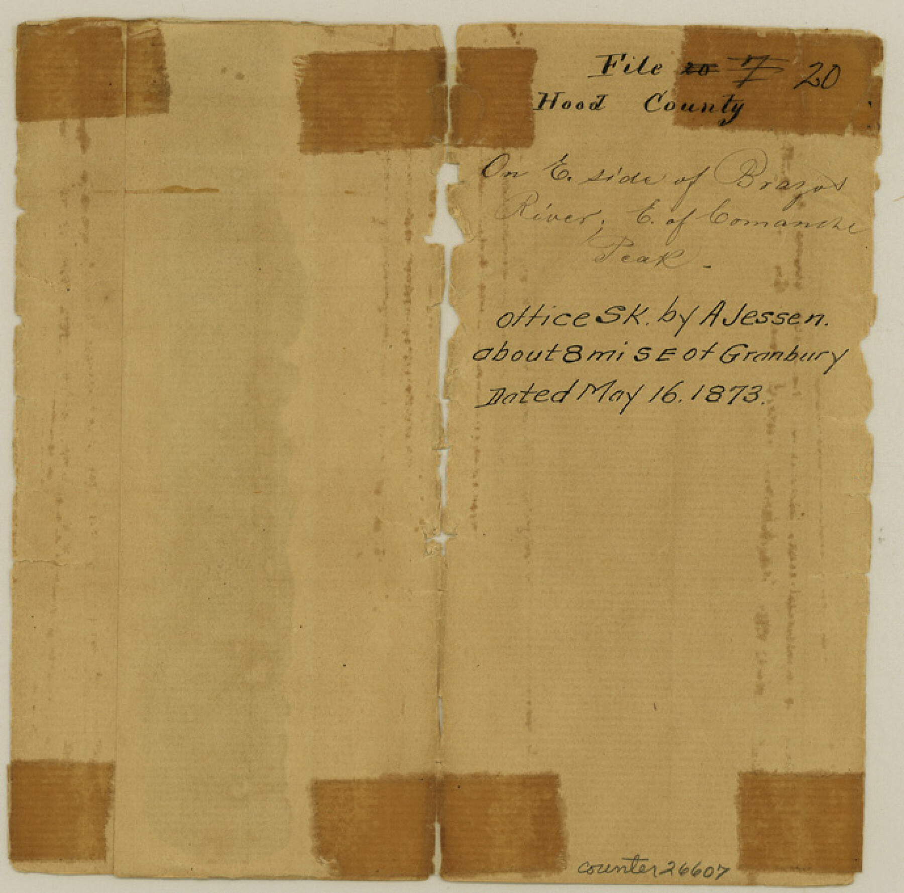
Hood County Sketch File 20
[Office sketch southeast of Granbury]
-
Map/Doc
26607
-
Collection
General Map Collection
-
Object Dates
5/16/1873 (File Date)
5/16/1873 (Creation Date)
-
People and Organizations
A. Jessen (Surveyor/Engineer)
-
Counties
Hood
-
Subjects
Surveying Sketch File
-
Height x Width
6.8 x 6.9 inches
17.3 x 17.5 cm
-
Medium
paper, manuscript
-
Features
Brazos River
Comanche Peak
Part of: General Map Collection
Hemphill County Working Sketch 7

Print $20.00
- Digital $50.00
Hemphill County Working Sketch 7
1964
Size 41.1 x 46.8 inches
Map/Doc 66102
Map of Polk County

Print $20.00
- Digital $50.00
Map of Polk County
1856
Size 22.1 x 23.7 inches
Map/Doc 3961
Nueces County

Print $20.00
- Digital $50.00
Nueces County
1913
Size 25.9 x 34.9 inches
Map/Doc 73252
Borden County Rolled Sketch 10

Print $40.00
- Digital $50.00
Borden County Rolled Sketch 10
1952
Size 110.6 x 29.8 inches
Map/Doc 8449
Galveston County NRC Article 33.136 Sketch 58

Print $26.00
- Digital $50.00
Galveston County NRC Article 33.136 Sketch 58
2009
Size 12.0 x 17.6 inches
Map/Doc 94592
Flight Mission No. DIX-10P, Frame 145, Aransas County

Print $20.00
- Digital $50.00
Flight Mission No. DIX-10P, Frame 145, Aransas County
1956
Size 18.7 x 22.3 inches
Map/Doc 83947
Flight Mission No. DQN-6K, Frame 90, Calhoun County

Print $20.00
- Digital $50.00
Flight Mission No. DQN-6K, Frame 90, Calhoun County
1953
Size 18.6 x 22.2 inches
Map/Doc 84450
Map of Cherokee Co.

Print $40.00
- Digital $50.00
Map of Cherokee Co.
1902
Size 59.7 x 39.6 inches
Map/Doc 4747
Haskell County Boundary File 4b

Print $40.00
- Digital $50.00
Haskell County Boundary File 4b
Size 28.6 x 19.7 inches
Map/Doc 54576
Henderson County Working Sketch 23

Print $20.00
- Digital $50.00
Henderson County Working Sketch 23
1951
Size 28.2 x 24.2 inches
Map/Doc 66156
Milam District

Print $20.00
- Digital $50.00
Milam District
1854
Size 30.2 x 18.9 inches
Map/Doc 3859
Collin County Working Sketch 4

Print $20.00
- Digital $50.00
Collin County Working Sketch 4
1953
Size 20.4 x 21.8 inches
Map/Doc 68098
You may also like
Duval County Sketch File 85

Print $27.00
- Digital $50.00
Duval County Sketch File 85
1935
Size 14.3 x 9.1 inches
Map/Doc 21534
[Surveys in the Liberty District in Tyler and Polk Counties]
![331, [Surveys in the Liberty District in Tyler and Polk Counties], General Map Collection](https://historictexasmaps.com/wmedia_w700/maps/331.tif.jpg)
Print $2.00
- Digital $50.00
[Surveys in the Liberty District in Tyler and Polk Counties]
1847
Size 5.9 x 8.4 inches
Map/Doc 331
Revised Map of Pendleton-Baxter-Addition to Shamrock Located on N.E. 1/4 Section 37, Block 17 H. & G.N.RR.Co., Wheeler County, Texas

Print $20.00
- Digital $50.00
Revised Map of Pendleton-Baxter-Addition to Shamrock Located on N.E. 1/4 Section 37, Block 17 H. & G.N.RR.Co., Wheeler County, Texas
Size 16.7 x 18.8 inches
Map/Doc 92123
Map of Floyd County

Print $20.00
- Digital $50.00
Map of Floyd County
1888
Size 25.4 x 19.6 inches
Map/Doc 3547
Bell County Working Sketch 2

Print $20.00
- Digital $50.00
Bell County Working Sketch 2
1938
Size 25.8 x 28.8 inches
Map/Doc 67342

Stonewall County Boundary File 3a

Print $68.00
- Digital $50.00
Stonewall County Boundary File 3a
Size 14.4 x 9.0 inches
Map/Doc 58970
Ector County Working Sketch 16

Print $40.00
- Digital $50.00
Ector County Working Sketch 16
1956
Size 31.6 x 73.6 inches
Map/Doc 68859
[Map of Connecting Lines along or near the Red River]
![75546, [Map of Connecting Lines along or near the Red River], General Map Collection](https://historictexasmaps.com/wmedia_w700/maps/75546.tif.jpg)
Print $20.00
- Digital $50.00
[Map of Connecting Lines along or near the Red River]
Size 28.6 x 37.0 inches
Map/Doc 75546
Garza County Sketch File C2

Print $6.00
- Digital $50.00
Garza County Sketch File C2
1900
Size 10.3 x 8.4 inches
Map/Doc 24019
Map of the Town of Dawson in John Fullerton, G. W. Rose, David Onstott and Wm. Walker Surveys

Print $20.00
- Digital $50.00
Map of the Town of Dawson in John Fullerton, G. W. Rose, David Onstott and Wm. Walker Surveys
1975
Size 43.1 x 37.1 inches
Map/Doc 93672
Flight Mission No. BRA-7M, Frame117, Jefferson County

Print $20.00
- Digital $50.00
Flight Mission No. BRA-7M, Frame117, Jefferson County
1953
Size 18.7 x 22.4 inches
Map/Doc 85511