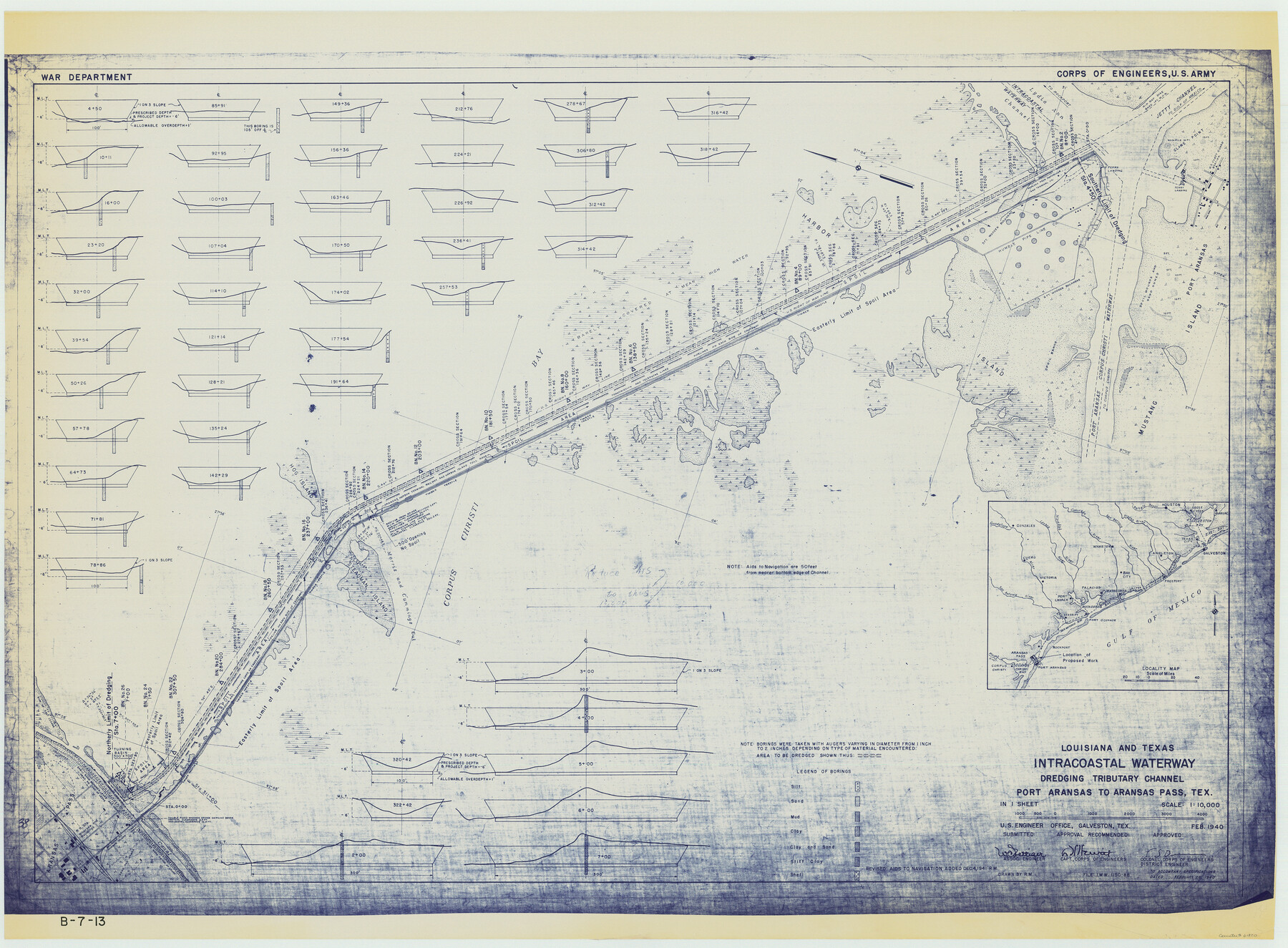
Louisiana and Texas Intracoastal Waterway - Dredging Tributary Channel, Port Aransas to Aransas Pass, Texas
B-7-13
-
Map/Doc
61820
-
Collection
General Map Collection
-
Object Dates
1940 (Creation Date)
-
Subjects
Intracoastal Waterways
-
Height x Width
31.1 x 42.3 inches
79.0 x 107.4 cm
Part of: General Map Collection
From Aransas Pass Eastward, Texas

Print $40.00
- Digital $50.00
From Aransas Pass Eastward, Texas
1866
Size 31.4 x 53.6 inches
Map/Doc 73426
Flight Mission No. CRC-3R, Frame 104, Chambers County

Print $20.00
- Digital $50.00
Flight Mission No. CRC-3R, Frame 104, Chambers County
1956
Size 18.6 x 22.3 inches
Map/Doc 84842
Flight Mission No. DQO-8K, Frame 54, Galveston County

Print $20.00
- Digital $50.00
Flight Mission No. DQO-8K, Frame 54, Galveston County
1952
Size 18.5 x 22.2 inches
Map/Doc 85161
[Jack District Map]
![1991, [Jack District Map], General Map Collection](https://historictexasmaps.com/wmedia_w700/maps/1991.tif.jpg)
Print $20.00
- Digital $50.00
[Jack District Map]
1877
Size 46.4 x 35.8 inches
Map/Doc 1991

Zavala County Working Sketch 30

Print $20.00
- Digital $50.00
Zavala County Working Sketch 30
1989
Size 36.8 x 28.1 inches
Map/Doc 62105
Aransas County NRC Article 33.136 Sketch 20

Print $22.00
- Digital $50.00
Aransas County NRC Article 33.136 Sketch 20
2022
Map/Doc 96876
Flight Mission No. DIX-6P, Frame 189, Aransas County

Print $20.00
- Digital $50.00
Flight Mission No. DIX-6P, Frame 189, Aransas County
1956
Size 19.1 x 22.8 inches
Map/Doc 83851
Flight Mission No. DAH-17M, Frame 20, Orange County

Print $20.00
- Digital $50.00
Flight Mission No. DAH-17M, Frame 20, Orange County
1953
Size 18.6 x 22.6 inches
Map/Doc 86883
Fayette County Working Sketch 3

Print $20.00
- Digital $50.00
Fayette County Working Sketch 3
1980
Size 29.0 x 36.3 inches
Map/Doc 69167
Young County Working Sketch 3

Print $20.00
- Digital $50.00
Young County Working Sketch 3
1919
Size 13.4 x 18.9 inches
Map/Doc 62026
Ector County Working Sketch 31

Print $40.00
- Digital $50.00
Ector County Working Sketch 31
1980
Size 36.0 x 51.0 inches
Map/Doc 68874
You may also like
Castro County Sketch File 4c

Print $4.00
- Digital $50.00
Castro County Sketch File 4c
Size 12.7 x 8.8 inches
Map/Doc 17469
Yellowhouse Land Company's Subdivision of Spade Ranch Lands Situated in Lamb and Hockley Counties, Texas

Print $20.00
- Digital $50.00
Yellowhouse Land Company's Subdivision of Spade Ranch Lands Situated in Lamb and Hockley Counties, Texas
Size 21.5 x 22.5 inches
Map/Doc 92228
Supreme Court of the United States, October Term, 1923, No. 15, Original - The State of Oklahoma, Complainant vs. The State of Texas, Defendant, The United States, Intervener; Report of the Boundary Commissioners

Print $98.00
- Digital $50.00
Supreme Court of the United States, October Term, 1923, No. 15, Original - The State of Oklahoma, Complainant vs. The State of Texas, Defendant, The United States, Intervener; Report of the Boundary Commissioners
1924
Size 6.1 x 9.2 inches
Map/Doc 3058
Live Oak County Working Sketch 37

Print $40.00
- Digital $50.00
Live Oak County Working Sketch 37
2012
Size 34.4 x 48.7 inches
Map/Doc 93363
Live Oak County Working Sketch 7

Print $20.00
- Digital $50.00
Live Oak County Working Sketch 7
1937
Size 24.9 x 37.6 inches
Map/Doc 70592

Panola County Working Sketch 18

Print $20.00
- Digital $50.00
Panola County Working Sketch 18
1945
Map/Doc 71427
Colorado County Sketch File 31

Print $4.00
- Digital $50.00
Colorado County Sketch File 31
1838
Size 12.8 x 7.8 inches
Map/Doc 18984
Flight Mission No. CRC-3R, Frame 43, Chambers County

Print $20.00
- Digital $50.00
Flight Mission No. CRC-3R, Frame 43, Chambers County
1956
Size 18.5 x 22.3 inches
Map/Doc 84816
Webb County Rolled Sketch 67

Print $20.00
- Digital $50.00
Webb County Rolled Sketch 67
1927
Size 31.4 x 32.0 inches
Map/Doc 10130
Lampasas County Working Sketch 14

Print $20.00
- Digital $50.00
Lampasas County Working Sketch 14
1974
Size 23.4 x 21.8 inches
Map/Doc 70291
[Blueprint of unknown Block/Surveys]
![92139, [Blueprint of unknown Block/Surveys], Twichell Survey Records](https://historictexasmaps.com/wmedia_w700/maps/92139-1.tif.jpg)
Print $20.00
- Digital $50.00
[Blueprint of unknown Block/Surveys]
Size 24.7 x 26.8 inches
Map/Doc 92139