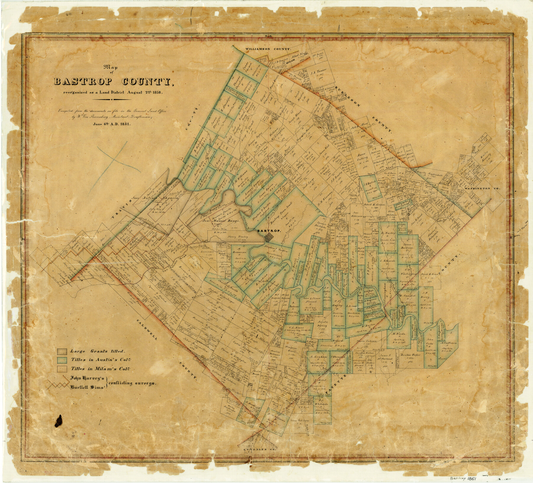
Map of Bastrop County
-
Map/Doc
3280
-
Collection
General Map Collection
-
Object Dates
1861/6/6 (Creation Date)
-
People and Organizations
Texas General Land Office (Publisher)
John Harvey (Surveyor/Engineer)
Bartlett Sims (Surveyor/Engineer)
W. von Rosenberg (Draftsman)
-
Counties
Bastrop
-
Subjects
County
-
Height x Width
26.3 x 29.0 inches
66.8 x 73.7 cm
-
Comments
Reorganized as a Land District August 2, 1858.
-
Features
Walnut Creek
Cedar Fork of Sandy Creek
Mahards Creek
Peach Creek
Buckner's Creek
East Prong of Pin Oak Creek
West Prong of Pin Oak Creek
Pin Oak Creek
Ten Mile Creek
Bastrop
Yegua Creek
Alum Creek
Copperas Creek
San Antonio Road
Piney Creek
Colorado River
Cedar Creek
Wilbarger's [sic] Creek
Sandy Creek
Part of: General Map Collection
Montgomery County Rolled Sketch 41

Print $20.00
- Digital $50.00
Montgomery County Rolled Sketch 41
1975
Size 35.2 x 26.8 inches
Map/Doc 6814
Wharton County Working Sketch 21

Print $20.00
- Digital $50.00
Wharton County Working Sketch 21
1937
Size 16.9 x 20.8 inches
Map/Doc 72485
Falls County Sketch File 28

Print $2.00
- Digital $50.00
Falls County Sketch File 28
Size 7.7 x 10.3 inches
Map/Doc 22438
Geological Map of the United States, Canada & c. compiled from the state surveys of the U.S. and other sources

Print $20.00
- Digital $50.00
Geological Map of the United States, Canada & c. compiled from the state surveys of the U.S. and other sources
1845
Size 16.6 x 21.6 inches
Map/Doc 95173

Jeff Davis County Working Sketch 22

Print $20.00
- Digital $50.00
Jeff Davis County Working Sketch 22
1957
Size 18.9 x 20.9 inches
Map/Doc 66517
Fannin County Working Sketch 8

Print $20.00
- Digital $50.00
Fannin County Working Sketch 8
1955
Size 27.2 x 16.0 inches
Map/Doc 69162
Montgomery County Sketch File 30

Print $20.00
- Digital $50.00
Montgomery County Sketch File 30
Size 37.5 x 41.7 inches
Map/Doc 10549
[Surveys along the boundary between Jasper and Jefferson Counties]
![99, [Surveys along the boundary between Jasper and Jefferson Counties], General Map Collection](https://historictexasmaps.com/wmedia_w700/maps/99.tif.jpg)
Print $3.00
- Digital $50.00
[Surveys along the boundary between Jasper and Jefferson Counties]
1841
Size 9.3 x 16.9 inches
Map/Doc 99
Eastland County Working Sketch 51

Print $20.00
- Digital $50.00
Eastland County Working Sketch 51
1982
Size 37.7 x 39.6 inches
Map/Doc 68832
Wise County Sketch File 20

Print $14.00
- Digital $50.00
Wise County Sketch File 20
1860
Size 12.8 x 7.9 inches
Map/Doc 40557
Flight Mission No. DQO-2K, Frame 147, Galveston County

Print $20.00
- Digital $50.00
Flight Mission No. DQO-2K, Frame 147, Galveston County
1952
Size 18.8 x 22.6 inches
Map/Doc 85044
You may also like
Swisher County

Print $20.00
- Digital $50.00
Swisher County
1910
Size 45.3 x 39.1 inches
Map/Doc 63054
Brewster County Rolled Sketch 19A

Print $20.00
- Digital $50.00
Brewster County Rolled Sketch 19A
1881
Size 31.5 x 38.6 inches
Map/Doc 8471
Harris County Working Sketch 37

Print $20.00
- Digital $50.00
Harris County Working Sketch 37
1938
Size 25.4 x 28.0 inches
Map/Doc 65929
Hansford County Sketch File 1

Print $7.00
- Digital $50.00
Hansford County Sketch File 1
1888
Size 39.0 x 31.3 inches
Map/Doc 10475
Brewster County Rolled Sketch 60

Print $40.00
- Digital $50.00
Brewster County Rolled Sketch 60
1942
Size 42.9 x 48.0 inches
Map/Doc 16960
McCulloch County Working Sketch 18

Print $20.00
- Digital $50.00
McCulloch County Working Sketch 18
1997
Size 42.9 x 32.8 inches
Map/Doc 70693
Jeff Davis County Working Sketch 25

Print $20.00
- Digital $50.00
Jeff Davis County Working Sketch 25
1959
Size 28.9 x 32.2 inches
Map/Doc 66520
Flight Mission No. BRA-8M, Frame 87, Jefferson County

Print $20.00
- Digital $50.00
Flight Mission No. BRA-8M, Frame 87, Jefferson County
1953
Size 18.6 x 22.3 inches
Map/Doc 85607
Liberty County Rolled Sketch JP2

Print $40.00
- Digital $50.00
Liberty County Rolled Sketch JP2
1935
Size 52.2 x 12.7 inches
Map/Doc 81403
[Sketch for Mineral Application 24072, San Jacinto River]
![65591, [Sketch for Mineral Application 24072, San Jacinto River], General Map Collection](https://historictexasmaps.com/wmedia_w700/maps/65591.tif.jpg)
Print $20.00
- Digital $50.00
[Sketch for Mineral Application 24072, San Jacinto River]
1929
Size 21.0 x 39.8 inches
Map/Doc 65591
Flight Mission No. DIX-3P, Frame 134, Aransas County

Print $20.00
- Digital $50.00
Flight Mission No. DIX-3P, Frame 134, Aransas County
1956
Size 17.8 x 19.0 inches
Map/Doc 83764
Orange County Working Sketch 39

Print $20.00
- Digital $50.00
Orange County Working Sketch 39
1966
Size 20.5 x 27.8 inches
Map/Doc 71371