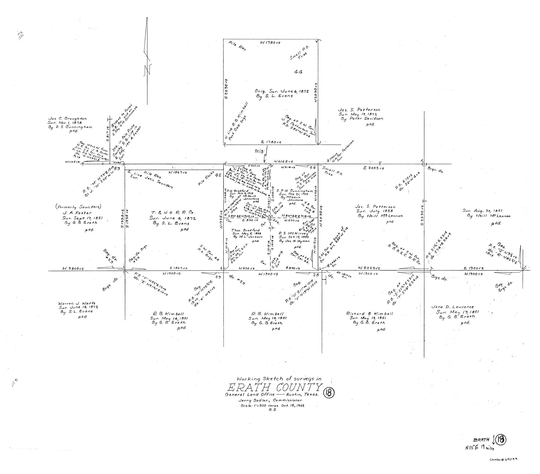
Erath County Working Sketch 18
-
Map/Doc
69099
-
Collection
General Map Collection
-
Object Dates
10/15/1962 (Creation Date)
-
People and Organizations
Roy Buckholts (Draftsman)
-
Counties
Erath
-
Subjects
Surveying Working Sketch
-
Height x Width
30.5 x 34.8 inches
77.5 x 88.4 cm
-
Scale
1" = 300 varas
Part of: General Map Collection
Brewster County Rolled Sketch 66

Print $20.00
- Digital $50.00
Brewster County Rolled Sketch 66
1940
Size 33.0 x 36.2 inches
Map/Doc 8490
Victoria County Rolled Sketch 7

Print $40.00
- Digital $50.00
Victoria County Rolled Sketch 7
1945
Size 54.2 x 16.3 inches
Map/Doc 10098
Hardeman County Rolled Sketch 19

Print $52.00
- Digital $50.00
Hardeman County Rolled Sketch 19
1927
Size 30.9 x 31.5 inches
Map/Doc 9109
Flight Mission No. DAG-17K, Frame 120, Matagorda County

Print $20.00
- Digital $50.00
Flight Mission No. DAG-17K, Frame 120, Matagorda County
1952
Size 18.6 x 22.4 inches
Map/Doc 86340
Polk County Sketch File 32

Print $8.00
- Digital $50.00
Polk County Sketch File 32
1887
Size 12.8 x 8.0 inches
Map/Doc 34226
Parker County

Print $20.00
- Digital $50.00
Parker County
1942
Size 45.7 x 37.8 inches
Map/Doc 66972
Map of Randall County

Print $20.00
- Digital $50.00
Map of Randall County
1893
Size 26.5 x 20.0 inches
Map/Doc 73338
Webb County Rolled Sketch 59

Print $20.00
- Digital $50.00
Webb County Rolled Sketch 59
1947
Size 15.3 x 26.7 inches
Map/Doc 8210
Montague County Sketch File 6

Print $4.00
- Digital $50.00
Montague County Sketch File 6
1856
Size 8.0 x 8.4 inches
Map/Doc 31717
[Surveys along Richland Creek]
![320, [Surveys along Richland Creek], General Map Collection](https://historictexasmaps.com/wmedia_w700/maps/320.tif.jpg)
Print $2.00
- Digital $50.00
[Surveys along Richland Creek]
Size 7.2 x 6.0 inches
Map/Doc 320
Right of Way & Track Map, St. Louis, Brownsville & Mexico Ry. operated by St. Louis, Brownsville & Mexico Ry. Co.

Print $40.00
- Digital $50.00
Right of Way & Track Map, St. Louis, Brownsville & Mexico Ry. operated by St. Louis, Brownsville & Mexico Ry. Co.
1919
Size 25.8 x 56.9 inches
Map/Doc 64620
Flight Mission No. DAG-17K, Frame 72, Matagorda County

Print $20.00
- Digital $50.00
Flight Mission No. DAG-17K, Frame 72, Matagorda County
1952
Size 18.6 x 22.4 inches
Map/Doc 86331
You may also like
Nueces County NRC Article 33.136 Sketch 2

Print $20.00
- Digital $50.00
Nueces County NRC Article 33.136 Sketch 2
2002
Size 29.3 x 44.4 inches
Map/Doc 61622
Cameron County

Print $20.00
- Digital $50.00
Cameron County
1913
Size 28.9 x 32.1 inches
Map/Doc 4752
Matagorda County State Real Property Sketch 1

Print $20.00
- Digital $50.00
Matagorda County State Real Property Sketch 1
1989
Size 19.1 x 25.2 inches
Map/Doc 95171
Jack County Rolled Sketch 2

Print $20.00
- Digital $50.00
Jack County Rolled Sketch 2
1972
Size 31.3 x 29.0 inches
Map/Doc 6332
Val Verde County Working Sketch 113

Print $40.00
- Digital $50.00
Val Verde County Working Sketch 113
2003
Size 54.9 x 34.6 inches
Map/Doc 78492
Nueces County Sketch File 39

Print $8.00
- Digital $50.00
Nueces County Sketch File 39
1934
Size 11.0 x 8.5 inches
Map/Doc 32623
St. L. S-W. Ry. of Texas Map of Lufkin Branch in Cherokee County Texas

Print $20.00
- Digital $50.00
St. L. S-W. Ry. of Texas Map of Lufkin Branch in Cherokee County Texas
1912
Size 22.0 x 17.8 inches
Map/Doc 64790
Reagan County Working Sketch 21

Print $20.00
- Digital $50.00
Reagan County Working Sketch 21
1955
Size 23.4 x 19.9 inches
Map/Doc 71863
Smithville, Bastrop County, Texas

Print $3.00
- Digital $50.00
Smithville, Bastrop County, Texas
1895
Size 11.0 x 17.2 inches
Map/Doc 531
King County Working Sketch 8

Print $20.00
- Digital $50.00
King County Working Sketch 8
1955
Size 30.8 x 24.8 inches
Map/Doc 70172
[Blocks T1, T2, T3, S3, A, O5, and Capitol Leagues in Northwest Lamb County and Southwest Castro County]
![91005, [Blocks T1, T2, T3, S3, A, O5, and Capitol Leagues in Northwest Lamb County and Southwest Castro County], Twichell Survey Records](https://historictexasmaps.com/wmedia_w700/maps/91005-1.tif.jpg)
Print $20.00
- Digital $50.00
[Blocks T1, T2, T3, S3, A, O5, and Capitol Leagues in Northwest Lamb County and Southwest Castro County]
Size 30.3 x 34.0 inches
Map/Doc 91005
Wilbarger Co.

Print $40.00
- Digital $50.00
Wilbarger Co.
1889
Size 48.2 x 39.0 inches
Map/Doc 63124