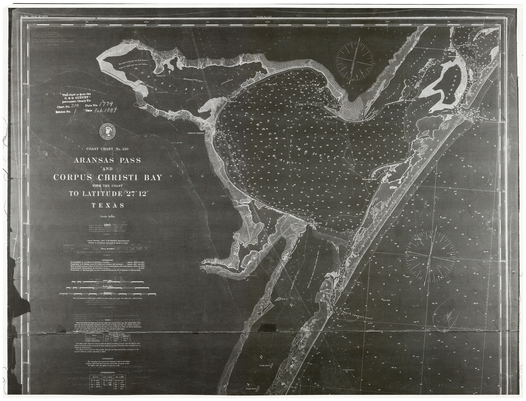
Coast Chart No. 210 - Aransas Pass and Corpus Christi Bay with the coast to latitude 27° 12', Texas
K-2-210a1
-
Map/Doc
73446
-
Collection
General Map Collection
-
Object Dates
1887 (Creation Date)
-
Counties
Aransas San Patricio Nueces Kleberg
-
Subjects
Nautical Charts
-
Height x Width
18.1 x 23.8 inches
46.0 x 60.5 cm
Part of: General Map Collection
Marion County Rolled Sketch 5

Print $20.00
- Digital $50.00
Marion County Rolled Sketch 5
1961
Size 22.6 x 20.5 inches
Map/Doc 6658

Hockley County Sketch File 8

Print $20.00
- Digital $50.00
Hockley County Sketch File 8
Size 35.0 x 26.2 inches
Map/Doc 11771
Right of Way & Track Map, St. Louis, Brownsville & Mexico Ry. operated by St. Louis, Brownsville & Mexico Ry. Co.

Print $40.00
- Digital $50.00
Right of Way & Track Map, St. Louis, Brownsville & Mexico Ry. operated by St. Louis, Brownsville & Mexico Ry. Co.
1919
Size 25.8 x 56.9 inches
Map/Doc 64620
Bosque County Working Sketch 26

Print $20.00
- Digital $50.00
Bosque County Working Sketch 26
1995
Size 46.0 x 35.5 inches
Map/Doc 67460
Flight Mission No. BRA-16M, Frame 73, Jefferson County

Print $20.00
- Digital $50.00
Flight Mission No. BRA-16M, Frame 73, Jefferson County
1953
Size 18.7 x 22.3 inches
Map/Doc 85690
Gregg County Sketch File 5

Print $6.00
- Digital $50.00
Gregg County Sketch File 5
1931
Size 11.2 x 8.7 inches
Map/Doc 24574
El Paso County Rolled Sketch 16

Print $40.00
- Digital $50.00
El Paso County Rolled Sketch 16
1885
Size 21.5 x 52.0 inches
Map/Doc 8855
Burnet County Working Sketch 9

Print $20.00
- Digital $50.00
Burnet County Working Sketch 9
1975
Size 39.7 x 25.2 inches
Map/Doc 67852
Walker County Sketch File 2

Print $6.00
- Digital $50.00
Walker County Sketch File 2
1854
Size 10.5 x 15.9 inches
Map/Doc 39549
Burnet County Sketch File 1

Print $40.00
- Digital $50.00
Burnet County Sketch File 1
1847
Size 16.1 x 12.4 inches
Map/Doc 16670
Houston including Bellaire, Bunker Hill, Galena Park, Hedwig, Hilshire, Hunters Creek, Jacinto City, Jersey Village, Missouri City, Pasadena, Piney Point, South Houston, Spring Valley, West University Place and adjoining communities [Recto]
![94179, Houston including Bellaire, Bunker Hill, Galena Park, Hedwig, Hilshire, Hunters Creek, Jacinto City, Jersey Village, Missouri City, Pasadena, Piney Point, South Houston, Spring Valley, West University Place and adjoining communities [Recto], General Map Collection](https://historictexasmaps.com/wmedia_w700/maps/94179.tif.jpg)
Houston including Bellaire, Bunker Hill, Galena Park, Hedwig, Hilshire, Hunters Creek, Jacinto City, Jersey Village, Missouri City, Pasadena, Piney Point, South Houston, Spring Valley, West University Place and adjoining communities [Recto]
Size 27.1 x 42.6 inches
Map/Doc 94179
You may also like
Stonewall County Rolled Sketch 24B

Print $40.00
- Digital $50.00
Stonewall County Rolled Sketch 24B
1954
Size 50.1 x 43.1 inches
Map/Doc 9964
New Map of the State of Texas compiled from J. De Cordova's large map

Print $20.00
- Digital $50.00
New Map of the State of Texas compiled from J. De Cordova's large map
1855
Map/Doc 93943
Atascosa County Sketch File 20

Print $4.00
- Digital $50.00
Atascosa County Sketch File 20
Size 7.9 x 9.0 inches
Map/Doc 13787
Comal County Working Sketch 2

Print $20.00
- Digital $50.00
Comal County Working Sketch 2
1940
Size 19.8 x 20.9 inches
Map/Doc 68168
Montgomery County Working Sketch 4

Print $20.00
- Digital $50.00
Montgomery County Working Sketch 4
1926
Size 20.9 x 22.2 inches
Map/Doc 71110
Clay County Rolled Sketch 1

Print $20.00
- Digital $50.00
Clay County Rolled Sketch 1
1940
Size 47.0 x 37.9 inches
Map/Doc 8621
Eastland County Working Sketch 12

Print $20.00
- Digital $50.00
Eastland County Working Sketch 12
1919
Size 23.8 x 21.1 inches
Map/Doc 68793
Webb County Rolled Sketch 56

Print $20.00
- Digital $50.00
Webb County Rolled Sketch 56
1945
Size 22.2 x 23.7 inches
Map/Doc 8208
Hudspeth County Working Sketch 40

Print $20.00
- Digital $50.00
Hudspeth County Working Sketch 40
1981
Size 35.6 x 43.8 inches
Map/Doc 66325
John B. Slaughter Ranch Situated in Garza County, Texas

Print $20.00
- Digital $50.00
John B. Slaughter Ranch Situated in Garza County, Texas
Size 32.5 x 44.7 inches
Map/Doc 92657
Wichita County Rolled Sketch 17

Print $117.00
- Digital $50.00
Wichita County Rolled Sketch 17
Size 10.4 x 15.4 inches
Map/Doc 49488
Hall County Sketch File 2

Print $12.00
- Digital $50.00
Hall County Sketch File 2
1880
Size 17.1 x 8.4 inches
Map/Doc 42261