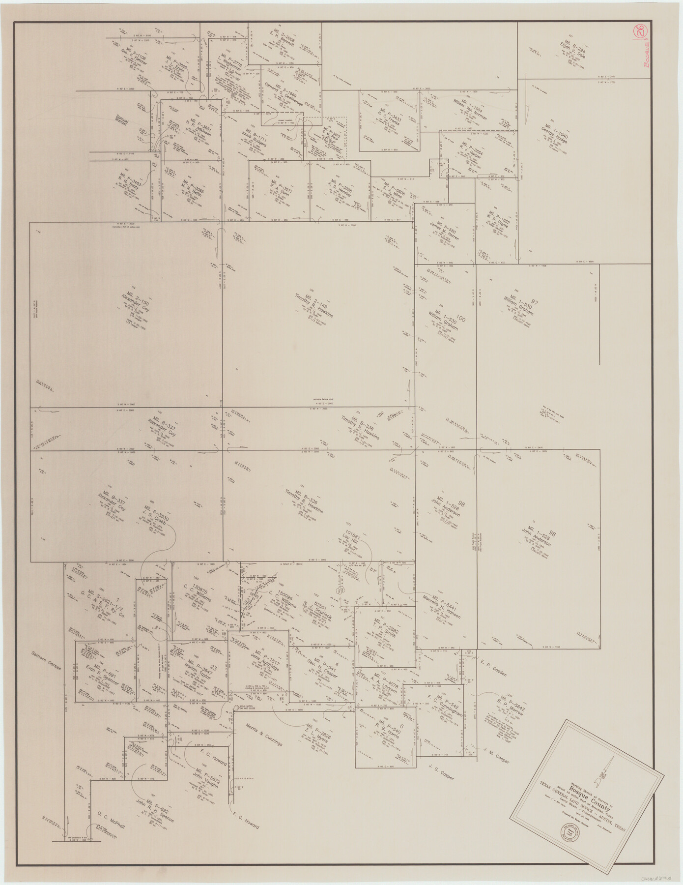
Bosque County Working Sketch 26
-
Map/Doc
67460
-
Collection
General Map Collection
-
Object Dates
4/19/1995 (Creation Date)
-
People and Organizations
Joan Kilpatrick (Draftsman)
Garry Mauro (GLO Commissioner)
-
Counties
Bosque
-
Subjects
Surveying Working Sketch
-
Height x Width
46.0 x 35.5 inches
116.8 x 90.2 cm
-
Scale
1" = 300 varas
-
Comments
Surveys located about 10 miles West of Meridian, Texas.
Part of: General Map Collection
El Paso County Working Sketch 21

Print $20.00
- Digital $50.00
El Paso County Working Sketch 21
1960
Size 37.8 x 30.9 inches
Map/Doc 69043
Aransas County NRC Article 33.136 Sketch 5

Print $20.00
- Digital $50.00
Aransas County NRC Article 33.136 Sketch 5
2005
Size 18.5 x 24.7 inches
Map/Doc 83521
[Surveys in the Bexar District along the Guadalupe River]
![124, [Surveys in the Bexar District along the Guadalupe River], General Map Collection](https://historictexasmaps.com/wmedia_w700/maps/124.tif.jpg)
Print $3.00
- Digital $50.00
[Surveys in the Bexar District along the Guadalupe River]
1841
Size 17.2 x 10.8 inches
Map/Doc 124
Knox County Sketch File 8

Print $26.00
- Digital $50.00
Knox County Sketch File 8
1882
Size 8.6 x 7.8 inches
Map/Doc 29218
Kenedy County Aerial Photograph Index Sheet 6

Print $20.00
- Digital $50.00
Kenedy County Aerial Photograph Index Sheet 6
1943
Size 23.4 x 18.4 inches
Map/Doc 83716
Kleberg County Rolled Sketch 10-35

Print $20.00
- Digital $50.00
Kleberg County Rolled Sketch 10-35
1952
Size 38.2 x 35.4 inches
Map/Doc 9366
Bell County Sketch File 29

Print $4.00
- Digital $50.00
Bell County Sketch File 29
1874
Size 13.1 x 8.1 inches
Map/Doc 14439
Duval County Working Sketch 32

Print $20.00
- Digital $50.00
Duval County Working Sketch 32
1950
Size 18.8 x 18.0 inches
Map/Doc 68756
Briscoe County Sketch File 4

Print $40.00
- Digital $50.00
Briscoe County Sketch File 4
Size 26.0 x 33.5 inches
Map/Doc 10993
Jefferson County Sketch File 21a

Print $44.00
- Digital $50.00
Jefferson County Sketch File 21a
Size 12.4 x 15.1 inches
Map/Doc 28175
Bailey County Sketch File 1

Print $40.00
- Digital $50.00
Bailey County Sketch File 1
1882
Size 15.8 x 15.3 inches
Map/Doc 10880
Township 10 North Range 14 West, North Western District, Louisiana

Print $20.00
- Digital $50.00
Township 10 North Range 14 West, North Western District, Louisiana
1854
Size 19.5 x 24.5 inches
Map/Doc 65872
You may also like
Waller County

Print $20.00
- Digital $50.00
Waller County
1945
Size 46.4 x 27.1 inches
Map/Doc 77449
Sketch from the map of Bailey Co.

Print $2.00
- Digital $50.00
Sketch from the map of Bailey Co.
Size 8.4 x 7.6 inches
Map/Doc 464

Sutton County Working Sketch 23

Print $20.00
- Digital $50.00
Sutton County Working Sketch 23
1981
Size 17.3 x 27.1 inches
Map/Doc 62366
Perspective Map of the City of Laredo

Print $20.00
- Digital $50.00
Perspective Map of the City of Laredo
1892
Size 24.2 x 36.3 inches
Map/Doc 97096
Ellis County Sketch File 10

Print $40.00
- Digital $50.00
Ellis County Sketch File 10
1860
Size 12.7 x 16.1 inches
Map/Doc 21845
Crosby County Sketch File 20

Print $20.00
- Digital $50.00
Crosby County Sketch File 20
Size 25.9 x 18.3 inches
Map/Doc 11252
Kinney County Rolled Sketch 6

Print $20.00
- Digital $50.00
Kinney County Rolled Sketch 6
Size 27.1 x 36.8 inches
Map/Doc 6536
Galveston County Boundary File 32

Print $52.00
- Digital $50.00
Galveston County Boundary File 32
Size 16.7 x 13.6 inches
Map/Doc 53658
Eastland County Working Sketch 33

Print $20.00
- Digital $50.00
Eastland County Working Sketch 33
1956
Size 23.0 x 12.4 inches
Map/Doc 68814
Galveston County Working Sketch 12

Print $20.00
- Digital $50.00
Galveston County Working Sketch 12
1967
Size 14.8 x 22.4 inches
Map/Doc 69349
Nueces County Rolled Sketch 70

Print $60.00
Nueces County Rolled Sketch 70
1980
Size 25.3 x 38.0 inches
Map/Doc 6921