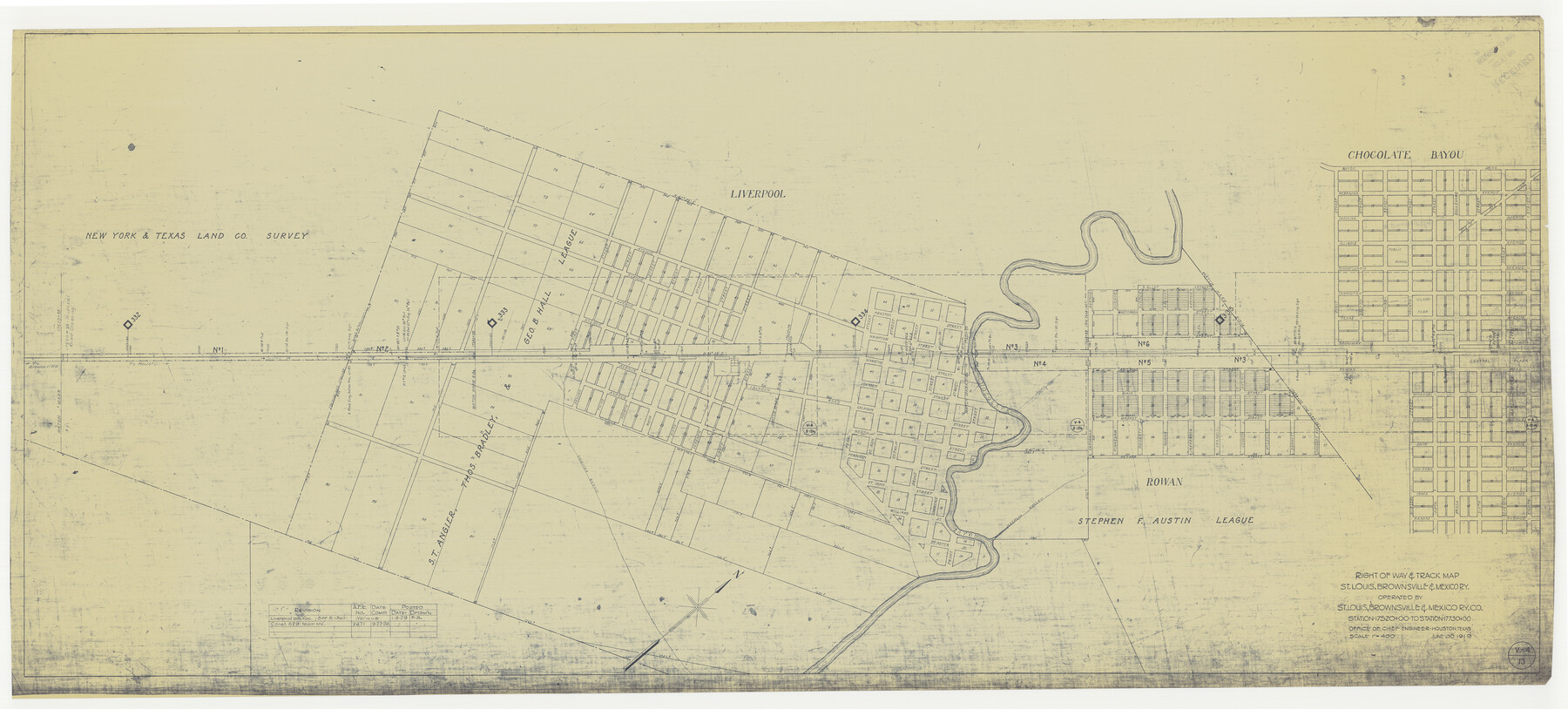
Right of Way & Track Map, St. Louis, Brownsville & Mexico Ry. operated by St. Louis, Brownsville & Mexico Ry. Co.
Station 17520+00 to Station 17730+00
Z-2-183
-
Map/Doc
64620
-
Collection
General Map Collection
-
Object Dates
1919/6/30 (Creation Date)
-
Counties
Brazoria
-
Subjects
Railroads
-
Height x Width
25.8 x 56.9 inches
65.5 x 144.5 cm
-
Medium
blueprint/diazo
-
Scale
1" = 400 feet
-
Comments
Jefferson Lake Oil Company.
See counter nos. 64612 through 64619 and 64621 through 64626 for other sheets. -
Features
SLB&M
Chocolate Bayou
Rowan
Mechlin Gulley
Liverpool
Conner Bayou
[Railroad line] to Houston
[Railroad line] to Brownsville
Part of: General Map Collection
Houston County Sketch File 36

Print $40.00
- Digital $50.00
Houston County Sketch File 36
1945
Size 15.6 x 14.2 inches
Map/Doc 26817
San Augustine County Working Sketch 13

Print $20.00
- Digital $50.00
San Augustine County Working Sketch 13
1952
Size 34.0 x 27.6 inches
Map/Doc 63701
Gonzales County

Print $40.00
- Digital $50.00
Gonzales County
1920
Size 41.0 x 51.2 inches
Map/Doc 1841
Pecos County Working Sketch 19

Print $20.00
- Digital $50.00
Pecos County Working Sketch 19
1917
Size 21.0 x 14.6 inches
Map/Doc 71489
Stonewall County Working Sketch 28

Print $20.00
- Digital $50.00
Stonewall County Working Sketch 28
1976
Size 34.5 x 39.2 inches
Map/Doc 62335
[Galveston, Harrisburg & San Antonio Railroad from Cuero to Stockdale]
![64186, [Galveston, Harrisburg & San Antonio Railroad from Cuero to Stockdale], General Map Collection](https://historictexasmaps.com/wmedia_w700/maps/64186.tif.jpg)
Print $20.00
- Digital $50.00
[Galveston, Harrisburg & San Antonio Railroad from Cuero to Stockdale]
1906
Size 13.4 x 33.1 inches
Map/Doc 64186
Capitol Land Reservation

Print $20.00
- Digital $50.00
Capitol Land Reservation
1880
Size 43.7 x 34.2 inches
Map/Doc 10745
Bexar County Working Sketch 15

Print $20.00
- Digital $50.00
Bexar County Working Sketch 15
1972
Size 38.3 x 43.3 inches
Map/Doc 67331
McLennan County Sketch File 17

Print $4.00
- Digital $50.00
McLennan County Sketch File 17
1876
Size 7.9 x 12.7 inches
Map/Doc 31278
Knox County Boundary File 2

Print $40.00
- Digital $50.00
Knox County Boundary File 2
Size 31.1 x 34.1 inches
Map/Doc 65017
San Antonio & Aransas Pass

Print $40.00
- Digital $50.00
San Antonio & Aransas Pass
Size 30.9 x 74.5 inches
Map/Doc 64633
Wilbarger County Sketch File 13

Print $28.00
- Digital $50.00
Wilbarger County Sketch File 13
1885
Size 12.7 x 8.0 inches
Map/Doc 40189
You may also like
Township No. 4 South Range No. 16 West of the Indian Meridian

Print $20.00
- Digital $50.00
Township No. 4 South Range No. 16 West of the Indian Meridian
1875
Size 19.4 x 24.4 inches
Map/Doc 75165
Real County Working Sketch 6

Print $20.00
- Digital $50.00
Real County Working Sketch 6
1924
Size 21.2 x 9.3 inches
Map/Doc 71898
Bee County Working Sketch 26

Print $20.00
- Digital $50.00
Bee County Working Sketch 26
1987
Size 30.9 x 36.0 inches
Map/Doc 67276
Eastland County

Print $20.00
- Digital $50.00
Eastland County
1945
Size 41.8 x 42.0 inches
Map/Doc 77268
Plan de la Villa de Austin

Print $20.00
- Digital $50.00
Plan de la Villa de Austin
1828
Size 18.5 x 12.5 inches
Map/Doc 94116
Honey Grove, Tex., Fannin County, 1886

Print $20.00
Honey Grove, Tex., Fannin County, 1886
1886
Size 18.4 x 23.9 inches
Map/Doc 93479
San Jacinto County

Print $40.00
- Digital $50.00
San Jacinto County
1942
Size 49.7 x 44.1 inches
Map/Doc 95633
Starr County Sketch File 25

Print $42.00
- Digital $50.00
Starr County Sketch File 25
1921
Size 9.1 x 8.6 inches
Map/Doc 36927
Burnet County Sketch File 30

Print $4.00
- Digital $50.00
Burnet County Sketch File 30
Size 11.0 x 8.0 inches
Map/Doc 16746
Loving County Working Sketch 7

Print $20.00
- Digital $50.00
Loving County Working Sketch 7
1949
Size 23.4 x 26.3 inches
Map/Doc 70639
College Park Addition to the City of Lubbock Located on Section 9, Block B

Print $20.00
- Digital $50.00
College Park Addition to the City of Lubbock Located on Section 9, Block B
Size 12.9 x 15.9 inches
Map/Doc 92277
Flight Mission No. CLL-1N, Frame 37, Willacy County

Print $20.00
- Digital $50.00
Flight Mission No. CLL-1N, Frame 37, Willacy County
1954
Size 18.4 x 22.0 inches
Map/Doc 87018