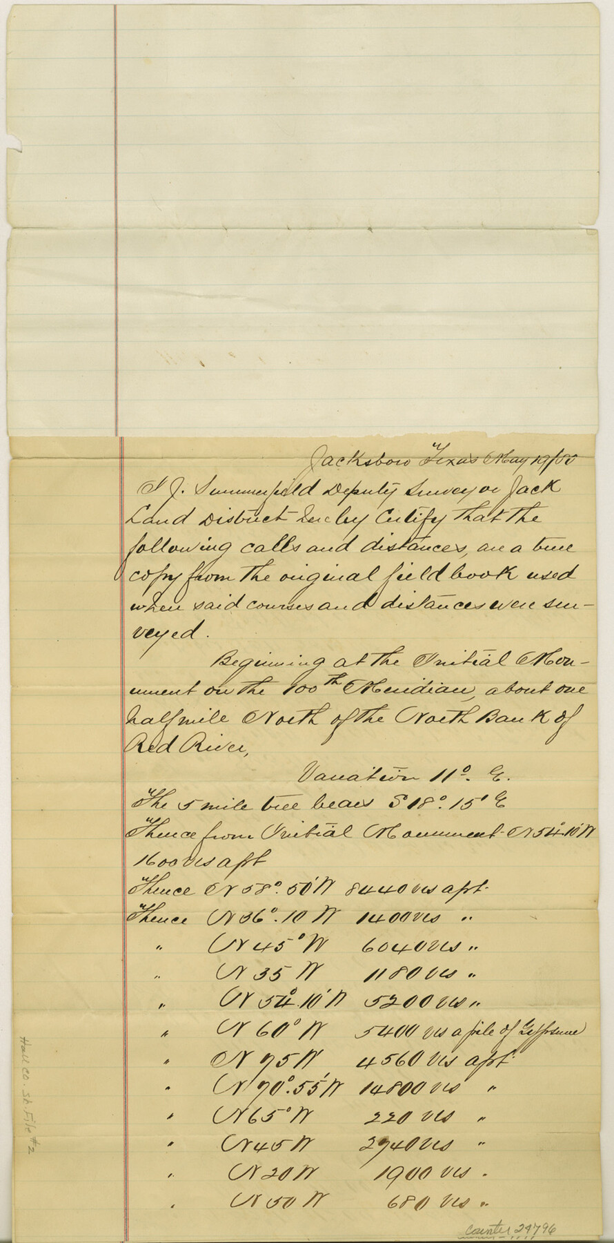
Hall County Sketch File 2
[Connecting line from initial monument]
-
Map/Doc
42261
-
Collection
General Map Collection
-
Object Dates
1880/5/19 (Creation Date)
1880/6/4 (File Date)
-
People and Organizations
Jonathan Summerfield (Surveyor/Engineer)
-
Counties
Hall
-
Subjects
Surveying Sketch File
-
Height x Width
17.1 x 8.4 inches
43.4 x 21.3 cm
-
Medium
paper, manuscript
-
Features
Red River
Hall's Creek
Mulberry Creek
Byrnes Fork
Battle Creek
Hackberry Creek
Part of: General Map Collection
Flight Mission No. BQR-14K, Frame 36, Brazoria County

Print $20.00
- Digital $50.00
Flight Mission No. BQR-14K, Frame 36, Brazoria County
1952
Size 18.6 x 22.3 inches
Map/Doc 84093
Grimes County Working Sketch 13

Print $20.00
- Digital $50.00
Grimes County Working Sketch 13
1982
Size 39.4 x 47.7 inches
Map/Doc 63304
Erath County Working Sketch 11

Print $20.00
- Digital $50.00
Erath County Working Sketch 11
1951
Size 45.1 x 36.2 inches
Map/Doc 69092
Stephens County Boundary File 6

Print $12.00
- Digital $50.00
Stephens County Boundary File 6
Size 13.0 x 8.5 inches
Map/Doc 58901

Flight Mission No. DCL-7C, Frame 111, Kenedy County

Print $20.00
- Digital $50.00
Flight Mission No. DCL-7C, Frame 111, Kenedy County
1943
Size 18.5 x 22.3 inches
Map/Doc 86076
Travis County Rolled Sketch 14

Print $20.00
- Digital $50.00
Travis County Rolled Sketch 14
1939
Size 30.5 x 22.3 inches
Map/Doc 8017
[Sketch for Mineral Application 13440]
![65674, [Sketch for Mineral Application 13440], General Map Collection](https://historictexasmaps.com/wmedia_w700/maps/65674-1.tif.jpg)
Print $40.00
- Digital $50.00
[Sketch for Mineral Application 13440]
Size 65.8 x 42.9 inches
Map/Doc 65674
[Letters to and from Maj. W. J. Powell regarding surveys of Texas and Pacific Ry. Lands west of the Pecos. Blks 53-55, Township 1 & 2 map within]
![2249, [Letters to and from Maj. W. J. Powell regarding surveys of Texas and Pacific Ry. Lands west of the Pecos. Blks 53-55, Township 1 & 2 map within], General Map Collection](https://historictexasmaps.com/wmedia_w700/pdf_converted_jpg/qi_pdf_thumbnail_1039.jpg)
Print $124.00
- Digital $50.00
[Letters to and from Maj. W. J. Powell regarding surveys of Texas and Pacific Ry. Lands west of the Pecos. Blks 53-55, Township 1 & 2 map within]
1934
Size 10.2 x 15.4 inches
Map/Doc 2249
Irion County Working Sketch 12

Print $20.00
- Digital $50.00
Irion County Working Sketch 12
1968
Size 15.9 x 24.9 inches
Map/Doc 66421
Collingsworth County

Print $20.00
- Digital $50.00
Collingsworth County
1971
Size 42.7 x 35.8 inches
Map/Doc 95460
Harris County Sketch File D

Print $4.00
- Digital $50.00
Harris County Sketch File D
1860
Size 8.1 x 4.9 inches
Map/Doc 25313
You may also like

Dimmit County Rolled Sketch 14

Print $40.00
- Digital $50.00
Dimmit County Rolled Sketch 14
1945
Size 56.6 x 36.0 inches
Map/Doc 8797
[Mrs. May Vinson Survey]
![91875, [Mrs. May Vinson Survey], Twichell Survey Records](https://historictexasmaps.com/wmedia_w700/maps/91875-1.tif.jpg)
Print $20.00
- Digital $50.00
[Mrs. May Vinson Survey]
Size 25.2 x 14.8 inches
Map/Doc 91875
Matagorda County NRC Article 33.136 Sketch 13

Print $22.00
- Digital $50.00
Matagorda County NRC Article 33.136 Sketch 13
Size 24.2 x 36.0 inches
Map/Doc 95720
Houston County Working Sketch 1

Print $20.00
- Digital $50.00
Houston County Working Sketch 1
Size 20.6 x 15.6 inches
Map/Doc 66231
[Channing Vacancy, Leagues 217- 235 and Vicinity]
![91483, [Channing Vacancy, Leagues 217- 235 and Vicinity], Twichell Survey Records](https://historictexasmaps.com/wmedia_w700/maps/91483-1.tif.jpg)
Print $20.00
- Digital $50.00
[Channing Vacancy, Leagues 217- 235 and Vicinity]
Size 26.7 x 27.6 inches
Map/Doc 91483

Carte du Canada et de la Louisiane qui forment la Nouvelle France et des colonies angloises ou sont representez les pays contestez

Print $20.00
- Digital $50.00
Carte du Canada et de la Louisiane qui forment la Nouvelle France et des colonies angloises ou sont representez les pays contestez
1756
Size 21.5 x 29.6 inches
Map/Doc 97415
[Map Showing Parmer, Castro, Bailey, Lamb, Cochran & Hockley Counties, Texas]
![1762, [Map Showing Parmer, Castro, Bailey, Lamb, Cochran & Hockley Counties, Texas], General Map Collection](https://historictexasmaps.com/wmedia_w700/maps/1762.tif.jpg)
Print $40.00
- Digital $50.00
[Map Showing Parmer, Castro, Bailey, Lamb, Cochran & Hockley Counties, Texas]
1910
Size 55.3 x 40.1 inches
Map/Doc 1762
[Heirs of Jno. Breeding and surrounding surveys]
![90494, [Heirs of Jno. Breeding and surrounding surveys], Twichell Survey Records](https://historictexasmaps.com/wmedia_w700/maps/90494-1.tif.jpg)
Print $3.00
- Digital $50.00
[Heirs of Jno. Breeding and surrounding surveys]
Size 10.5 x 16.1 inches
Map/Doc 90494
San Jacinto County Working Sketch 40

Print $40.00
- Digital $50.00
San Jacinto County Working Sketch 40
1971
Size 43.9 x 59.8 inches
Map/Doc 63753
Kendall County Sketch File 1a

Print $18.00
- Digital $50.00
Kendall County Sketch File 1a
1873
Size 5.3 x 6.7 inches
Map/Doc 28673