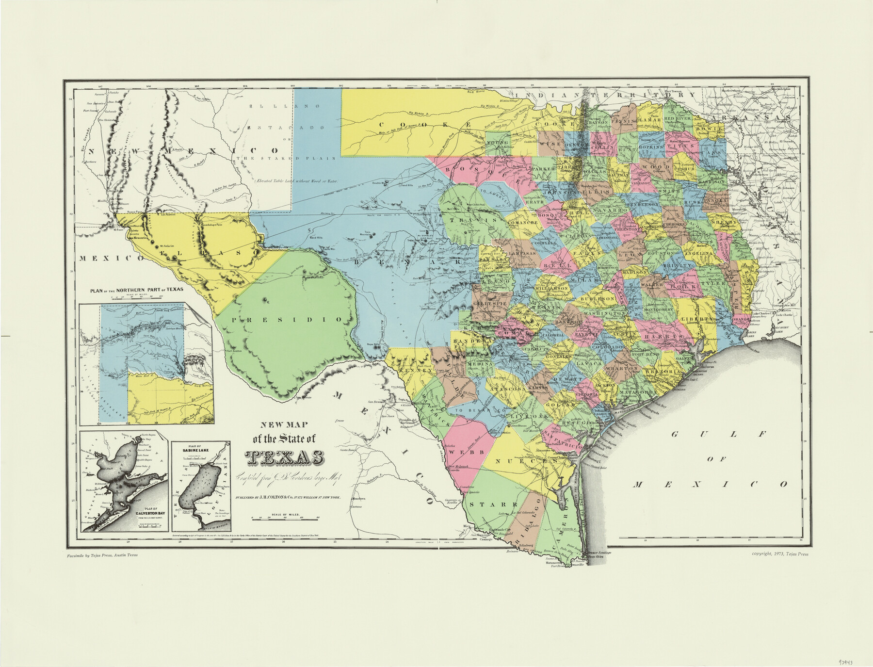
New Map of the State of Texas compiled from J. De Cordova's large map
-
Map/Doc
93943
-
Collection
General Map Collection
-
Object Dates
1855 (Creation Date)
2015/9/16 (File Date)
1973 (Copy/Tracing Date)
-
People and Organizations
J. H. Colton & Co. (Publisher)
-
Subjects
State of Texas
-
Comments
Facsimile published by Tejas Press in 1973 featuring added color.
Part of: General Map Collection


Bastrop County Sketch File 1a

Print $4.00
- Digital $50.00
Bastrop County Sketch File 1a
Size 8.4 x 12.8 inches
Map/Doc 14040
Crosby County Working Sketch 5

Print $20.00
- Digital $50.00
Crosby County Working Sketch 5
1911
Size 23.3 x 16.7 inches
Map/Doc 68439
Henderson County Sketch File 24

Print $20.00
- Digital $50.00
Henderson County Sketch File 24
1974
Size 27.4 x 24.1 inches
Map/Doc 11759
Map of the City of Beaumont, Texas

Print $20.00
- Digital $50.00
Map of the City of Beaumont, Texas
1897
Size 31.7 x 30.9 inches
Map/Doc 64146
Bell County Sketch File 31

Print $4.00
- Digital $50.00
Bell County Sketch File 31
1882
Size 8.0 x 8.9 inches
Map/Doc 14445

Gonzales County

Print $40.00
- Digital $50.00
Gonzales County
1920
Size 48.4 x 44.2 inches
Map/Doc 4706
Map of Extension Line from the Brazos River to the Waters of the Colorado River of the Memphis, El Paso & Pacific R.R. Company Land Reserve

Print $40.00
- Digital $50.00
Map of Extension Line from the Brazos River to the Waters of the Colorado River of the Memphis, El Paso & Pacific R.R. Company Land Reserve
1858
Size 16.8 x 82.9 inches
Map/Doc 64093

Matagorda County Sketch File 39

Print $20.00
- Digital $50.00
Matagorda County Sketch File 39
Size 31.1 x 24.3 inches
Map/Doc 12047
You may also like
Pecos County Working Sketch 89

Print $20.00
- Digital $50.00
Pecos County Working Sketch 89
1964
Size 46.5 x 34.2 inches
Map/Doc 78216
Montgomery County Sketch File 28

Print $22.00
- Digital $50.00
Montgomery County Sketch File 28
Size 14.1 x 8.7 inches
Map/Doc 31873
Winkler County Working Sketch 4

Print $20.00
- Digital $50.00
Winkler County Working Sketch 4
1954
Size 36.7 x 30.1 inches
Map/Doc 72598
Donley County Working Sketch 10

Print $20.00
- Digital $50.00
Donley County Working Sketch 10
1982
Size 35.1 x 41.1 inches
Map/Doc 68743
The Judicial District/County of Pashcal. June 24, 1841

Print $20.00
The Judicial District/County of Pashcal. June 24, 1841
2020
Size 15.0 x 21.7 inches
Map/Doc 96344
Map of the Survey of the 100th Meridian of Longitude west of Greenwich beginning at Red River and extending to the parallel 36 1/2 degrees north latitude

Print $40.00
- Digital $50.00
Map of the Survey of the 100th Meridian of Longitude west of Greenwich beginning at Red River and extending to the parallel 36 1/2 degrees north latitude
Size 11.4 x 111.7 inches
Map/Doc 93191
Duval County Sketch File 6a

Print $20.00
- Digital $50.00
Duval County Sketch File 6a
1875
Size 10.9 x 22.9 inches
Map/Doc 11382
La Salle County Sketch File 22

Print $4.00
- Digital $50.00
La Salle County Sketch File 22
1875
Size 12.8 x 8.2 inches
Map/Doc 29528
Jefferson County Sketch File 10

Print $32.00
- Digital $50.00
Jefferson County Sketch File 10
Size 8.0 x 6.8 inches
Map/Doc 28125
Right of Way and Track Map International & Gt Northern Ry. operated by the International & Gt. Northern Ry. Co., San Antonio Division

Print $40.00
- Digital $50.00
Right of Way and Track Map International & Gt Northern Ry. operated by the International & Gt. Northern Ry. Co., San Antonio Division
1917
Size 25.5 x 57.3 inches
Map/Doc 64589
Webb County Sketch File 13a

Print $20.00
- Digital $50.00
Webb County Sketch File 13a
1881
Size 19.0 x 25.7 inches
Map/Doc 12631
Flight Mission No. BRE-1P, Frame 102, Nueces County

Print $20.00
- Digital $50.00
Flight Mission No. BRE-1P, Frame 102, Nueces County
1956
Size 18.5 x 22.4 inches
Map/Doc 86673