![72705, [Gulf Coast of Texas], General Map Collection](https://historictexasmaps.com/wmedia_w1800h1800/maps/72705.tif.jpg)
[Gulf Coast of Texas]
RL-1-9b
-
Map/Doc
72705
-
Collection
General Map Collection
-
Object Dates
1881 (Creation Date)
-
Subjects
Gulf of Mexico
-
Height x Width
28.7 x 18.2 inches
72.9 x 46.2 cm
-
Comments
B/W photostat copy from National Archives in multiple pieces.
Part of: General Map Collection
Crockett County Rolled Sketch 75

Print $20.00
- Digital $50.00
Crockett County Rolled Sketch 75
1949
Size 17.6 x 21.1 inches
Map/Doc 5616
Travis County Sketch File 3

Print $4.00
- Digital $50.00
Travis County Sketch File 3
Size 12.9 x 7.9 inches
Map/Doc 38273
Reagan County Sketch File 5

Print $12.00
- Digital $50.00
Reagan County Sketch File 5
1927
Size 11.2 x 8.7 inches
Map/Doc 34980
Map of Colorado District

Print $20.00
- Digital $50.00
Map of Colorado District
1841
Size 21.5 x 31.2 inches
Map/Doc 3421
Shelby County Sketch File 27

Print $4.00
- Digital $50.00
Shelby County Sketch File 27
Size 6.5 x 8.0 inches
Map/Doc 36662
Edwards County Rolled Sketch O

Print $20.00
- Digital $50.00
Edwards County Rolled Sketch O
Size 13.6 x 18.3 inches
Map/Doc 5820
Northern Part of Laguna Madre
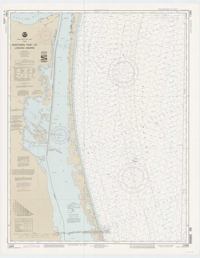
Print $20.00
- Digital $50.00
Northern Part of Laguna Madre
1992
Size 45.4 x 35.3 inches
Map/Doc 73532
Jefferson County

Print $20.00
- Digital $50.00
Jefferson County
1882
Size 22.8 x 20.0 inches
Map/Doc 3730
McLennan County Sketch File 2

Print $6.00
- Digital $50.00
McLennan County Sketch File 2
1856
Size 11.5 x 7.7 inches
Map/Doc 31230
Kenedy County

Print $20.00
- Digital $50.00
Kenedy County
1913
Size 41.0 x 31.8 inches
Map/Doc 66888
Hopkins County

Print $20.00
- Digital $50.00
Hopkins County
1942
Size 44.1 x 40.9 inches
Map/Doc 73183
West Part Presidio Co.

Print $20.00
- Digital $50.00
West Part Presidio Co.
1974
Size 43.2 x 34.3 inches
Map/Doc 95618
You may also like
Rusk County Working Sketch 38

Print $20.00
- Digital $50.00
Rusk County Working Sketch 38
2008
Size 16.3 x 23.3 inches
Map/Doc 88815
Jasper County Working Sketch 26

Print $20.00
- Digital $50.00
Jasper County Working Sketch 26
1953
Size 23.1 x 18.1 inches
Map/Doc 66488
General Highway Map. Detail of Cities and Towns in Grimes County, Texas

Print $20.00
General Highway Map. Detail of Cities and Towns in Grimes County, Texas
1961
Size 18.2 x 24.8 inches
Map/Doc 79491
Amerique Septentrionale

Print $20.00
- Digital $50.00
Amerique Septentrionale
1650
Size 17.2 x 23.1 inches
Map/Doc 93684
Scurry County Working Sketch 3

Print $20.00
- Digital $50.00
Scurry County Working Sketch 3
1941
Size 20.7 x 12.4 inches
Map/Doc 63832

Tom Green County Rolled Sketch 1

Print $20.00
- Digital $50.00
Tom Green County Rolled Sketch 1
Size 29.8 x 25.4 inches
Map/Doc 7991
Panola County Working Sketch 23

Print $20.00
- Digital $50.00
Panola County Working Sketch 23
1951
Map/Doc 71432
No. 3 Chart of Channel connecting Corpus Christi Bay with Aransas Bay, Texas

Print $20.00
- Digital $50.00
No. 3 Chart of Channel connecting Corpus Christi Bay with Aransas Bay, Texas
1878
Size 18.3 x 27.3 inches
Map/Doc 72781
General Highway Map, Callahan County, Texas

Print $20.00
General Highway Map, Callahan County, Texas
1940
Size 25.3 x 18.4 inches
Map/Doc 79037
Chambers County Boundary File 50

Print $42.00
- Digital $50.00
Chambers County Boundary File 50
Size 9.2 x 3.6 inches
Map/Doc 51267
Mitchell County Working Sketch 8

Print $20.00
- Digital $50.00
Mitchell County Working Sketch 8
1975
Size 31.9 x 26.3 inches
Map/Doc 71065