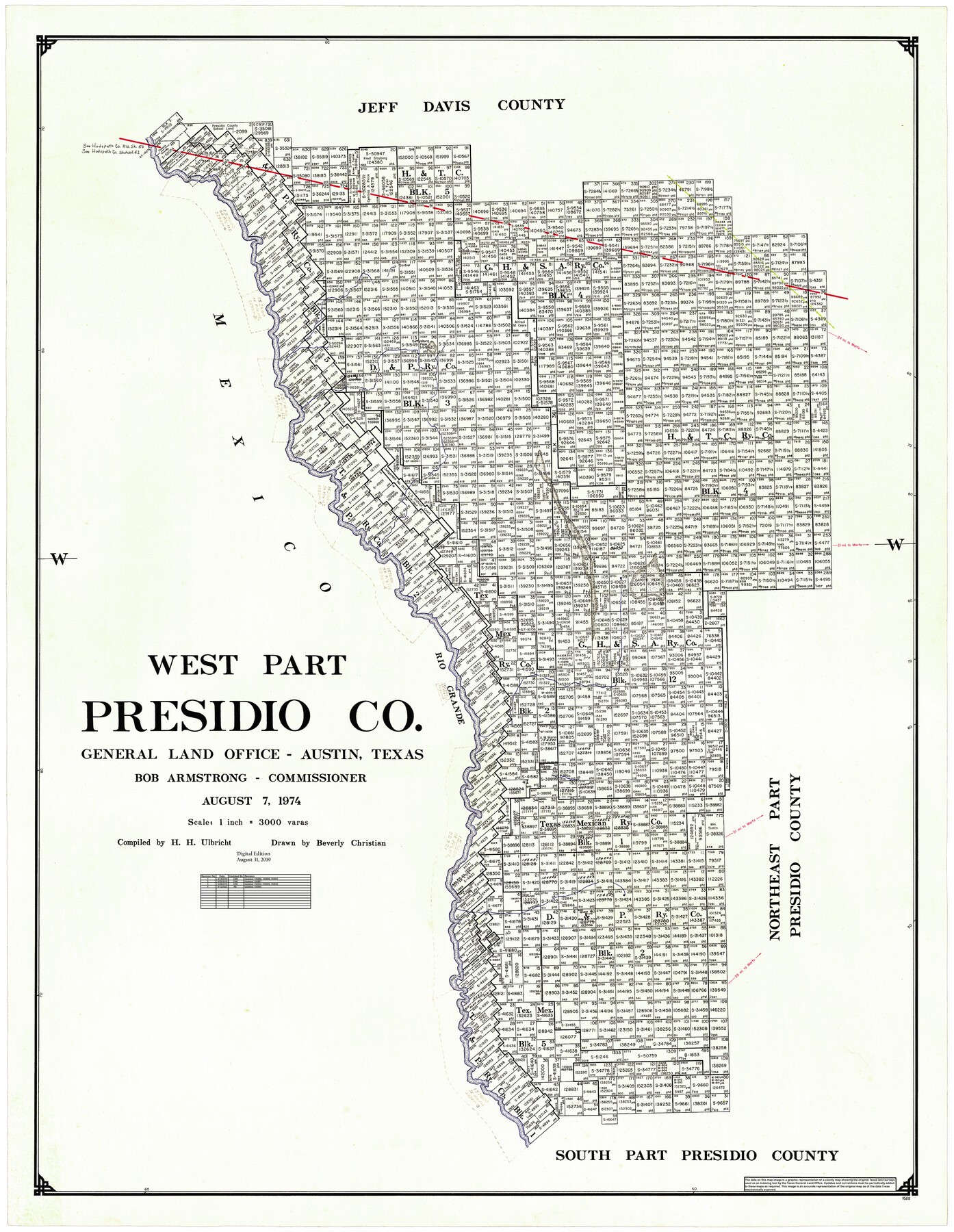
West Part Presidio Co.
General Land Office Official County Map
-
Map/Doc
95618
-
Collection
General Map Collection
-
Object Dates
8/7/1974 (Creation Date)
8/31/2019 (Revision Date)
6/14/2019 (Revision Date)
6/25/2019 (Revision Date)
6/26/2019 (Revision Date)
9/12/2022 (Revision Date)
-
People and Organizations
Cheyenne Betancourt (Draftsman)
Beverly Christian (Draftsman)
Herbert H. Ulbricht (Compiler)
Bob Armstrong (GLO Commissioner)
Kat Bird (Draftsman)
-
Counties
Presidio
-
Subjects
County OCM
-
Height x Width
43.2 x 34.3 inches
109.7 x 87.1 cm
-
Medium
digital image
-
Scale
1" = 3000 varas
-
Comments
For northeast part of Presidio County see 95616 and for south part of Presidio County see 95617.
Related maps
Northeast Part Presidio County

Print $20.00
- Digital $50.00
Northeast Part Presidio County
1973
Size 42.3 x 33.4 inches
Map/Doc 95616
South Part Presidio County

Print $20.00
- Digital $50.00
South Part Presidio County
1975
Size 35.0 x 40.3 inches
Map/Doc 95617
Part of: General Map Collection
Reeves County Working Sketch 55

Print $20.00
- Digital $50.00
Reeves County Working Sketch 55
1978
Size 36.1 x 34.7 inches
Map/Doc 63498
Presidio County Working Sketch 43

Print $40.00
- Digital $50.00
Presidio County Working Sketch 43
1949
Size 29.0 x 54.9 inches
Map/Doc 71720
Jasper County Rolled Sketch 9

Print $83.00
- Digital $50.00
Jasper County Rolled Sketch 9
1932
Size 10.7 x 15.4 inches
Map/Doc 46171
Flight Mission No. DAG-21K, Frame 28, Matagorda County

Print $20.00
- Digital $50.00
Flight Mission No. DAG-21K, Frame 28, Matagorda County
1952
Size 18.6 x 22.4 inches
Map/Doc 86395
The City of Austin and Suburbs

Print $40.00
- Digital $50.00
The City of Austin and Suburbs
1919
Size 120.7 x 73.5 inches
Map/Doc 2204
Blanco County Working Sketch 10

Print $20.00
- Digital $50.00
Blanco County Working Sketch 10
1938
Size 28.3 x 25.8 inches
Map/Doc 67370
Webb County Rolled Sketch 47

Print $20.00
- Digital $50.00
Webb County Rolled Sketch 47
Size 23.5 x 31.7 inches
Map/Doc 8203
Map of Rusk County

Print $20.00
- Digital $50.00
Map of Rusk County
1846
Size 31.6 x 20.6 inches
Map/Doc 4006
Map of Shackelford County

Print $20.00
- Digital $50.00
Map of Shackelford County
1895
Size 24.1 x 19.5 inches
Map/Doc 4026
Kinney County Rolled Sketch 15

Print $20.00
- Digital $50.00
Kinney County Rolled Sketch 15
Size 28.2 x 43.4 inches
Map/Doc 9354
Flight Mission No. CUG-3P, Frame 132, Kleberg County

Print $20.00
- Digital $50.00
Flight Mission No. CUG-3P, Frame 132, Kleberg County
1956
Size 18.4 x 22.4 inches
Map/Doc 86267
Panola County Working Sketch 26

Print $20.00
- Digital $50.00
Panola County Working Sketch 26
1958
Map/Doc 71435
You may also like
Crockett County Rolled Sketch 88E

Print $40.00
- Digital $50.00
Crockett County Rolled Sketch 88E
1973
Size 44.4 x 30.6 inches
Map/Doc 8730
Milam County Boundary File 1

Print $8.00
- Digital $50.00
Milam County Boundary File 1
Size 12.7 x 8.2 inches
Map/Doc 57198
Shackelford County Boundary File 6

Print $6.00
- Digital $50.00
Shackelford County Boundary File 6
Size 11.4 x 8.8 inches
Map/Doc 58668
Crosby County Working Sketch 10

Print $20.00
- Digital $50.00
Crosby County Working Sketch 10
1946
Size 44.5 x 23.7 inches
Map/Doc 68444
Ellis County Sketch File 2

Print $11.00
- Digital $50.00
Ellis County Sketch File 2
1858
Size 8.4 x 9.7 inches
Map/Doc 21827
San Patricio County Rolled Sketch 38

Print $20.00
- Digital $50.00
San Patricio County Rolled Sketch 38
1950
Size 15.6 x 15.7 inches
Map/Doc 7588
Working Sketch in Childress County

Print $20.00
- Digital $50.00
Working Sketch in Childress County
1910
Size 6.6 x 23.3 inches
Map/Doc 90425
Plan of the Battle of Buena-Vista fought February 22nd and 23rd, 1847

Print $20.00
- Digital $50.00
Plan of the Battle of Buena-Vista fought February 22nd and 23rd, 1847
1847
Size 17.8 x 21.5 inches
Map/Doc 94112
Kimble County

Print $40.00
- Digital $50.00
Kimble County
1890
Size 37.4 x 58.6 inches
Map/Doc 16866
[Sketch from Paul McCombs Map of 1884, showing T. & P. Township 5, Block 60, Township 6, Block 59, and Township 7, Blocks 59 and 60]
![91774, [Sketch from Paul McCombs Map of 1884, showing T. & P. Township 5, Block 60, Township 6, Block 59, and Township 7, Blocks 59 and 60], Twichell Survey Records](https://historictexasmaps.com/wmedia_w700/maps/91774-1.tif.jpg)
Print $2.00
- Digital $50.00
[Sketch from Paul McCombs Map of 1884, showing T. & P. Township 5, Block 60, Township 6, Block 59, and Township 7, Blocks 59 and 60]
Size 9.2 x 15.0 inches
Map/Doc 91774
![93063, [Block B11], Twichell Survey Records](https://historictexasmaps.com/wmedia_w700/maps/93063-1.tif.jpg)
Flight Mission No. DAG-23K, Frame 13, Matagorda County

Print $20.00
- Digital $50.00
Flight Mission No. DAG-23K, Frame 13, Matagorda County
1953
Size 18.5 x 22.2 inches
Map/Doc 86475