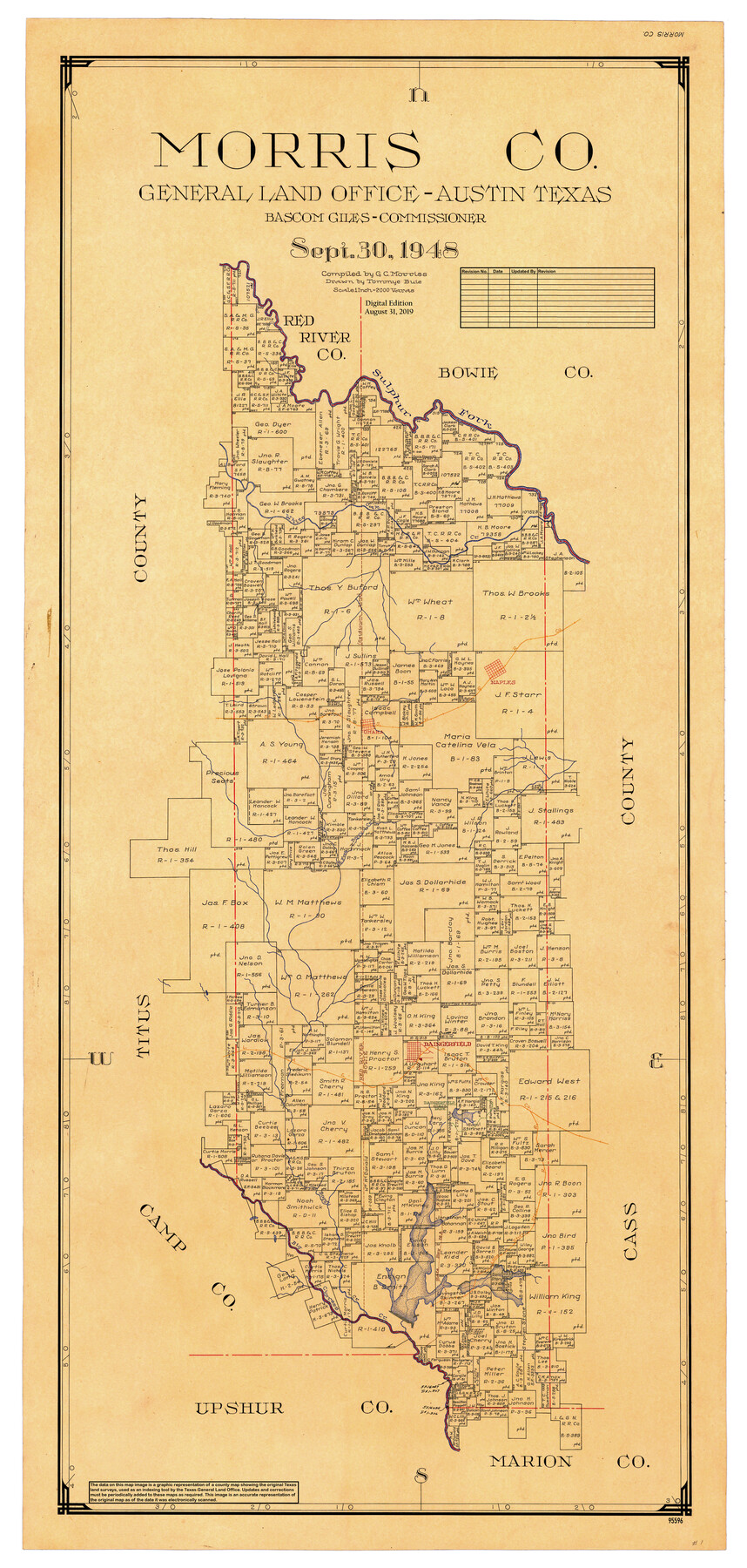
Morris Co.
General Land Office Official County Map
-
Map/Doc
95596
-
Collection
General Map Collection
-
Object Dates
9/30/1948 (Creation Date)
8/31/2019 (Revision Date)
-
People and Organizations
Bascom Giles (GLO Commissioner)
G.C. Morriss (Compiler)
Tommye Buie (Draftsman)
Cheyenne Betancourt (Draftsman)
-
Counties
Morris
-
Subjects
County OCM
-
Height x Width
45.1 x 21.5 inches
114.6 x 54.6 cm
-
Medium
digital image
-
Scale
1" = 2000 varas
Part of: General Map Collection
Stonewall County Rolled Sketch 24B

Print $40.00
- Digital $50.00
Stonewall County Rolled Sketch 24B
1954
Size 50.1 x 43.1 inches
Map/Doc 9964
Aransas County Rolled Sketch 27B

Print $2.00
- Digital $50.00
Aransas County Rolled Sketch 27B
1958
Size 9.1 x 9.1 inches
Map/Doc 5057
Young Land District

Print $20.00
- Digital $50.00
Young Land District
1857
Size 21.7 x 29.7 inches
Map/Doc 1974
West Part of Liberty Co.

Print $20.00
- Digital $50.00
West Part of Liberty Co.
1977
Size 43.5 x 32.9 inches
Map/Doc 77353
Collingsworth County

Print $20.00
- Digital $50.00
Collingsworth County
1971
Size 42.7 x 35.8 inches
Map/Doc 95460
Flight Mission No. DQN-2K, Frame 39, Calhoun County

Print $20.00
- Digital $50.00
Flight Mission No. DQN-2K, Frame 39, Calhoun County
1953
Size 18.2 x 22.2 inches
Map/Doc 84244
Travis County Working Sketch 25

Print $20.00
- Digital $50.00
Travis County Working Sketch 25
1948
Size 26.4 x 32.0 inches
Map/Doc 69409
Flight Mission No. CRE-1R, Frame 63, Jackson County

Print $20.00
- Digital $50.00
Flight Mission No. CRE-1R, Frame 63, Jackson County
1956
Size 18.6 x 18.9 inches
Map/Doc 85326
Travis County Rolled Sketch 33

Print $20.00
- Digital $50.00
Travis County Rolled Sketch 33
Size 22.7 x 32.7 inches
Map/Doc 8034
Gulf of Mexico

Print $20.00
- Digital $50.00
Gulf of Mexico
1908
Size 18.2 x 27.9 inches
Map/Doc 72659
Cameron County Rolled Sketch 20D

Print $20.00
- Digital $50.00
Cameron County Rolled Sketch 20D
Size 13.7 x 12.1 inches
Map/Doc 5476
Padre Island Under Six Flags

Print $40.00
- Digital $50.00
Padre Island Under Six Flags
1962
Size 59.3 x 30.3 inches
Map/Doc 3123
You may also like
Flight Mission No. DCL-6C, Frame 29, Kenedy County

Print $20.00
- Digital $50.00
Flight Mission No. DCL-6C, Frame 29, Kenedy County
1943
Size 18.6 x 22.4 inches
Map/Doc 85886
[Atlas D, Table of Contents]
![78350, [Atlas D, Table of Contents], General Map Collection](https://historictexasmaps.com/wmedia_w700/maps/78350.tif.jpg)
Print $20.00
- Digital $50.00
[Atlas D, Table of Contents]
Size 18.3 x 9.5 inches
Map/Doc 78350
[Sketch for Mineral Applications 26885-6 - Reagan and Crockett Cos., W. H. Bland]
![2854, [Sketch for Mineral Applications 26885-6 - Reagan and Crockett Cos., W. H. Bland], General Map Collection](https://historictexasmaps.com/wmedia_w700/maps/2854.tif.jpg)
Print $20.00
- Digital $50.00
[Sketch for Mineral Applications 26885-6 - Reagan and Crockett Cos., W. H. Bland]
1932
Size 41.5 x 36.6 inches
Map/Doc 2854
Terrell County Sketch File 13

Print $20.00
- Digital $50.00
Terrell County Sketch File 13
1911
Size 13.7 x 20.4 inches
Map/Doc 12420
Wise County Sketch File 31

Print $12.00
- Digital $50.00
Wise County Sketch File 31
1877
Size 13.1 x 8.1 inches
Map/Doc 40582
Map of the Lands Surveyed by the Memphis, El Paso & Pacific R.R. Company

Print $20.00
- Digital $50.00
Map of the Lands Surveyed by the Memphis, El Paso & Pacific R.R. Company
1859
Size 13.9 x 21.3 inches
Map/Doc 4849
Stonewall County Sketch File 11

Print $6.00
- Digital $50.00
Stonewall County Sketch File 11
1900
Size 9.7 x 8.5 inches
Map/Doc 37237
Bastrop County

Print $20.00
- Digital $50.00
Bastrop County
1917
Size 45.5 x 40.8 inches
Map/Doc 66711
Pecos County Working Sketch 23

Print $20.00
- Digital $50.00
Pecos County Working Sketch 23
1927
Size 45.6 x 40.6 inches
Map/Doc 71494
Hidalgo County Sketch File 12

Print $20.00
- Digital $50.00
Hidalgo County Sketch File 12
Size 16.3 x 25.1 inches
Map/Doc 11763
Donley County Sketch File B7

Print $20.00
- Digital $50.00
Donley County Sketch File B7
1919
Size 25.5 x 32.4 inches
Map/Doc 11377
Intracoastal Waterway in Texas - Corpus Christi to Point Isabel including Arroyo Colorado to Mo. Pac. R.R. Bridge Near Harlingen

Print $20.00
- Digital $50.00
Intracoastal Waterway in Texas - Corpus Christi to Point Isabel including Arroyo Colorado to Mo. Pac. R.R. Bridge Near Harlingen
1934
Size 21.5 x 32.4 inches
Map/Doc 61883