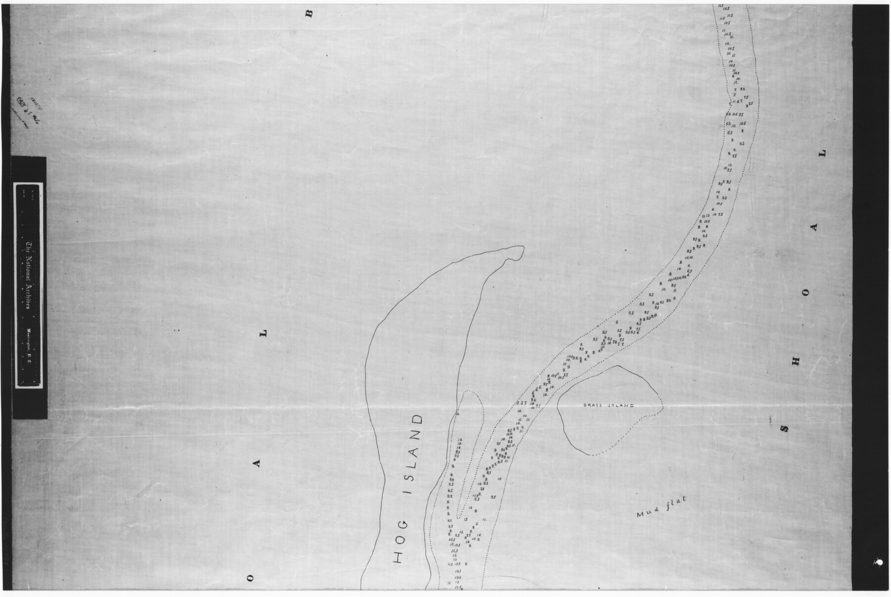
No. 3 Chart of Channel connecting Corpus Christi Bay with Aransas Bay, Texas
RL-2-8
-
Map/Doc
72781
-
Collection
General Map Collection
-
Object Dates
1878/9/17 (Creation Date)
-
People and Organizations
Corps of Engineers (Author)
H.C. Collins (Surveyor/Engineer)
H.S. Douglas (Surveyor/Engineer)
W.H. Hoffman (Surveyor/Engineer)
-
Counties
Nueces
-
Subjects
Nautical Charts
-
Height x Width
18.3 x 27.3 inches
46.5 x 69.3 cm
-
Comments
B/W photostat copy from National Archives in multiple pieces.
Part of: General Map Collection
Map of La Salle County

Print $20.00
- Digital $50.00
Map of La Salle County
1879
Size 26.2 x 25.3 inches
Map/Doc 3799
Copy of Surveyor's Field Book, Morris Browning - In Blocks 7, 5 & 4, I&GNRRCo., Hutchinson and Carson Counties, Texas

Print $2.00
- Digital $50.00
Copy of Surveyor's Field Book, Morris Browning - In Blocks 7, 5 & 4, I&GNRRCo., Hutchinson and Carson Counties, Texas
1888
Size 7.0 x 8.8 inches
Map/Doc 62286
Galveston Co.

Print $40.00
- Digital $50.00
Galveston Co.
1891
Size 38.5 x 53.8 inches
Map/Doc 66834
Cameron County Rolled Sketch 25

Print $20.00
- Digital $50.00
Cameron County Rolled Sketch 25
1977
Size 24.8 x 36.6 inches
Map/Doc 5798
Nacogdoches County Working Sketch 7

Print $20.00
- Digital $50.00
Nacogdoches County Working Sketch 7
1962
Size 24.1 x 21.7 inches
Map/Doc 71223
Clay County Boundary File 12

Print $8.00
- Digital $50.00
Clay County Boundary File 12
Size 14.3 x 8.8 inches
Map/Doc 51406
Flight Mission No. BRA-6M, Frame 146, Jefferson County

Print $20.00
- Digital $50.00
Flight Mission No. BRA-6M, Frame 146, Jefferson County
1953
Size 18.6 x 22.3 inches
Map/Doc 85447
Houston Ship Channel, Atkinson Island to Alexander Island

Print $40.00
- Digital $50.00
Houston Ship Channel, Atkinson Island to Alexander Island
1972
Size 36.9 x 50.0 inches
Map/Doc 69901
Plan of the Battle of Buena-Vista fought February 22nd and 23rd, 1847

Print $20.00
- Digital $50.00
Plan of the Battle of Buena-Vista fought February 22nd and 23rd, 1847
1847
Size 17.8 x 21.5 inches
Map/Doc 94112
Dallas, Ft. Worth, & Vicinity, Texas - Regional Map

Dallas, Ft. Worth, & Vicinity, Texas - Regional Map
1997
Size 25.9 x 36.7 inches
Map/Doc 97288
Ward County Rolled Sketch 23

Print $20.00
- Digital $50.00
Ward County Rolled Sketch 23
1955
Size 31.5 x 37.5 inches
Map/Doc 10111
Newton County Sketch File 47

Print $20.00
- Digital $50.00
Newton County Sketch File 47
1932
Size 18.9 x 21.9 inches
Map/Doc 42159
You may also like
Flight Mission No. DAG-21K, Frame 124, Matagorda County

Print $20.00
- Digital $50.00
Flight Mission No. DAG-21K, Frame 124, Matagorda County
1952
Size 18.5 x 22.4 inches
Map/Doc 86450
La Salle County Rolled Sketch 3

Print $20.00
- Digital $50.00
La Salle County Rolled Sketch 3
1937
Size 32.6 x 38.9 inches
Map/Doc 6568
Erath County Sketch File 7

Print $4.00
- Digital $50.00
Erath County Sketch File 7
Size 6.8 x 7.3 inches
Map/Doc 22267
Rio Grande, Willamar Sheet

Print $20.00
- Digital $50.00
Rio Grande, Willamar Sheet
1937
Size 36.9 x 37.2 inches
Map/Doc 65111
Flight Mission No. BRE-2P, Frame 63, Nueces County

Print $20.00
- Digital $50.00
Flight Mission No. BRE-2P, Frame 63, Nueces County
1956
Size 18.5 x 22.5 inches
Map/Doc 86758
San Jacinto County Working Sketch 45

Print $20.00
- Digital $50.00
San Jacinto County Working Sketch 45
1986
Size 41.0 x 46.7 inches
Map/Doc 63759
[Young Territory]
![16784, [Young Territory], General Map Collection](https://historictexasmaps.com/wmedia_w700/maps/16784.tif.jpg)
Print $40.00
- Digital $50.00
[Young Territory]
1875
Size 49.0 x 87.4 inches
Map/Doc 16784
Waller County Working Sketch Graphic Index

Print $20.00
- Digital $50.00
Waller County Working Sketch Graphic Index
1945
Size 46.7 x 27.2 inches
Map/Doc 76730
Garza County Sketch File 32

Print $28.00
- Digital $50.00
Garza County Sketch File 32
1932
Size 8.9 x 14.3 inches
Map/Doc 24109
Gaines County Rolled Sketch 13

Print $40.00
- Digital $50.00
Gaines County Rolled Sketch 13
Size 70.1 x 23.1 inches
Map/Doc 9029
Briscoe County Sketch File 3

Print $40.00
- Digital $50.00
Briscoe County Sketch File 3
1885
Size 22.6 x 20.7 inches
Map/Doc 10992
Bandera County Rolled Sketch 8

Print $20.00
- Digital $50.00
Bandera County Rolled Sketch 8
Size 27.9 x 26.4 inches
Map/Doc 5119