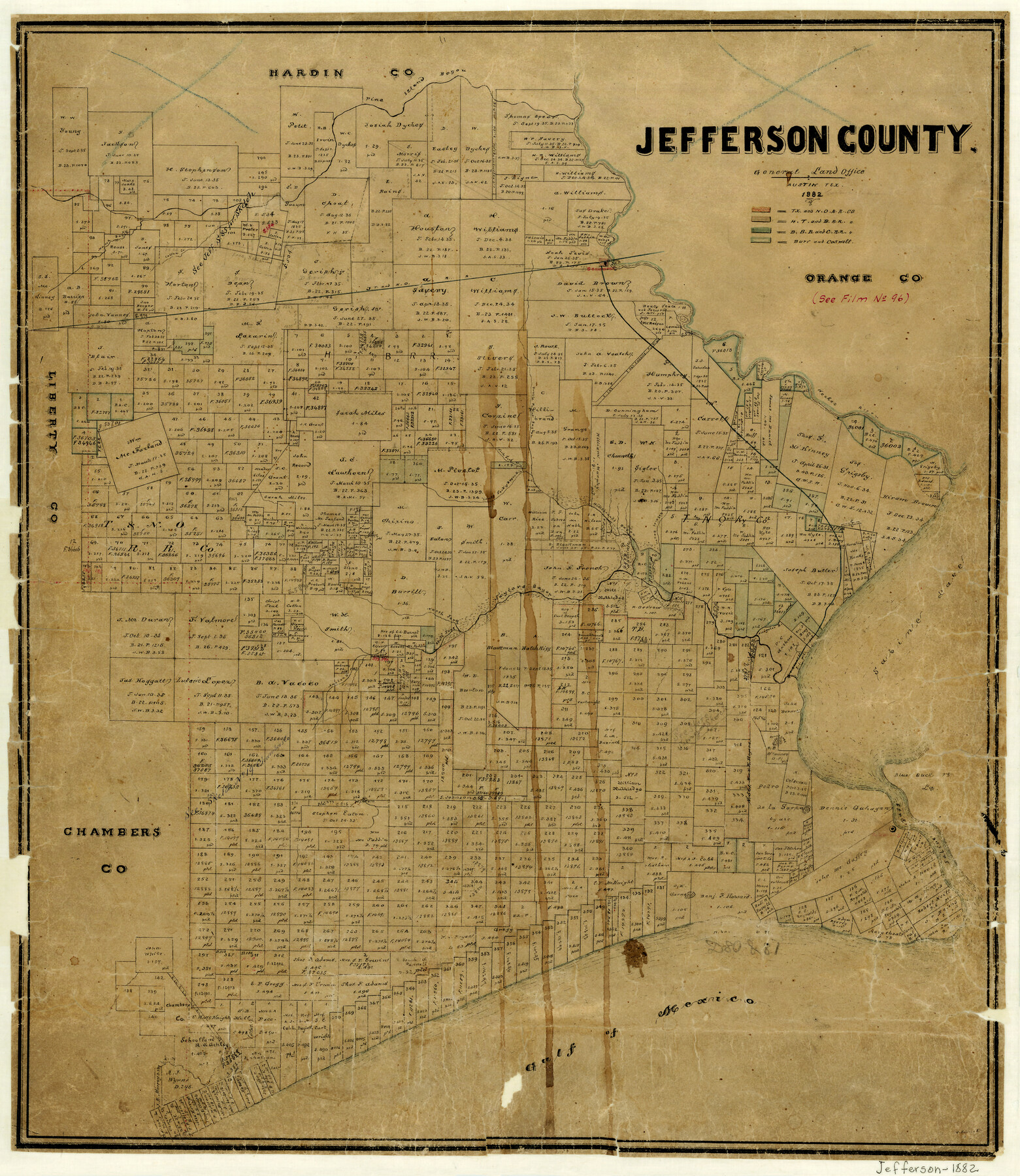
Jefferson County
- 
                          Map/Doc
3730
 - 
                            Collection
General Map Collection
 - 
                            Object Dates
1882 (Creation Date)
 - 
                            People and Organizations
V. Schmidt (Draftsman)
 - 
                            Counties
Jefferson
 - 
                            Subjects
County
 - 
                            Height x Width
22.8 x 20.0 inches
57.9 x 50.8 cm
 - 
                            Features
Rodairs Bayou
JT&NO
Gulf of Mexico
Sabine Pass
Blue Buck Lake
Blue Buck Point
Round Lake
South Fork of Taylors Bayou
North Fork of Taylors Bayou
Alligator Bayou
Sabine Lake
Pine Island Bayou
Hillebrands Bayou
South Fork of Bayou Din
North Fork of Bayou Din
Double Point Bayou
Marsh Bayou
Cotton Creek
T&NO
Beaumont
Neches River
 
Part of: General Map Collection
            Map of Surveys Made for the T&PRRCo in Tom Green & Martin Counties, Blocks 40, 41, 42, 43, 44, 45 & 46, Reserve West of the Colorado


                                            Print $20.00                    
                                             -                         Digital $50.00                                    
                Map of Surveys Made for the T&PRRCo in Tom Green & Martin Counties, Blocks 40, 41, 42, 43, 44, 45 & 46, Reserve West of the Colorado
1876
Size 42.3 x 46.0 inches
                                Map/Doc 2227
            
            Fractional Township No. 7 South Range No. 1 West of the Indian Meridian, Indian Territory


                                            Print $20.00                    
                                             -                         Digital $50.00                                    
                Fractional Township No. 7 South Range No. 1 West of the Indian Meridian, Indian Territory
1898
Size 19.2 x 24.4 inches
                                Map/Doc 75197
            
            Mason County Sketch File 21A


                                            Print $20.00                    
                                             -                         Digital $50.00                                    
                Mason County Sketch File 21A
1932
Size 19.2 x 26.6 inches
                                Map/Doc 12037
            
            Stonewall County Working Sketch 15


                                            Print $20.00                    
                                             -                         Digital $50.00                                    
                Stonewall County Working Sketch 15
1954
Size 32.3 x 30.8 inches
                                Map/Doc 62322
            
            [Jacob Masters league and those adjoining and Surveys on Elkhart Creek]


                                            Print $20.00                    
                                             -                         Digital $50.00                                    
                [Jacob Masters league and those adjoining and Surveys on Elkhart Creek]
1846
Size 20.3 x 8.0 inches
                                Map/Doc 183
            
            Zavala County Sketch File 10


                                            Print $20.00                    
                                             -                         Digital $50.00                                    
                Zavala County Sketch File 10
Size 17.6 x 25.7 inches
                                Map/Doc 12728
            
            Upton County Boundary File 1


                                            Print $5.00                    
                                             -                         Digital $50.00                                    
                Upton County Boundary File 1
Size 13.4 x 9.0 inches
                                Map/Doc 59506
            
            Midland County Rolled Sketch 8


                                            Print $80.00                    
                                             -                         Digital $50.00                                    
                Midland County Rolled Sketch 8
1952
Size 39.8 x 17.8 inches
                                Map/Doc 6765
            
            Tarrant County Sketch File 21a


                                            Print $4.00                    
                                             -                         Digital $50.00                                    
                Tarrant County Sketch File 21a
1859
Size 8.0 x 8.1 inches
                                Map/Doc 37727
            
            Tom Green County Rolled Sketch 28


                                            Print $20.00                    
                                             -                         Digital $50.00                                    
                Tom Green County Rolled Sketch 28
Size 25.3 x 25.4 inches
                                Map/Doc 8008
            
            Wichita County Sketch File D


                                            Print $22.00                    
                                             -                         Digital $50.00                                    
                Wichita County Sketch File D
1919
Size 12.0 x 8.6 inches
                                Map/Doc 40061
            
            Bosque County Sketch File 4


                                            Print $4.00                    
                                             -                         Digital $50.00                                    
                Bosque County Sketch File 4
1854
Size 11.3 x 7.8 inches
                                Map/Doc 14744
            You may also like
            [Surveying Sketch of Francisco Guerra, Antonio Ramirez, Diego Ynojosa, et al on Rio Grande, Starr County]


                                            Print $20.00                    
                                             -                         Digital $50.00                                    
                [Surveying Sketch of Francisco Guerra, Antonio Ramirez, Diego Ynojosa, et al on Rio Grande, Starr County]
1914
Size 21.7 x 13.0 inches
                                Map/Doc 5073
            
            Real County Working Sketch 42


                                            Print $20.00                    
                                             -                         Digital $50.00                                    
                Real County Working Sketch 42
1953
Size 40.3 x 34.5 inches
                                Map/Doc 71934
            
            Current Miscellaneous File 27


                                            Print $4.00                    
                                             -                         Digital $50.00                                    
                Current Miscellaneous File 27
1952
Size 10.8 x 8.3 inches
                                Map/Doc 73909
            
            Gulf Intracoastal Waterway - High Island to Chocolate Bay, Location of Spoil Disposal Areas


                                            Print $20.00                    
                                             -                         Digital $50.00                                    
                Gulf Intracoastal Waterway - High Island to Chocolate Bay, Location of Spoil Disposal Areas
1961
Size 31.1 x 40.8 inches
                                Map/Doc 61830
            
            Topographical Map of the Rio Grande, Sheet No. 4


                                            Print $20.00                    
                                             -                         Digital $50.00                                    
                Topographical Map of the Rio Grande, Sheet No. 4
1912
Map/Doc 89528
            
            Flight Mission No. CRC-4R, Frame 81, Chambers County


                                            Print $20.00                    
                                             -                         Digital $50.00                                    
                Flight Mission No. CRC-4R, Frame 81, Chambers County
1956
Size 18.7 x 22.5 inches
                                Map/Doc 84885
            
            Willie Winn Tract


                                            Print $20.00                    
                                             -                         Digital $50.00                                    
                Willie Winn Tract
1903
Size 13.2 x 14.1 inches
                                Map/Doc 92286
            
            Outer Continental Shelf Leasing Maps (Louisiana Offshore Operations)


                                            Print $20.00                    
                                             -                         Digital $50.00                                    
                Outer Continental Shelf Leasing Maps (Louisiana Offshore Operations)
1971
Size 20.2 x 15.0 inches
                                Map/Doc 76092
            
            Schleicher County Sketch File 5


                                            Print $40.00                    
                                             -                         Digital $50.00                                    
                Schleicher County Sketch File 5
Size 17.2 x 13.4 inches
                                Map/Doc 36470
            
            Marion County Working Sketch 37


                                            Print $20.00                    
                                             -                         Digital $50.00                                    
                Marion County Working Sketch 37
1986
Size 30.0 x 43.0 inches
                                Map/Doc 70813
            
            Flight Mission No. DIX-10P, Frame 77, Aransas County


                                            Print $20.00                    
                                             -                         Digital $50.00                                    
                Flight Mission No. DIX-10P, Frame 77, Aransas County
1956
Size 18.6 x 22.3 inches
                                Map/Doc 83938
            
            Pecos County Sketch File 18


                                            Print $32.00                    
                                             -                         Digital $50.00                                    
                Pecos County Sketch File 18
1884
Size 24.5 x 9.6 inches
                                Map/Doc 12159