Tom Green County Rolled Sketch 1
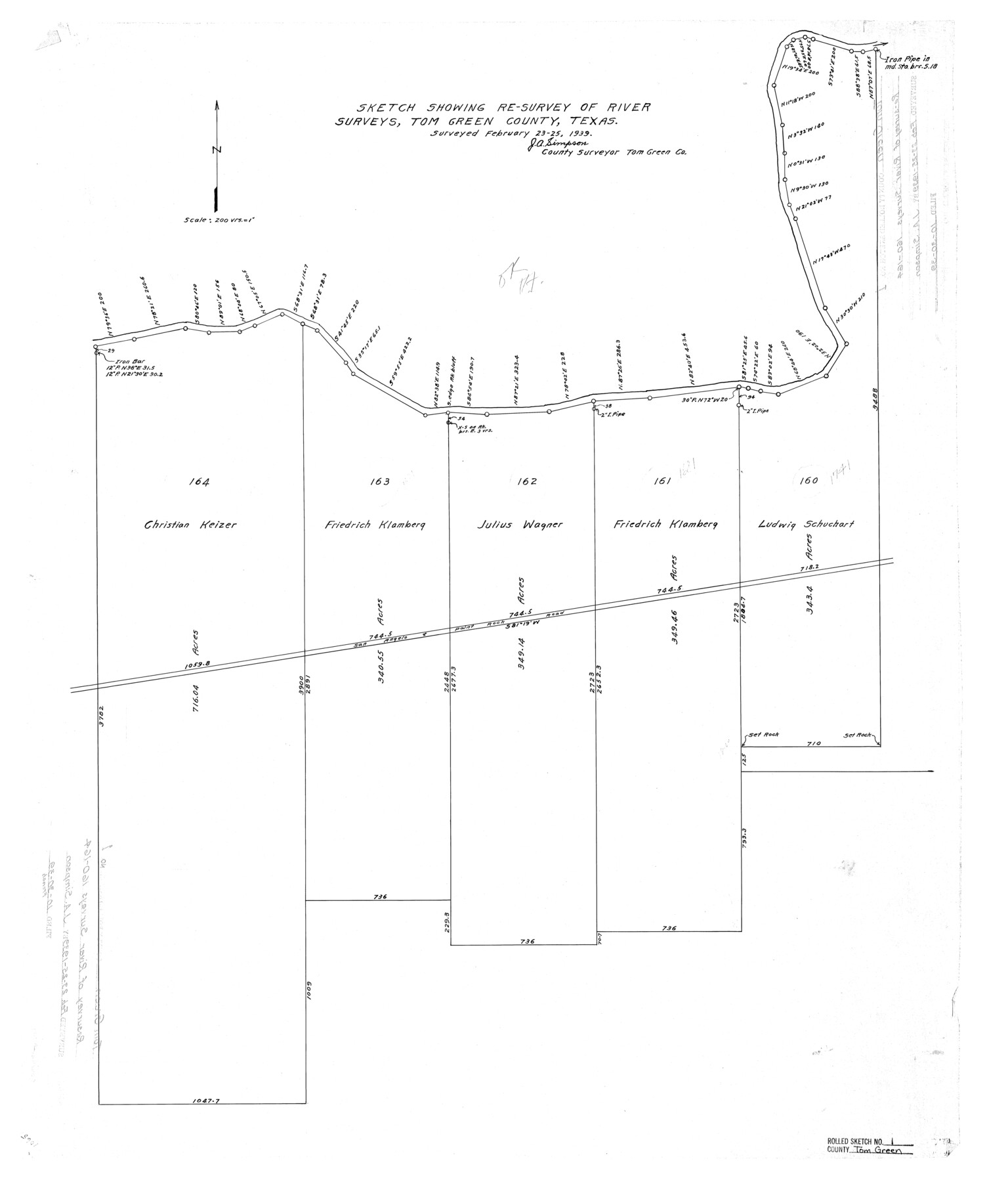
Sketch showing re-survey of river surveys, Tom Green County, Texas
-
Map/Doc
7991
-
Collection
General Map Collection
-
Object Dates
1939/2/25 (Survey Date)
1939/10/30 (File Date)
-
People and Organizations
J.A. Simpson (Surveyor/Engineer)
-
Counties
Tom Green
-
Subjects
Surveying Rolled Sketch
-
Height x Width
29.8 x 25.4 inches
75.7 x 64.5 cm
-
Scale
1" = 200 varas
Part of: General Map Collection
La Salle County Sketch File 22

Print $4.00
- Digital $50.00
La Salle County Sketch File 22
1875
Size 12.8 x 8.2 inches
Map/Doc 29528
Index for Texas Railroad ROW & track maps available on microfilm at THD & Archives and Records

Print $2.00
- Digital $50.00
Index for Texas Railroad ROW & track maps available on microfilm at THD & Archives and Records
1977
Size 11.2 x 8.8 inches
Map/Doc 60756
Bexar County Sketch File 25

Print $4.00
- Digital $50.00
Bexar County Sketch File 25
1860
Size 8.9 x 8.7 inches
Map/Doc 14486
Wharton County Working Sketch 7

Print $20.00
- Digital $50.00
Wharton County Working Sketch 7
1989
Size 27.7 x 24.9 inches
Map/Doc 72471
Flight Mission No. CRC-4R, Frame 152, Chambers County

Print $20.00
- Digital $50.00
Flight Mission No. CRC-4R, Frame 152, Chambers County
1956
Size 18.8 x 22.4 inches
Map/Doc 84915
Flight Mission No. DIX-7P, Frame 90, Aransas County

Print $20.00
- Digital $50.00
Flight Mission No. DIX-7P, Frame 90, Aransas County
1956
Size 18.8 x 22.4 inches
Map/Doc 83884
Flight Mission No. DQN-2K, Frame 65, Calhoun County

Print $20.00
- Digital $50.00
Flight Mission No. DQN-2K, Frame 65, Calhoun County
1953
Size 18.5 x 22.2 inches
Map/Doc 84257
Edwards County Sketch File 43

Print $20.00
- Digital $50.00
Edwards County Sketch File 43
1947
Size 17.4 x 18.2 inches
Map/Doc 11441
Maps of Gulf Intracoastal Waterway, Texas - Sabine River to the Rio Grande and connecting waterways including ship channels

Print $20.00
- Digital $50.00
Maps of Gulf Intracoastal Waterway, Texas - Sabine River to the Rio Grande and connecting waterways including ship channels
1966
Size 14.5 x 22.3 inches
Map/Doc 61977
San Jacinto County Working Sketch 20

Print $20.00
- Digital $50.00
San Jacinto County Working Sketch 20
1939
Size 30.3 x 24.0 inches
Map/Doc 63733
Harris County Rolled Sketch ACS

Print $40.00
- Digital $50.00
Harris County Rolled Sketch ACS
1933
Size 32.7 x 52.8 inches
Map/Doc 8343

You may also like
Flight Mission No. BQY-4M, Frame 62, Harris County

Print $20.00
- Digital $50.00
Flight Mission No. BQY-4M, Frame 62, Harris County
1953
Size 18.7 x 22.5 inches
Map/Doc 85271
Flight Mission No. BQR-13K, Frame 25, Brazoria County

Print $20.00
- Digital $50.00
Flight Mission No. BQR-13K, Frame 25, Brazoria County
1952
Size 18.8 x 22.4 inches
Map/Doc 84073
Flight Mission No. BQR-14K, Frame 37, Brazoria County

Print $20.00
- Digital $50.00
Flight Mission No. BQR-14K, Frame 37, Brazoria County
1952
Size 18.6 x 22.2 inches
Map/Doc 84094
Galveston County NRC Article 33.136 Sketch 22

Print $24.00
- Digital $50.00
Galveston County NRC Article 33.136 Sketch 22
2003
Size 24.2 x 36.0 inches
Map/Doc 78661
Aransas County NRC Article 33.136 Sketch 16

Print $24.00
- Digital $50.00
Aransas County NRC Article 33.136 Sketch 16
Size 24.0 x 36.0 inches
Map/Doc 95381
[Block W, A4, & Part of CL, East Line Sabine County School Land]
![90699, [Block W, A4, & Part of CL, East Line Sabine County School Land], Twichell Survey Records](https://historictexasmaps.com/wmedia_w700/maps/90699-1.tif.jpg)
Print $20.00
- Digital $50.00
[Block W, A4, & Part of CL, East Line Sabine County School Land]
Size 27.5 x 16.6 inches
Map/Doc 90699
Hamilton County Rolled Sketch 14

Print $20.00
- Digital $50.00
Hamilton County Rolled Sketch 14
1989
Size 28.0 x 40.0 inches
Map/Doc 6063
Navigation Maps of Gulf Intracoastal Waterway, Port Arthur to Brownsville, Texas

Print $4.00
- Digital $50.00
Navigation Maps of Gulf Intracoastal Waterway, Port Arthur to Brownsville, Texas
1951
Size 16.5 x 21.1 inches
Map/Doc 65435
[Part of Connected map of Stephen F. Austin's Colony on file at the GLO]
![90119, [Part of Connected map of Stephen F. Austin's Colony on file at the GLO], Twichell Survey Records](https://historictexasmaps.com/wmedia_w700/maps/90119-1.tif.jpg)
Print $20.00
- Digital $50.00
[Part of Connected map of Stephen F. Austin's Colony on file at the GLO]
1923
Size 18.5 x 18.1 inches
Map/Doc 90119

Swisher County Sketch File 2b

Print $4.00
- Digital $50.00
Swisher County Sketch File 2b
1910
Size 11.2 x 8.7 inches
Map/Doc 37616
Green & Lumsden's Ranch

Print $20.00
- Digital $50.00
Green & Lumsden's Ranch
Size 28.4 x 24.7 inches
Map/Doc 92431