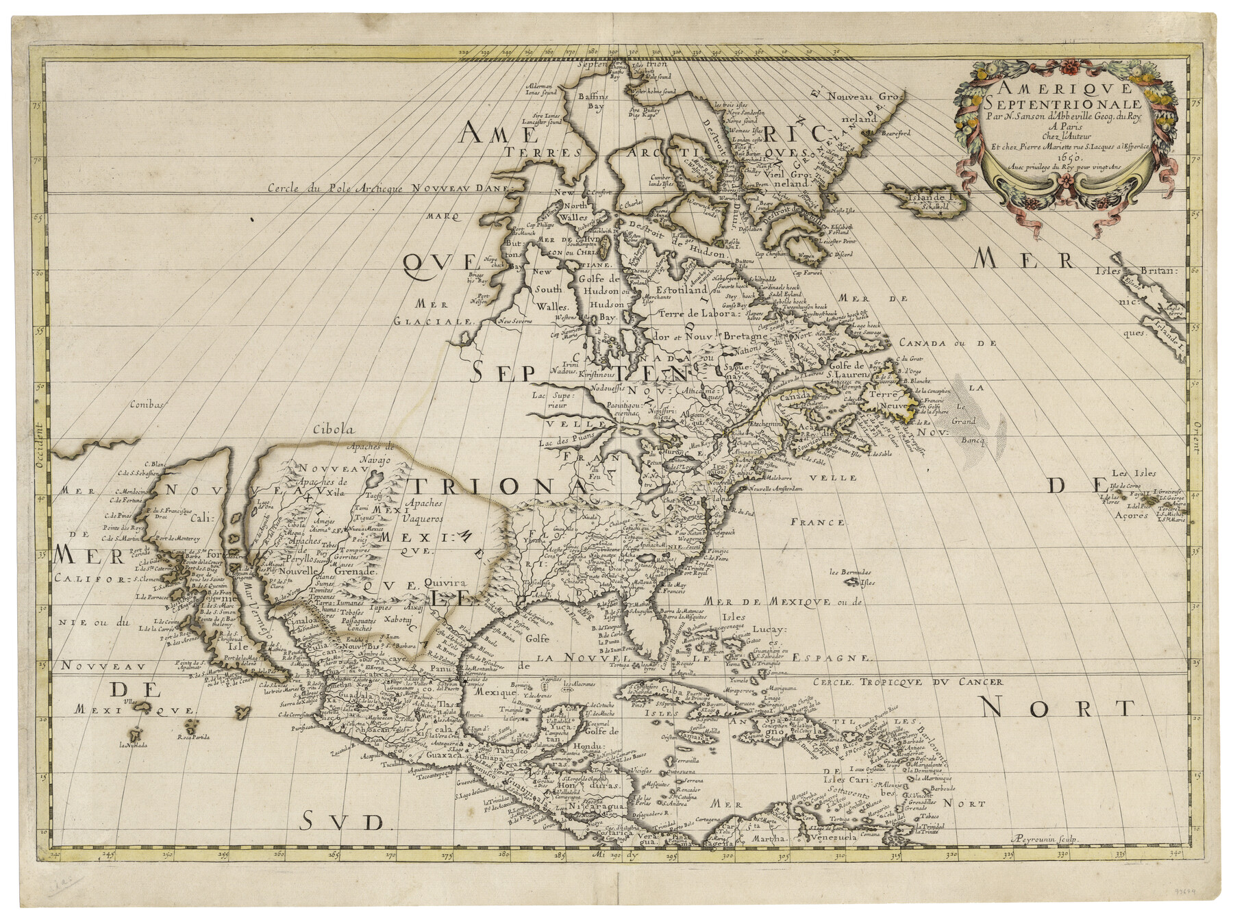
Amerique Septentrionale
-
Map/Doc
93684
-
Collection
General Map Collection
-
Object Dates
1650 (Creation Date)
2014/5/6 (File Date)
-
People and Organizations
Nicholas Sanson (Draftsman)
Nicholas Sanson (Author)
-
Subjects
North America
-
Height x Width
17.2 x 23.1 inches
43.7 x 58.7 cm
-
URLs
https://medium.com/save-texas-history/amerique-septentrionale-north-america-1650-b14abd93509#.5kjpkn123
Part of: General Map Collection
Yoakum County Sketch File 3

Print $54.00
- Digital $50.00
Yoakum County Sketch File 3
1892
Size 14.2 x 8.8 inches
Map/Doc 40705
Brazoria County Working Sketch 17

Print $20.00
- Digital $50.00
Brazoria County Working Sketch 17
1948
Size 17.0 x 19.0 inches
Map/Doc 67502
Coast Chart No. 105 - Galveston Bay to Oyster Bay, Texas

Print $20.00
- Digital $50.00
Coast Chart No. 105 - Galveston Bay to Oyster Bay, Texas
1884
Size 24.3 x 30.1 inches
Map/Doc 69925
Dickens County Working Sketch 13

Print $20.00
- Digital $50.00
Dickens County Working Sketch 13
1981
Size 26.8 x 21.4 inches
Map/Doc 68661

Flight Mission No. CRC-5R, Frame 22, Chambers County

Print $20.00
- Digital $50.00
Flight Mission No. CRC-5R, Frame 22, Chambers County
1956
Size 18.7 x 22.6 inches
Map/Doc 84944
Cameron County Rolled Sketch 29

Print $20.00
- Digital $50.00
Cameron County Rolled Sketch 29
1990
Size 29.3 x 46.4 inches
Map/Doc 8578
Upton County Rolled Sketch 10

Print $20.00
- Digital $50.00
Upton County Rolled Sketch 10
1911
Size 41.2 x 43.0 inches
Map/Doc 10035
Hardin County Working Sketch 9

Print $20.00
- Digital $50.00
Hardin County Working Sketch 9
1928
Size 21.7 x 21.1 inches
Map/Doc 63407
Liberty County Working Sketch 3

Print $20.00
- Digital $50.00
Liberty County Working Sketch 3
1891
Size 16.2 x 13.2 inches
Map/Doc 70462
Flight Mission No. DQN-7K, Frame 3, Calhoun County

Print $20.00
- Digital $50.00
Flight Mission No. DQN-7K, Frame 3, Calhoun County
1953
Size 18.5 x 22.2 inches
Map/Doc 84454
Hays County Sketch File 33

Print $40.00
- Digital $50.00
Hays County Sketch File 33
1944
Size 16.4 x 15.1 inches
Map/Doc 26268
You may also like

Real County Working Sketch 27

Print $20.00
- Digital $50.00
Real County Working Sketch 27
1947
Size 29.8 x 29.2 inches
Map/Doc 71919
Leon County Rolled Sketch 34

Print $20.00
- Digital $50.00
Leon County Rolled Sketch 34
1999
Size 31.8 x 37.1 inches
Map/Doc 87502

Webb County Working Sketch 20

Print $20.00
- Digital $50.00
Webb County Working Sketch 20
1925
Size 22.3 x 20.2 inches
Map/Doc 72385
Hall County Working Sketch Graphic Index

Print $20.00
- Digital $50.00
Hall County Working Sketch Graphic Index
1972
Size 41.7 x 33.7 inches
Map/Doc 76563
Travis County Sketch File 10

Print $16.00
- Digital $50.00
Travis County Sketch File 10
1863
Size 7.7 x 13.7 inches
Map/Doc 38292
Dallas County Boundary File 6f

Print $8.00
- Digital $50.00
Dallas County Boundary File 6f
Size 13.9 x 8.6 inches
Map/Doc 52271

McMullen County Working Sketch 29

Print $40.00
- Digital $50.00
McMullen County Working Sketch 29
1956
Size 59.0 x 37.2 inches
Map/Doc 70730
Sketch of a portion of the Texas Coast showing the relative positions of different harbours with the interior Military Posts, and the roads communicating with them, also two new routes from Black Point and Lamar to San Antonio

Print $20.00
- Digital $50.00
Sketch of a portion of the Texas Coast showing the relative positions of different harbours with the interior Military Posts, and the roads communicating with them, also two new routes from Black Point and Lamar to San Antonio
1855
Size 27.2 x 18.3 inches
Map/Doc 72711
[Surveys along the Texas coast across from Mustang Island]
![346, [Surveys along the Texas coast across from Mustang Island], General Map Collection](https://historictexasmaps.com/wmedia_w700/maps/346.tif.jpg)
Print $2.00
- Digital $50.00
[Surveys along the Texas coast across from Mustang Island]
1841
Size 11.3 x 7.3 inches
Map/Doc 346