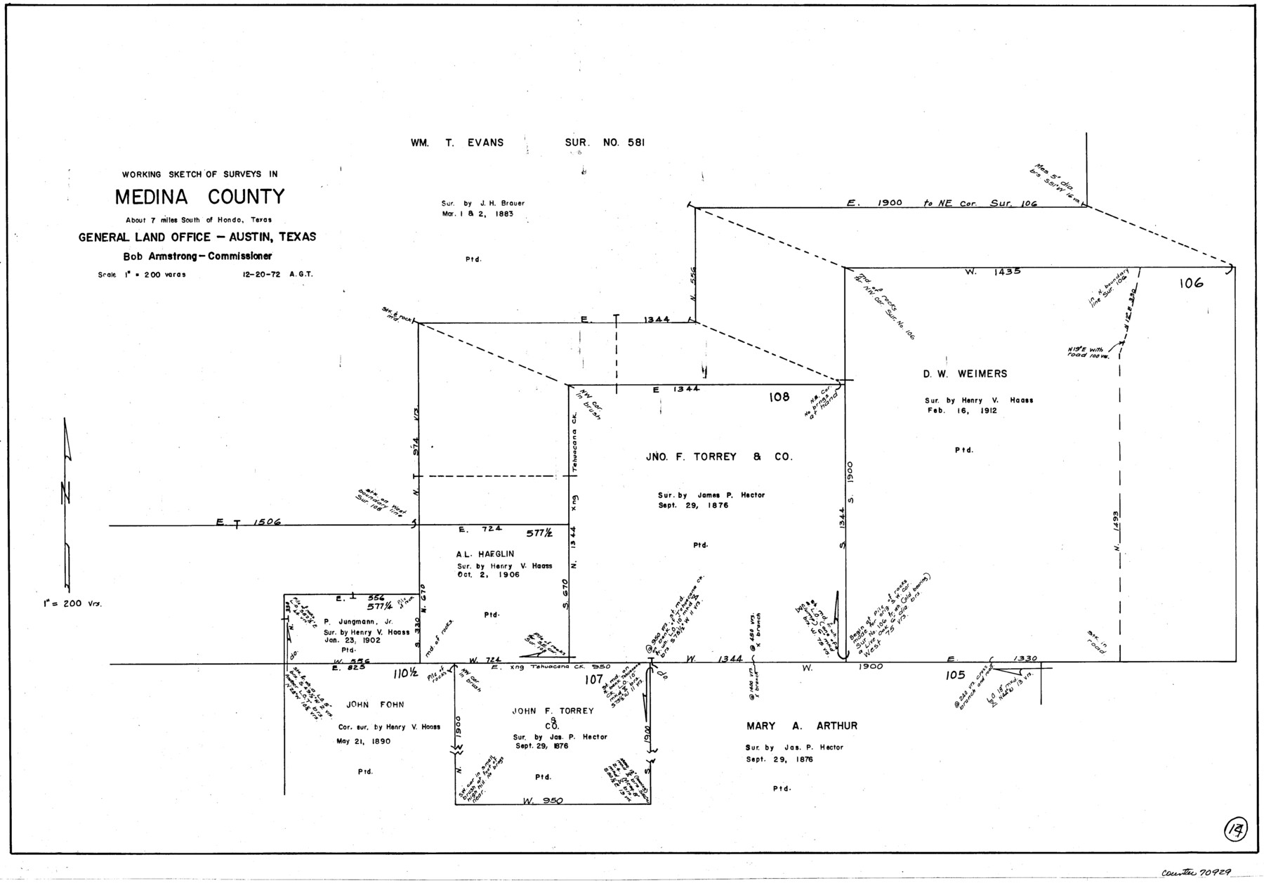
Medina County Working Sketch 14
-
Map/Doc
70929
-
Collection
General Map Collection
-
Object Dates
12/20/1972 (Creation Date)
-
People and Organizations
Abner G. Trigg (Draftsman)
-
Counties
Medina
-
Subjects
Surveying Working Sketch
-
Height x Width
21.5 x 30.7 inches
54.6 x 78.0 cm
-
Scale
1" = 200 varas
Part of: General Map Collection
Parker County Sketch File 22

Print $4.00
- Digital $50.00
Parker County Sketch File 22
Size 8.7 x 6.3 inches
Map/Doc 33562
Outline Map showing a New Route from Texas to Fort Yuma, California for Cattle Droves and Trains En route to California

Print $40.00
- Digital $50.00
Outline Map showing a New Route from Texas to Fort Yuma, California for Cattle Droves and Trains En route to California
1880
Size 17.5 x 52.2 inches
Map/Doc 97141
Coast Chart No. 210 - Aransas Pass and Corpus Christi Bay with the coast to latitude 27° 12', Texas

Print $20.00
- Digital $50.00
Coast Chart No. 210 - Aransas Pass and Corpus Christi Bay with the coast to latitude 27° 12', Texas
1913
Size 18.1 x 23.4 inches
Map/Doc 73455
Falls County Sketch File 16a

Print $20.00
- Digital $50.00
Falls County Sketch File 16a
1871
Size 30.6 x 21.0 inches
Map/Doc 11466
Cochran County Rolled Sketch 4

Print $20.00
- Digital $50.00
Cochran County Rolled Sketch 4
1945
Size 16.8 x 23.7 inches
Map/Doc 5501
Flight Mission No. DAG-22K, Frame 74, Matagorda County

Print $20.00
- Digital $50.00
Flight Mission No. DAG-22K, Frame 74, Matagorda County
1953
Size 18.8 x 22.5 inches
Map/Doc 86461
Jeff Davis County Working Sketch 37

Print $20.00
- Digital $50.00
Jeff Davis County Working Sketch 37
1979
Size 31.6 x 36.6 inches
Map/Doc 66532
Jasper County Working Sketch 4

Print $20.00
- Digital $50.00
Jasper County Working Sketch 4
1905
Size 20.3 x 13.5 inches
Map/Doc 66466
Sterling County Rolled Sketch 8

Print $20.00
- Digital $50.00
Sterling County Rolled Sketch 8
1884
Size 27.9 x 31.9 inches
Map/Doc 7844
Matagorda County

Print $40.00
- Digital $50.00
Matagorda County
1920
Size 39.7 x 49.1 inches
Map/Doc 77368
Dawson County Rolled Sketch 7
Print $20.00
- Digital $50.00
Dawson County Rolled Sketch 7
Size 14.1 x 38.1 inches
Map/Doc 5693
Jefferson County Sketch File 26a

Print $20.00
- Digital $50.00
Jefferson County Sketch File 26a
Size 19.5 x 11.6 inches
Map/Doc 11872
You may also like
[Sketch showing surveys in the south half of Potter County, Blocks 6, 20-E, JAD, M-3, S, B. S. & F. Blocks 1 and 9, and A. B. and M. Block 2]
![91741, [Sketch showing surveys in the south half of Potter County, Blocks 6, 20-E, JAD, M-3, S, B. S. & F. Blocks 1 and 9, and A. B. and M. Block 2], Twichell Survey Records](https://historictexasmaps.com/wmedia_w700/maps/91741-1.tif.jpg)
Print $20.00
- Digital $50.00
[Sketch showing surveys in the south half of Potter County, Blocks 6, 20-E, JAD, M-3, S, B. S. & F. Blocks 1 and 9, and A. B. and M. Block 2]
Size 40.5 x 18.1 inches
Map/Doc 91741
Clay County Boundary File 14

Print $80.00
- Digital $50.00
Clay County Boundary File 14
Size 63.1 x 15.4 inches
Map/Doc 51416
General Highway Map, Johnson County, Texas

Print $20.00
General Highway Map, Johnson County, Texas
1940
Size 18.3 x 24.8 inches
Map/Doc 79149

Flight Mission No. CZW-1R, Frame 165, Hardeman County

Print $20.00
- Digital $50.00
Flight Mission No. CZW-1R, Frame 165, Hardeman County
1956
Size 18.7 x 22.4 inches
Map/Doc 85236
Pecos County Working Sketch 10

Print $20.00
- Digital $50.00
Pecos County Working Sketch 10
1907
Size 25.9 x 23.9 inches
Map/Doc 71480
Map of Kaufman County

Print $20.00
- Digital $50.00
Map of Kaufman County
1867
Size 27.4 x 22.2 inches
Map/Doc 3749
Hardin County Working Sketch 40

Print $20.00
- Digital $50.00
Hardin County Working Sketch 40
1988
Size 23.0 x 14.4 inches
Map/Doc 63439
[Map of Line Dividing Fannin and Nacogdoches Districts]
![1707, [Map of Line Dividing Fannin and Nacogdoches Districts], General Map Collection](https://historictexasmaps.com/wmedia_w700/maps/1707-1.tif.jpg)
Print $20.00
- Digital $50.00
[Map of Line Dividing Fannin and Nacogdoches Districts]
1850
Size 34.2 x 39.0 inches
Map/Doc 1707
Hardin County Sketch File 67

Print $10.00
- Digital $50.00
Hardin County Sketch File 67
Size 11.4 x 8.9 inches
Map/Doc 25252
Flight Mission No. DAG-23K, Frame 169, Matagorda County

Print $20.00
- Digital $50.00
Flight Mission No. DAG-23K, Frame 169, Matagorda County
1953
Size 16.0 x 15.8 inches
Map/Doc 86507
Donley County Sketch File B6

Print $20.00
- Digital $50.00
Donley County Sketch File B6
1919
Size 16.5 x 14.6 inches
Map/Doc 11376