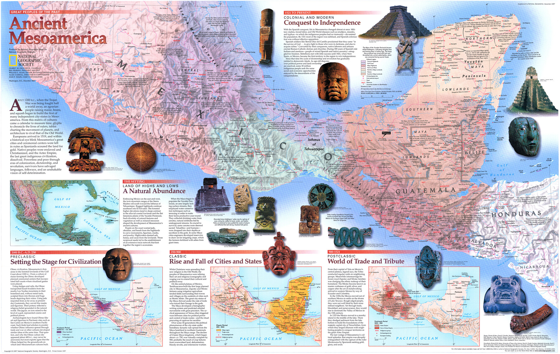
Ancient Mesoamerica
-
Map/Doc
95926
-
Collection
General Map Collection
-
Object Dates
1997 (Publication Date)
-
People and Organizations
National Geographic Society (Publisher)
Mark Lambert (Donor)
-
Subjects
Central America Mexico Pictorial
-
Height x Width
22.2 x 35.1 inches
56.4 x 89.2 cm
-
Medium
paper, print
-
Comments
For research only. Donated by Mark Lambert in August, 2020. See 95925 for recto.
Related maps

Part of: General Map Collection
Houston County Working Sketch 24

Print $40.00
- Digital $50.00
Houston County Working Sketch 24
1983
Size 43.9 x 77.2 inches
Map/Doc 66254
Parker County Sketch File 36

Print $7.00
- Digital $50.00
Parker County Sketch File 36
Size 9.1 x 7.8 inches
Map/Doc 33578
Van Zandt County Sketch File 38

Print $4.00
- Digital $50.00
Van Zandt County Sketch File 38
1871
Size 8.2 x 10.1 inches
Map/Doc 39482
Flight Mission No. DIX-6P, Frame 119, Aransas County

Print $20.00
- Digital $50.00
Flight Mission No. DIX-6P, Frame 119, Aransas County
1956
Size 19.1 x 22.7 inches
Map/Doc 83825
Montague County Working Sketch 21

Print $20.00
- Digital $50.00
Montague County Working Sketch 21
1952
Size 33.1 x 39.5 inches
Map/Doc 71087
Marion County Boundary File 2

Print $6.00
- Digital $50.00
Marion County Boundary File 2
Size 11.2 x 8.7 inches
Map/Doc 56818
Culberson County Rolled Sketch 58

Print $40.00
- Digital $50.00
Culberson County Rolled Sketch 58
1979
Size 37.8 x 52.6 inches
Map/Doc 8759
Val Verde County Working Sketch 99

Print $20.00
- Digital $50.00
Val Verde County Working Sketch 99
1981
Size 17.2 x 22.6 inches
Map/Doc 72234
[Surveys in Austin's Colony along the east side of the Brazos River]
![191, [Surveys in Austin's Colony along the east side of the Brazos River], General Map Collection](https://historictexasmaps.com/wmedia_w700/maps/191-1.tif.jpg)
Print $20.00
- Digital $50.00
[Surveys in Austin's Colony along the east side of the Brazos River]
1824
Size 26.7 x 8.4 inches
Map/Doc 191
Map of Comanche Co.

Print $20.00
- Digital $50.00
Map of Comanche Co.
1896
Size 39.3 x 43.1 inches
Map/Doc 66782
Armstrong County Rolled Sketch ACP

Print $20.00
- Digital $50.00
Armstrong County Rolled Sketch ACP
1900
Size 33.0 x 35.3 inches
Map/Doc 8425
Duval County Sketch File 35b

Print $6.00
- Digital $50.00
Duval County Sketch File 35b
1935
Size 14.4 x 8.8 inches
Map/Doc 21374
You may also like
Clay County Boundary File 19

Print $8.00
- Digital $50.00
Clay County Boundary File 19
1924
Size 3.3 x 5.5 inches
Map/Doc 65511
McMullen County Working Sketch 51

Print $20.00
- Digital $50.00
McMullen County Working Sketch 51
1983
Size 18.3 x 17.4 inches
Map/Doc 70752
Map Showing Location of Dallas & Greenville Railway through Hunt County, Texas

Print $2.00
- Digital $50.00
Map Showing Location of Dallas & Greenville Railway through Hunt County, Texas
Size 11.9 x 8.2 inches
Map/Doc 64486
Map of Mexico, Texas, Old and New California, and Yucatan

Print $20.00
Map of Mexico, Texas, Old and New California, and Yucatan
1847
Size 17.9 x 24.4 inches
Map/Doc 76191
General Chart of the Coast No. XXI Gulf Coast from Galveston to the Rio Grande

Print $20.00
- Digital $50.00
General Chart of the Coast No. XXI Gulf Coast from Galveston to the Rio Grande
1883
Size 27.2 x 18.3 inches
Map/Doc 72728
Zavala County Working Sketch 18

Print $20.00
- Digital $50.00
Zavala County Working Sketch 18
1977
Size 43.8 x 42.1 inches
Map/Doc 62093
K&E Paragon N4238 Compensating Polar Planimeter

K&E Paragon N4238 Compensating Polar Planimeter
1930
Size 1.5 x 9.3 inches
Map/Doc 97308
Packery Channel

Print $20.00
- Digital $50.00
Packery Channel
1975
Size 18.6 x 46.2 inches
Map/Doc 3004

Dimmit County Sketch File 49

Print $20.00
- Digital $50.00
Dimmit County Sketch File 49
1909
Size 17.3 x 26.8 inches
Map/Doc 11358
Hardeman County Sketch File 15

Print $20.00
- Digital $50.00
Hardeman County Sketch File 15
Size 18.9 x 17.9 inches
Map/Doc 11627
[Surveys in the vicinity of Archer County School Land]
![90325, [Surveys in the vicinity of Archer County School Land], Twichell Survey Records](https://historictexasmaps.com/wmedia_w700/maps/90325-1.tif.jpg)
Print $20.00
- Digital $50.00
[Surveys in the vicinity of Archer County School Land]
Size 15.1 x 20.6 inches
Map/Doc 90325