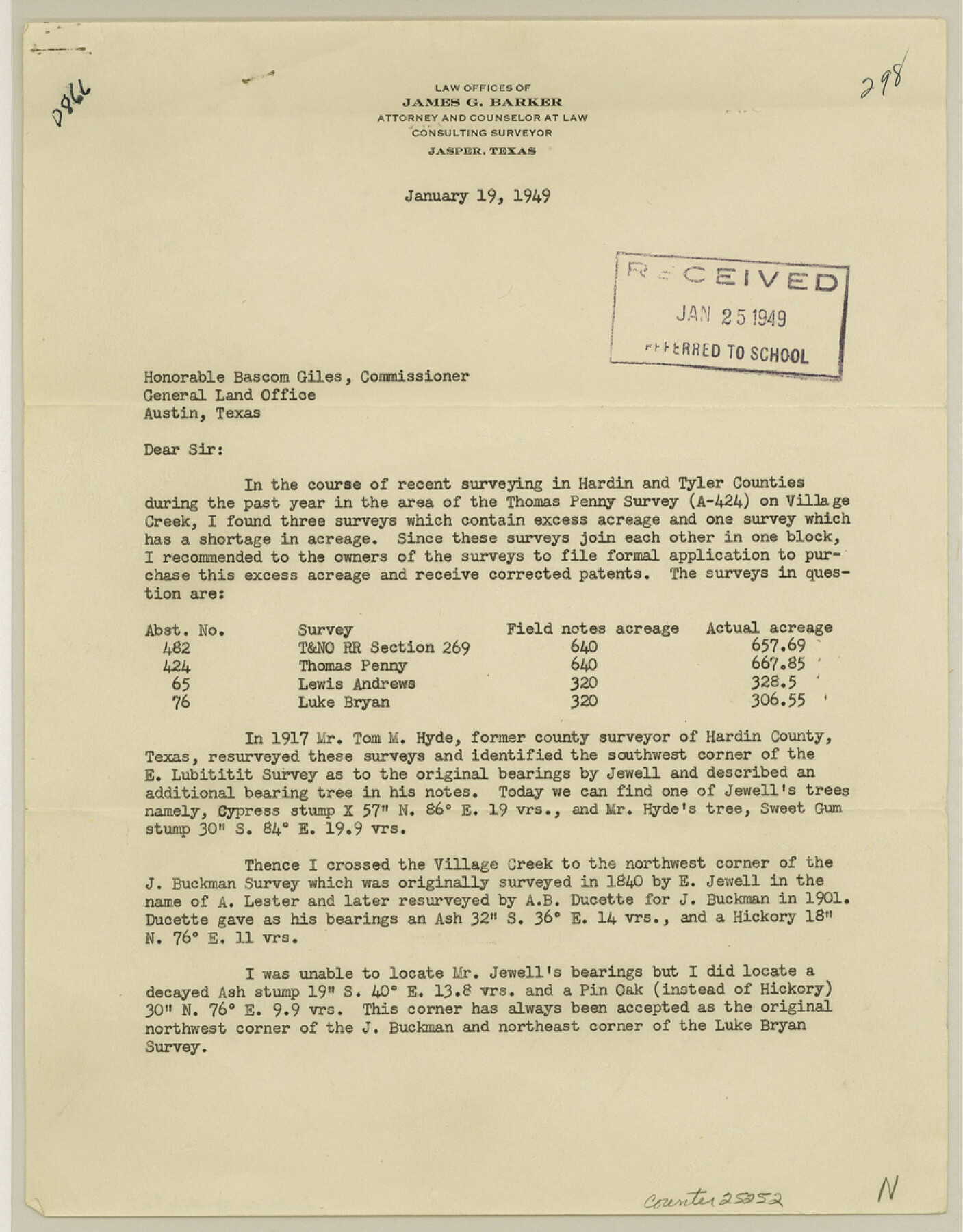
Hardin County Sketch File 67
[Report of Thomas Penny area]
-
Map/Doc
25252
-
Collection
General Map Collection
-
Object Dates
1949/1/19 (Correspondence Date)
1917 (Survey Date)
1949/2/5 (File Date)
-
People and Organizations
Tom M. Hyde (Surveyor/Engineer)
Jas. G. Barker (Surveyor/Engineer)
-
Counties
Hardin
-
Subjects
Surveying Sketch File
-
Height x Width
11.4 x 8.9 inches
29.0 x 22.6 cm
-
Medium
paper, print
-
Comments
See Hardin County Rolled Sketch 10 (6082) for sketch.
-
Features
Village Creek
Related maps
Hardin County Rolled Sketch 10

Print $20.00
- Digital $50.00
Hardin County Rolled Sketch 10
1948
Size 23.7 x 33.0 inches
Map/Doc 6082
Part of: General Map Collection
Aransas County Sketch File 35

Print $61.00
- Digital $50.00
Aransas County Sketch File 35
1984
Size 11.0 x 8.8 inches
Map/Doc 13347
Duval County Sketch File 72

Print $6.00
- Digital $50.00
Duval County Sketch File 72
Size 10.4 x 8.6 inches
Map/Doc 21460
King County Sketch File 9

Print $20.00
- Digital $50.00
King County Sketch File 9
Size 23.5 x 33.0 inches
Map/Doc 11937
Medina County Rolled Sketch 10

Print $20.00
- Digital $50.00
Medina County Rolled Sketch 10
1977
Size 14.3 x 21.7 inches
Map/Doc 6744
Gonzales County Sketch File 2

Print $10.00
- Digital $50.00
Gonzales County Sketch File 2
Size 8.9 x 7.8 inches
Map/Doc 24357
Crockett County Working Sketch 100

Print $20.00
- Digital $50.00
Crockett County Working Sketch 100
1980
Size 35.6 x 39.9 inches
Map/Doc 68433
Floyd County Rolled Sketch 7

Print $3.00
- Digital $50.00
Floyd County Rolled Sketch 7
Size 8.7 x 13.9 inches
Map/Doc 5881
Nueces County Rolled Sketch 123

Print $20.00
- Digital $50.00
Nueces County Rolled Sketch 123
1997
Size 18.2 x 24.9 inches
Map/Doc 7158
Red River County Sketch File 5

Print $4.00
- Digital $50.00
Red River County Sketch File 5
Size 7.9 x 4.8 inches
Map/Doc 35102
Blocks No. 8, 9 & 10 Houston & Great Northern Rail Road Company Surveys in Pecos County, Texas

Print $20.00
- Digital $50.00
Blocks No. 8, 9 & 10 Houston & Great Northern Rail Road Company Surveys in Pecos County, Texas
1891
Size 24.5 x 38.7 inches
Map/Doc 3955
Winkler County Working Sketch 6

Print $20.00
- Digital $50.00
Winkler County Working Sketch 6
1957
Size 34.5 x 31.5 inches
Map/Doc 72600
Newton County Working Sketch 25

Print $20.00
- Digital $50.00
Newton County Working Sketch 25
1953
Size 25.4 x 23.8 inches
Map/Doc 71271
You may also like
Andrews County Rolled Sketch 41

Print $20.00
- Digital $50.00
Andrews County Rolled Sketch 41
Size 18.0 x 24.0 inches
Map/Doc 77181
Lipscomb County Boundary File 5

Print $4.00
- Digital $50.00
Lipscomb County Boundary File 5
Size 5.5 x 8.6 inches
Map/Doc 56327
Map of Houston County

Print $40.00
- Digital $50.00
Map of Houston County
1841
Size 58.6 x 32.2 inches
Map/Doc 1952
Davis Mountains State Park Area Showing Scenic Drive

Print $20.00
Davis Mountains State Park Area Showing Scenic Drive
1935
Size 26.9 x 34.5 inches
Map/Doc 76312
Cliffside Situated on Section 21, Block 9, Potter County, Texas

Print $2.00
- Digital $50.00
Cliffside Situated on Section 21, Block 9, Potter County, Texas
Size 6.1 x 11.5 inches
Map/Doc 92100
Uvalde County Working Sketch 10

Print $20.00
- Digital $50.00
Uvalde County Working Sketch 10
1943
Size 30.3 x 38.7 inches
Map/Doc 72080
Subdivision of Alexander Ranch, Cochran County, Texas

Print $20.00
- Digital $50.00
Subdivision of Alexander Ranch, Cochran County, Texas
Size 15.4 x 29.8 inches
Map/Doc 92496
Fractional Township No. 9 South Range No. 11 East of the Indian Meridian, Indian Territory

Print $20.00
- Digital $50.00
Fractional Township No. 9 South Range No. 11 East of the Indian Meridian, Indian Territory
1898
Size 19.3 x 24.4 inches
Map/Doc 75220
Hill County Sketch File 21

Print $4.00
- Digital $50.00
Hill County Sketch File 21
1856
Size 11.1 x 8.8 inches
Map/Doc 26501
[Map of Connecting Lines along or near the Red River]
![75546, [Map of Connecting Lines along or near the Red River], General Map Collection](https://historictexasmaps.com/wmedia_w700/maps/75546.tif.jpg)
Print $20.00
- Digital $50.00
[Map of Connecting Lines along or near the Red River]
Size 28.6 x 37.0 inches
Map/Doc 75546
Loving County Working Sketch 12

Print $40.00
- Digital $50.00
Loving County Working Sketch 12
1957
Size 48.1 x 37.1 inches
Map/Doc 70645
