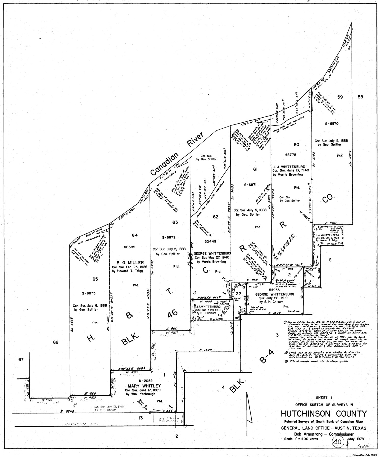
Hutchinson County Working Sketch 40
-
Map/Doc
66400
-
Collection
General Map Collection
-
Object Dates
5/1978 (Creation Date)
-
Counties
Hutchinson
-
Subjects
Surveying Working Sketch
-
Height x Width
27.0 x 22.4 inches
68.6 x 56.9 cm
-
Scale
1" = 400 varas
Part of: General Map Collection
Crockett County Rolled Sketch 98

Print $40.00
- Digital $50.00
Crockett County Rolled Sketch 98
2021
Size 36.5 x 48.3 inches
Map/Doc 96577
Crane County Working Sketch 8

Print $20.00
- Digital $50.00
Crane County Working Sketch 8
1929
Size 33.2 x 28.4 inches
Map/Doc 68285
Panola County Working Sketch 16

Print $20.00
- Digital $50.00
Panola County Working Sketch 16
1945
Map/Doc 71425
Runnels County Working Sketch 18

Print $20.00
- Digital $50.00
Runnels County Working Sketch 18
1950
Size 27.9 x 31.2 inches
Map/Doc 63614
Wheeler County Working Sketch 4

Print $40.00
- Digital $50.00
Wheeler County Working Sketch 4
1972
Size 58.9 x 47.1 inches
Map/Doc 72493
Section IX, Galveston Harbor and Bar

Print $20.00
- Digital $50.00
Section IX, Galveston Harbor and Bar
1850
Size 30.0 x 45.7 inches
Map/Doc 69855
Glasscock County Working Sketch 8

Print $40.00
- Digital $50.00
Glasscock County Working Sketch 8
1955
Size 43.5 x 120.3 inches
Map/Doc 63181
Eastland County Working Sketch 28

Print $20.00
- Digital $50.00
Eastland County Working Sketch 28
1952
Size 25.0 x 21.3 inches
Map/Doc 68809
Randall County Sketch File 7

Print $14.00
- Digital $50.00
Randall County Sketch File 7
1931
Size 7.3 x 8.9 inches
Map/Doc 34963
Brown County Sketch File 26

Print $40.00
- Digital $50.00
Brown County Sketch File 26
Size 18.4 x 24.4 inches
Map/Doc 11023
Henderson County

Print $20.00
- Digital $50.00
Henderson County
1856
Size 17.9 x 29.2 inches
Map/Doc 3664
Revised Map of the State of Texas

Print $20.00
- Digital $50.00
Revised Map of the State of Texas
1876
Size 20.6 x 20.6 inches
Map/Doc 96795
You may also like

Motley County Sketch File B3 (N)

Print $10.00
- Digital $50.00
Motley County Sketch File B3 (N)
1900
Size 6.5 x 11.9 inches
Map/Doc 31974
A. R. Roessler's Latest Map of the State of Texas Exhibiting Mineral and Agricultural Districts, Post Offices and Mailroutes, Railroads projected and finished, Timber, Prairie, Swamp Lands, etc. etc. etc.

Print $20.00
- Digital $50.00
A. R. Roessler's Latest Map of the State of Texas Exhibiting Mineral and Agricultural Districts, Post Offices and Mailroutes, Railroads projected and finished, Timber, Prairie, Swamp Lands, etc. etc. etc.
1874
Size 40.8 x 47.4 inches
Map/Doc 93934
Flight Mission No. BQY-1T, Frame 74, Harris County

Print $20.00
- Digital $50.00
Flight Mission No. BQY-1T, Frame 74, Harris County
1957
Size 17.5 x 17.6 inches
Map/Doc 85294
Working Sketch in Bailey County

Print $20.00
- Digital $50.00
Working Sketch in Bailey County
1906
Size 22.2 x 12.5 inches
Map/Doc 90184
[West and North lines of the Panhandle]
![90576, [West and North lines of the Panhandle], Twichell Survey Records](https://historictexasmaps.com/wmedia_w700/maps/90576-1.tif.jpg)
Print $20.00
- Digital $50.00
[West and North lines of the Panhandle]
1885
Size 22.0 x 32.1 inches
Map/Doc 90576
Angelina County Sketch File 28

Print $22.00
- Digital $50.00
Angelina County Sketch File 28
1910
Size 15.7 x 12.0 inches
Map/Doc 13078
Brewster County Working Sketch 61

Print $20.00
- Digital $50.00
Brewster County Working Sketch 61
1955
Size 32.1 x 43.3 inches
Map/Doc 67662
Throckmorton County Rolled Sketch 5A

Print $20.00
- Digital $50.00
Throckmorton County Rolled Sketch 5A
2001
Size 25.2 x 36.0 inches
Map/Doc 76406
Jeff Davis County Rolled Sketch 10

Print $6.00
- Digital $50.00
Jeff Davis County Rolled Sketch 10
1906
Size 29.6 x 30.1 inches
Map/Doc 6363
Anderson County Sketch File 16b

Print $2.00
- Digital $50.00
Anderson County Sketch File 16b
1859
Size 7.2 x 2.9 inches
Map/Doc 12788
Webb County Boundary File 3b

Print $82.00
- Digital $50.00
Webb County Boundary File 3b
Size 20.3 x 50.8 inches
Map/Doc 59758