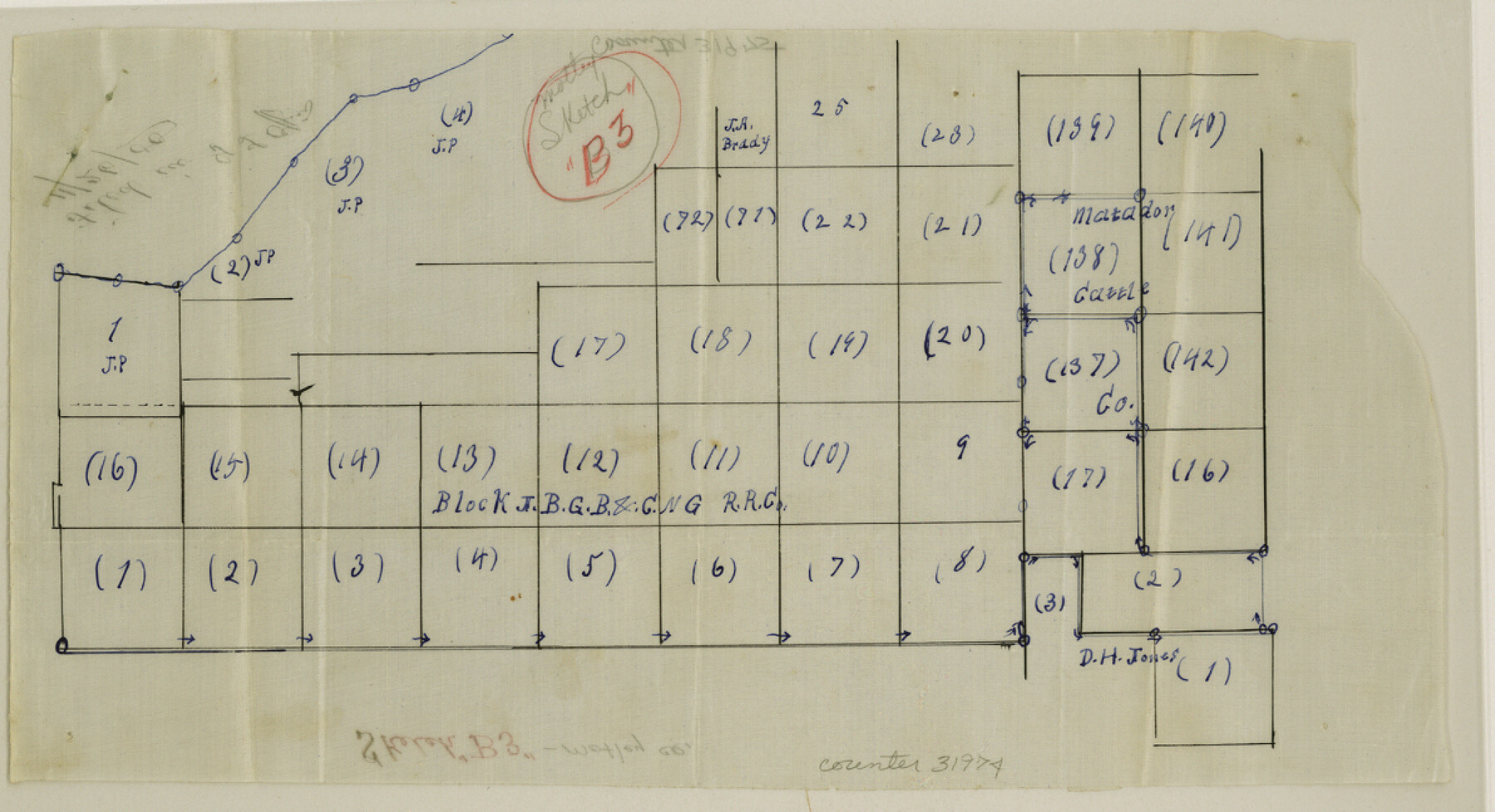
Motley County Sketch File B3 (N)
[Sketch of Block JB, G. B. & C. N. G. RR. Co.]
-
Map/Doc
31974
-
Collection
General Map Collection
-
Object Dates
11/12/1900 (Creation Date)
11/26/1900 (File Date)
5/1/1900 (Survey Date)
11/1/1900 (Survey Date)
6/1900 (Survey Date)
7/1900 (Survey Date)
8/1900 (Survey Date)
9/1900 (Survey Date)
10/1900 (Survey Date)
-
People and Organizations
T.H. Seay (Surveyor/Engineer)
J.C. Riley (Chainman/Field Personnel)
J.A. Bardwell (Chainman/Field Personnel)
Henry Pipkins (Chainman/Field Personnel)
Cliff Rogers (Chainman/Field Personnel)
Frank O'Coner (Chainman/Field Personnel)
-
Counties
Motley
-
Subjects
Surveying Sketch File
-
Height x Width
6.5 x 11.9 inches
16.5 x 30.2 cm
-
Medium
paper, manuscript
-
Features
Turtlehole Mountain
Gypsum Gulch
Part of: General Map Collection
Presidio County Rolled Sketch 114

Print $20.00
- Digital $50.00
Presidio County Rolled Sketch 114
Size 28.2 x 40.3 inches
Map/Doc 7390
Map of the District of San Patricio and Nueces

Print $40.00
- Digital $50.00
Map of the District of San Patricio and Nueces
Size 93.8 x 38.4 inches
Map/Doc 93366
Palo Pinto County Sketch File 6

Print $40.00
- Digital $50.00
Palo Pinto County Sketch File 6
1875
Size 9.3 x 18.8 inches
Map/Doc 33396
Montgomery County Working Sketch 45

Print $20.00
- Digital $50.00
Montgomery County Working Sketch 45
1956
Size 14.8 x 29.5 inches
Map/Doc 71152
Map No. 1 - Rio Bravo del Norte section of boundary between the United States & Mexico agreed upon by the Joint Commission under the Treaty of Guadalupe Hidalgo

Print $20.00
- Digital $50.00
Map No. 1 - Rio Bravo del Norte section of boundary between the United States & Mexico agreed upon by the Joint Commission under the Treaty of Guadalupe Hidalgo
1852
Size 18.3 x 27.0 inches
Map/Doc 72863
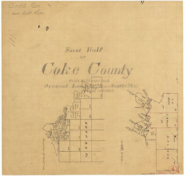
Coke County Working Sketch 4
Print $20.00
- Digital $50.00
Coke County Working Sketch 4
1897
Size 15.6 x 16.4 inches
Map/Doc 68041
Upton County Working Sketch 4

Print $20.00
- Digital $50.00
Upton County Working Sketch 4
Size 21.8 x 33.9 inches
Map/Doc 69500
Comanche County Sketch File 23

Print $4.00
- Digital $50.00
Comanche County Sketch File 23
Size 8.3 x 7.5 inches
Map/Doc 19111
Maps of Gulf Intracoastal Waterway, Texas - Sabine River to the Rio Grande and connecting waterways including ship channels

Print $20.00
- Digital $50.00
Maps of Gulf Intracoastal Waterway, Texas - Sabine River to the Rio Grande and connecting waterways including ship channels
1966
Size 14.6 x 22.2 inches
Map/Doc 61967
Travis County Sketch File 75A

Print $20.00
- Digital $50.00
Travis County Sketch File 75A
1992
Size 37.9 x 28.8 inches
Map/Doc 12478
Mason County Sketch File 5

Print $20.00
- Digital $50.00
Mason County Sketch File 5
1875
Size 15.8 x 12.9 inches
Map/Doc 12033
Anderson County Working Sketch 31

Print $20.00
- Digital $50.00
Anderson County Working Sketch 31
1966
Size 18.3 x 23.2 inches
Map/Doc 67031
You may also like

[John S. Stephens Blk. S2, Lgs. 174-177, 186-193, 201-209]
![89984, [John S. Stephens Blk. S2, Lgs. 174-177, 186-193, 201-209], Twichell Survey Records](https://historictexasmaps.com/wmedia_w700/maps/89984-1.tif.jpg)
Print $2.00
- Digital $50.00
[John S. Stephens Blk. S2, Lgs. 174-177, 186-193, 201-209]
1912
Size 11.4 x 8.8 inches
Map/Doc 89984
Llano County Working Sketch 2

Print $20.00
- Digital $50.00
Llano County Working Sketch 2
1949
Size 21.0 x 24.3 inches
Map/Doc 70620
Duval County Sketch File 58

Print $20.00
- Digital $50.00
Duval County Sketch File 58
1940
Size 18.3 x 19.0 inches
Map/Doc 11406
[Dallam County Map]
![93157, [Dallam County Map], Twichell Survey Records](https://historictexasmaps.com/wmedia_w700/maps/93157-1.tif.jpg)
Print $40.00
- Digital $50.00
[Dallam County Map]
Size 51.1 x 65.2 inches
Map/Doc 93157
Nueces County Sketch File 72

Print $13.00
- Digital $50.00
Nueces County Sketch File 72
1991
Size 11.1 x 8.8 inches
Map/Doc 33020
Pecos County Sketch File 96

Print $40.00
- Digital $50.00
Pecos County Sketch File 96
1957
Size 22.4 x 8.7 inches
Map/Doc 33998
Right of Way and Track Map Houston & Texas Central R.R. operated by the T. and N. O. R.R. Co., Fort Worth Branch

Print $40.00
- Digital $50.00
Right of Way and Track Map Houston & Texas Central R.R. operated by the T. and N. O. R.R. Co., Fort Worth Branch
1918
Size 30.9 x 57.1 inches
Map/Doc 64541
Texas and Northern Mexico

Print $20.00
- Digital $50.00
Texas and Northern Mexico
1925
Size 21.0 x 28.3 inches
Map/Doc 95900
Duval County Sketch File 27

Print $6.00
- Digital $50.00
Duval County Sketch File 27
1919
Size 11.0 x 11.8 inches
Map/Doc 21334
Sectional Map No. 5 of the lands and of the line of the Texas & Pacific Ry. Co. in part of El Paso County

Print $20.00
- Digital $50.00
Sectional Map No. 5 of the lands and of the line of the Texas & Pacific Ry. Co. in part of El Paso County
1885
Size 22.5 x 17.9 inches
Map/Doc 2305
Kinney County Sketch File 12

Print $24.00
- Digital $50.00
Kinney County Sketch File 12
1885
Size 20.7 x 38.6 inches
Map/Doc 10618