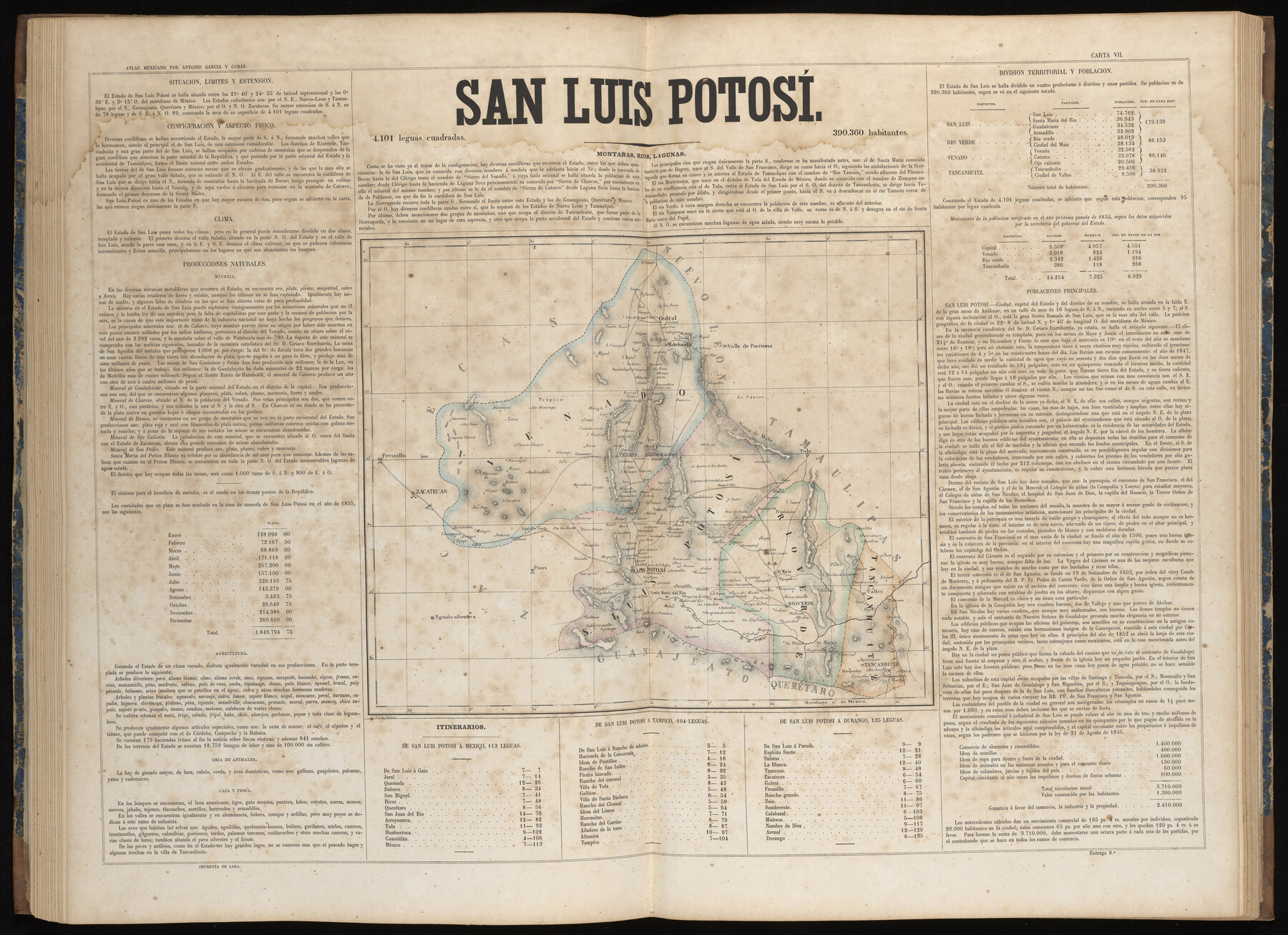
San Luis Potosi
-
Map/Doc
96999
-
Collection
General Map Collection
-
Object Dates
1858 (Publication Date)
-
People and Organizations
Antonio García y Cubas (Cartographer)
-
Subjects
Atlas Mexico
-
Height x Width
23.0 x 31.7 inches
58.4 x 80.5 cm
-
Medium
paper, etching/engraving/lithograph
-
Comments
Map 18 of 32 from "Atlas Geografico, Estadistico e Historico de la Republica Mexicana" (95689)
Related maps
Atlas Geográfico, Estadístico é Histórico de la República Mexicana

Atlas Geográfico, Estadístico é Histórico de la República Mexicana
Map/Doc 95689
Part of: General Map Collection
San Patricio County Rolled Sketch 25

Print $40.00
- Digital $50.00
San Patricio County Rolled Sketch 25
1925
Size 37.2 x 54.1 inches
Map/Doc 9887
Childress County Sketch File 16b

Print $6.00
- Digital $50.00
Childress County Sketch File 16b
1884
Size 12.6 x 8.1 inches
Map/Doc 18305
Starr County Sketch File 21

Print $52.00
- Digital $50.00
Starr County Sketch File 21
1912
Size 14.2 x 8.7 inches
Map/Doc 36889
Hunt County Working Sketch 1

Print $20.00
- Digital $50.00
Hunt County Working Sketch 1
Size 18.2 x 17.2 inches
Map/Doc 66348
Flight Mission No. DQN-5K, Frame 143, Calhoun County

Print $20.00
- Digital $50.00
Flight Mission No. DQN-5K, Frame 143, Calhoun County
1953
Size 18.8 x 22.3 inches
Map/Doc 84418

Galveston County NRC Article 33.136 Location Key Sheet

Print $20.00
- Digital $50.00
Galveston County NRC Article 33.136 Location Key Sheet
1994
Size 27.0 x 21.8 inches
Map/Doc 77016
Van Zandt County Working Sketch 14

Print $20.00
- Digital $50.00
Van Zandt County Working Sketch 14
1982
Size 13.2 x 11.5 inches
Map/Doc 72264
Flight Mission No. DAG-21K, Frame 83, Matagorda County

Print $20.00
- Digital $50.00
Flight Mission No. DAG-21K, Frame 83, Matagorda County
1952
Size 18.7 x 22.4 inches
Map/Doc 86412


Intracoastal Waterway, Houma, LA to Corpus Christi, TX

Print $20.00
- Digital $50.00
Intracoastal Waterway, Houma, LA to Corpus Christi, TX
Size 18.7 x 30.2 inches
Map/Doc 61908
You may also like
Mitchell County Sketch File 5

Print $20.00
- Digital $50.00
Mitchell County Sketch File 5
1906
Size 17.5 x 22.2 inches
Map/Doc 12095
Jefferson County Working Sketch 30a

Print $20.00
- Digital $50.00
Jefferson County Working Sketch 30a
1977
Size 17.8 x 21.2 inches
Map/Doc 66573
Etats-Unis de l'Amérique Septentrionale avec les Isles Royale, de Terre Neuve de St. Jean, L'Acadie &c.

Print $20.00
- Digital $50.00
Etats-Unis de l'Amérique Septentrionale avec les Isles Royale, de Terre Neuve de St. Jean, L'Acadie &c.
1785
Size 20.9 x 28.2 inches
Map/Doc 93679
Galveston County Rolled Sketch 39

Print $20.00
- Digital $50.00
Galveston County Rolled Sketch 39
Size 18.1 x 21.5 inches
Map/Doc 45207
Crane County Sketch File 19

Print $4.00
- Digital $50.00
Crane County Sketch File 19
1927
Size 11.4 x 8.8 inches
Map/Doc 19584
Montgomery County Working Sketch 74

Print $20.00
- Digital $50.00
Montgomery County Working Sketch 74
1981
Size 37.6 x 45.6 inches
Map/Doc 71181
Ellis County Sketch File 11

Print $40.00
- Digital $50.00
Ellis County Sketch File 11
1860
Size 12.6 x 16.2 inches
Map/Doc 21847
Ector County Rolled Sketch 13

Print $40.00
- Digital $50.00
Ector County Rolled Sketch 13
1957
Size 49.2 x 32.0 inches
Map/Doc 8841
International Railroad Map & Profile of the First Fifty Miles East of Brazos River

Print $40.00
- Digital $50.00
International Railroad Map & Profile of the First Fifty Miles East of Brazos River
1877
Size 19.5 x 84.9 inches
Map/Doc 64463
Platts [sic] of S. C. Robertson Surveys
![105, Platts [sic] of S. C. Robertson Surveys, General Map Collection](https://historictexasmaps.com/wmedia_w700/maps/105.tif.jpg)
Print $20.00
- Digital $50.00
Platts [sic] of S. C. Robertson Surveys
1841
Size 13.6 x 15.7 inches
Map/Doc 105
Flight Mission No. DQN-6K, Frame 72, Calhoun County

Print $20.00
- Digital $50.00
Flight Mission No. DQN-6K, Frame 72, Calhoun County
1953
Size 18.4 x 22.0 inches
Map/Doc 84444
Llano County Working Sketch 6

Print $20.00
- Digital $50.00
Llano County Working Sketch 6
1961
Size 15.8 x 20.8 inches
Map/Doc 70624