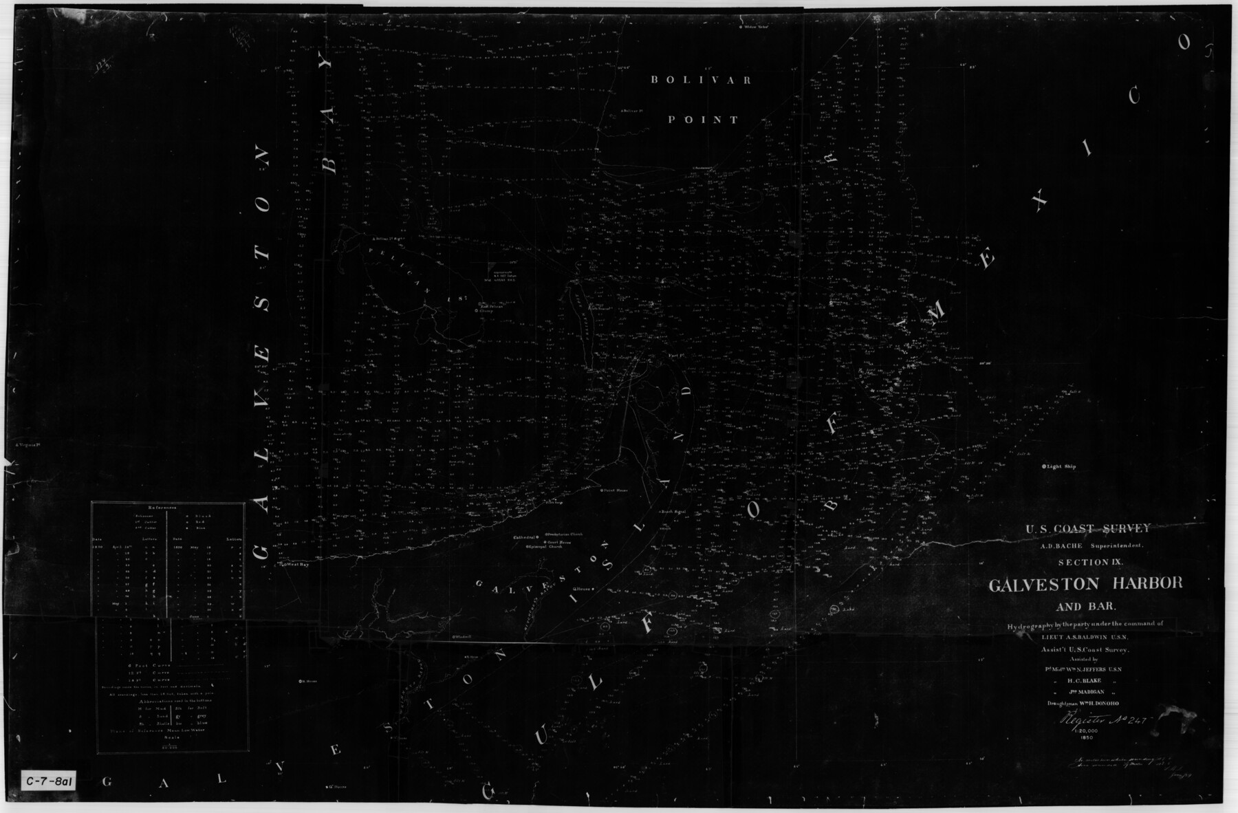
Section IX, Galveston Harbor and Bar
C-7-8a1
-
Map/Doc
69855
-
Collection
General Map Collection
-
Object Dates
1850 (Creation Date)
-
Counties
Galveston
-
Subjects
Nautical Charts
-
Height x Width
30.0 x 45.7 inches
76.2 x 116.1 cm
Part of: General Map Collection
Kimble County Working Sketch 64

Print $20.00
- Digital $50.00
Kimble County Working Sketch 64
1964
Size 15.1 x 16.9 inches
Map/Doc 70132
Burnet County Rolled Sketch 7

Print $20.00
- Digital $50.00
Burnet County Rolled Sketch 7
1987
Size 18.4 x 24.0 inches
Map/Doc 5357
Stonewall County Working Sketch 35

Print $20.00
- Digital $50.00
Stonewall County Working Sketch 35
1991
Size 41.1 x 33.0 inches
Map/Doc 62342
Mason County Sketch File 21A

Print $20.00
- Digital $50.00
Mason County Sketch File 21A
1932
Size 19.2 x 26.6 inches
Map/Doc 12037
Sutton County Rolled Sketch 69

Print $20.00
- Digital $50.00
Sutton County Rolled Sketch 69
Size 39.7 x 36.6 inches
Map/Doc 9981
Presidio County Rolled Sketch 6

Print $40.00
- Digital $50.00
Presidio County Rolled Sketch 6
1949
Size 56.8 x 32.2 inches
Map/Doc 9761
Gregg County Sketch File 1B

Print $4.00
- Digital $50.00
Gregg County Sketch File 1B
1848
Size 12.8 x 8.4 inches
Map/Doc 24538
Kimble County Sketch File 6

Print $4.00
- Digital $50.00
Kimble County Sketch File 6
Size 6.4 x 8.0 inches
Map/Doc 28918
Briscoe County Sketch File O

Print $40.00
- Digital $50.00
Briscoe County Sketch File O
Size 27.1 x 32.4 inches
Map/Doc 11013
Flight Mission No. CGI-4N, Frame 172, Cameron County

Print $20.00
- Digital $50.00
Flight Mission No. CGI-4N, Frame 172, Cameron County
1955
Size 18.5 x 22.3 inches
Map/Doc 84675
Reagan County Working Sketch 28

Print $40.00
- Digital $50.00
Reagan County Working Sketch 28
1963
Size 55.7 x 42.4 inches
Map/Doc 71870

You may also like
La Salle County Rolled Sketch 14B

Print $20.00
- Digital $50.00
La Salle County Rolled Sketch 14B
Size 20.7 x 23.0 inches
Map/Doc 6578
Map of subdivision of submerged land in the Gulf of Mexico fronting on Matagorda Island and Peninsula

Print $40.00
- Digital $50.00
Map of subdivision of submerged land in the Gulf of Mexico fronting on Matagorda Island and Peninsula
1940
Size 28.3 x 60.5 inches
Map/Doc 2928
Sutton County

Print $40.00
- Digital $50.00
Sutton County
1941
Size 43.9 x 56.1 inches
Map/Doc 73296
Brewster County Sketch File N-23

Print $6.00
- Digital $50.00
Brewster County Sketch File N-23
1951
Size 14.4 x 9.0 inches
Map/Doc 15697
Palo Pinto County

Print $20.00
- Digital $50.00
Palo Pinto County
1879
Size 24.8 x 18.4 inches
Map/Doc 3934
Stonewall County Rolled Sketch A and B

Print $20.00
- Digital $50.00
Stonewall County Rolled Sketch A and B
1886
Size 17.8 x 45.3 inches
Map/Doc 9957
McClennan County Robertson District East of the Brazos Milam District West of the Brazos

Print $20.00
- Digital $50.00
McClennan County Robertson District East of the Brazos Milam District West of the Brazos
1878
Size 21.0 x 23.4 inches
Map/Doc 3865
Reeves County Working Sketch 2

Print $20.00
- Digital $50.00
Reeves County Working Sketch 2
1903
Size 22.6 x 42.4 inches
Map/Doc 63444
North Sulphur River, Ben Franklin Sheet

Print $20.00
- Digital $50.00
North Sulphur River, Ben Franklin Sheet
1928
Size 14.2 x 30.0 inches
Map/Doc 78324
Dallam County Sketch File 1

Print $22.00
- Digital $50.00
Dallam County Sketch File 1
1885
Size 29.5 x 27.1 inches
Map/Doc 11277
Southern Pacific Transportation Company, Right of Way and Track Map, Beeville Branch

Print $40.00
- Digital $50.00
Southern Pacific Transportation Company, Right of Way and Track Map, Beeville Branch
Size 24.1 x 56.1 inches
Map/Doc 76163
Johnson County

Print $20.00
- Digital $50.00
Johnson County
1943
Size 43.3 x 40.2 inches
Map/Doc 95549