Angelina County Sketch File 28
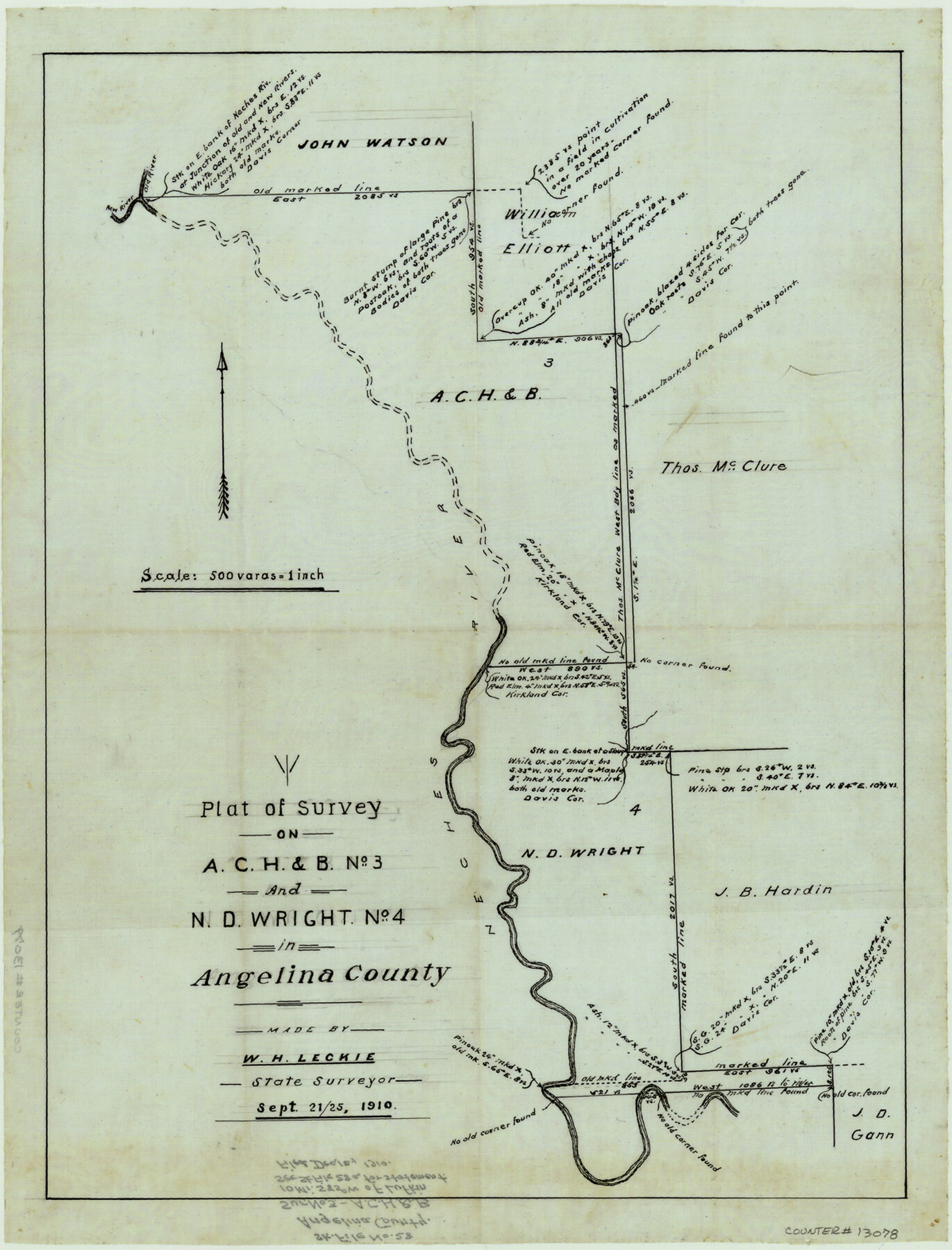
Plat of survey on A. C. H. & B. no. 3 and N.D. Wright no. 4 in Angelina County
-
Map/Doc
13078
-
Collection
General Map Collection
-
Object Dates
1910/9/25 (Creation Date)
1910/12/12 (File Date)
-
People and Organizations
W.H. Leckie (Surveyor/Engineer)
-
Counties
Angelina
-
Subjects
Surveying Sketch File
-
Height x Width
15.7 x 12.0 inches
39.9 x 30.5 cm
-
Medium
linen, manuscript
-
Scale
1" = 500 varas
-
Comments
See Angelina County Sketch File 28a (13080) for statement.
-
Features
Old River
New River
Neches River
Related maps
Angelina County Sketch File 28a

Print $14.00
- Digital $50.00
Angelina County Sketch File 28a
1910
Size 6.8 x 8.7 inches
Map/Doc 13080
Part of: General Map Collection
Uvalde County Working Sketch 17

Print $20.00
- Digital $50.00
Uvalde County Working Sketch 17
1947
Size 27.5 x 37.3 inches
Map/Doc 72087
Flight Mission No. BQR-5K, Frame 65, Brazoria County

Print $20.00
- Digital $50.00
Flight Mission No. BQR-5K, Frame 65, Brazoria County
1952
Size 18.8 x 22.5 inches
Map/Doc 84010
Dimmit County Working Sketch 46

Print $20.00
- Digital $50.00
Dimmit County Working Sketch 46
1980
Size 25.7 x 31.0 inches
Map/Doc 68707
Harris County Rolled Sketch T2

Print $20.00
- Digital $50.00
Harris County Rolled Sketch T2
1916
Size 26.8 x 23.2 inches
Map/Doc 6145
Pecos County Working Sketch 100

Print $20.00
- Digital $50.00
Pecos County Working Sketch 100
1970
Size 42.9 x 31.6 inches
Map/Doc 71573
Brazoria County Working Sketch 39

Print $40.00
- Digital $50.00
Brazoria County Working Sketch 39
1981
Size 74.6 x 44.1 inches
Map/Doc 67524
Galveston County Sketch File 18

Print $4.00
- Digital $50.00
Galveston County Sketch File 18
Size 5.5 x 8.0 inches
Map/Doc 23388

Pecos County Working Sketch 123

Print $20.00
- Digital $50.00
Pecos County Working Sketch 123
1973
Size 42.4 x 24.2 inches
Map/Doc 71596
Frio County Rolled Sketch 16

Print $20.00
- Digital $50.00
Frio County Rolled Sketch 16
1952
Size 38.4 x 40.7 inches
Map/Doc 8906
Fisher County Working Sketch 14

Print $20.00
- Digital $50.00
Fisher County Working Sketch 14
1957
Size 24.9 x 33.1 inches
Map/Doc 69148
Hutchinson County Rolled Sketch 8

Print $20.00
- Digital $50.00
Hutchinson County Rolled Sketch 8
Size 32.0 x 29.1 inches
Map/Doc 6279
You may also like
Travis County Appraisal District Plat Map 2_3215

Print $20.00
- Digital $50.00
Travis County Appraisal District Plat Map 2_3215
Size 21.5 x 26.4 inches
Map/Doc 94222
Harris County Working Sketch 5

Print $20.00
- Digital $50.00
Harris County Working Sketch 5
Size 35.1 x 28.0 inches
Map/Doc 65897
Jefferson County Rolled Sketch 46

Print $2.00
- Digital $50.00
Jefferson County Rolled Sketch 46
1969
Size 12.3 x 5.9 inches
Map/Doc 10198

Carte du Texas par M. Maris

Print $20.00
- Digital $50.00
Carte du Texas par M. Maris
1846
Size 19.3 x 17.2 inches
Map/Doc 2119
Bosque County Working Sketch 32

Print $20.00
- Digital $50.00
Bosque County Working Sketch 32
2014
Size 24.3 x 24.7 inches
Map/Doc 93687
Working Sketch in Gray County

Print $3.00
- Digital $50.00
Working Sketch in Gray County
1903
Size 10.9 x 15.5 inches
Map/Doc 90753
Map of Blocks A, B and C in Parmer County, Texas showing a portion of the C. F. L. & I. Co's. XIT Lands

Print $20.00
- Digital $50.00
Map of Blocks A, B and C in Parmer County, Texas showing a portion of the C. F. L. & I. Co's. XIT Lands
1905
Size 24.2 x 29.4 inches
Map/Doc 91611
Grimes County Working Sketch 13

Print $20.00
- Digital $50.00
Grimes County Working Sketch 13
1982
Size 39.4 x 47.7 inches
Map/Doc 63304
Newton County Sketch File 20a

Print $8.00
- Digital $50.00
Newton County Sketch File 20a
Size 3.7 x 8.8 inches
Map/Doc 32397
Cooke County Sketch File 9

Print $6.00
- Digital $50.00
Cooke County Sketch File 9
Size 8.2 x 10.5 inches
Map/Doc 19237
Marion County Working Sketch 9

Print $20.00
- Digital $50.00
Marion County Working Sketch 9
1940
Size 23.5 x 25.5 inches
Map/Doc 70784