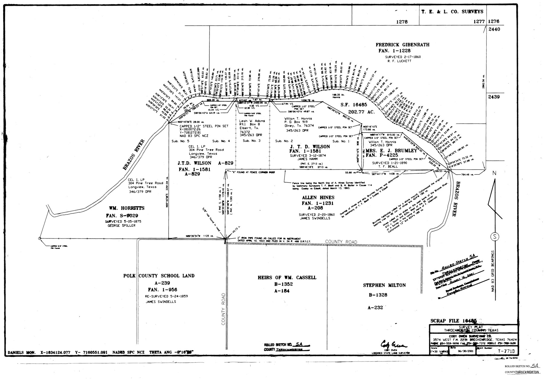
Throckmorton County Rolled Sketch 5A
[Survey plat - SF-16485]
-
Map/Doc
76406
-
Collection
General Map Collection
-
Object Dates
2001/6/30 (Creation Date)
2001/8/16 (File Date)
-
People and Organizations
Cody Owen (Surveyor/Engineer)
-
Counties
Throckmorton
-
Subjects
Surveying Rolled Sketch
-
Height x Width
25.2 x 36.0 inches
64.0 x 91.4 cm
-
Medium
mylar, print
-
Scale
1" = 30 varas
Part of: General Map Collection
Dawson County Sketch File 3

Print $20.00
- Digital $50.00
Dawson County Sketch File 3
Size 13.5 x 37.8 inches
Map/Doc 11290
Real County Sketch File 16

Print $20.00
- Digital $50.00
Real County Sketch File 16
1934
Size 23.1 x 22.1 inches
Map/Doc 12234
Knox County Sketch File 14

Print $12.00
- Digital $50.00
Knox County Sketch File 14
1892
Size 11.1 x 8.5 inches
Map/Doc 29235
Supreme Court of the United States, October Term, 1923, No. 15, Original - The State of Oklahoma, Complainant vs. The State of Texas, Defendant, The United States, Intervener; Report of the Boundary Commissioners

Print $20.00
- Digital $50.00
Supreme Court of the United States, October Term, 1923, No. 15, Original - The State of Oklahoma, Complainant vs. The State of Texas, Defendant, The United States, Intervener; Report of the Boundary Commissioners
1923
Size 46.4 x 33.4 inches
Map/Doc 75122
Johnson County Working Sketch 26

Print $20.00
- Digital $50.00
Johnson County Working Sketch 26
2005
Size 22.3 x 41.8 inches
Map/Doc 83574
Travis County Sketch File 18

Print $20.00
- Digital $50.00
Travis County Sketch File 18
1872
Size 24.2 x 25.4 inches
Map/Doc 12458
Sketch showing surveys on Harbor Island in Nueces County

Print $20.00
- Digital $50.00
Sketch showing surveys on Harbor Island in Nueces County
1978
Size 46.4 x 36.0 inches
Map/Doc 2020
Hall County Sketch File 5

Print $20.00
- Digital $50.00
Hall County Sketch File 5
1884
Size 18.9 x 24.1 inches
Map/Doc 11602
Presidio County Sketch File 111

Print $4.00
- Digital $50.00
Presidio County Sketch File 111
1885
Size 14.3 x 9.1 inches
Map/Doc 34824
Polk County Sketch File 34

Print $20.00
- Digital $50.00
Polk County Sketch File 34
Size 16.9 x 18.2 inches
Map/Doc 12194
Palo Pinto County Rolled Sketch 10

Print $20.00
- Digital $50.00
Palo Pinto County Rolled Sketch 10
1954
Size 35.4 x 34.1 inches
Map/Doc 9676
Austin County Working Sketch 8

Print $20.00
- Digital $50.00
Austin County Working Sketch 8
1992
Size 28.7 x 31.6 inches
Map/Doc 67249
You may also like
Dimmit County Working Sketch Graphic Index - sheet B

Print $40.00
- Digital $50.00
Dimmit County Working Sketch Graphic Index - sheet B
1976
Size 41.5 x 49.9 inches
Map/Doc 76525
A Geographically Correct County Map of States Traversed by the St. Louis, Iron Mountain & Southern Railway and its Connections

Print $20.00
- Digital $50.00
A Geographically Correct County Map of States Traversed by the St. Louis, Iron Mountain & Southern Railway and its Connections
1876
Size 18.6 x 15.9 inches
Map/Doc 95781
Connected Map of Austin's Colony

Print $20.00
- Digital $50.00
Connected Map of Austin's Colony
1892
Size 47.5 x 43.0 inches
Map/Doc 76074
Harris County Sketch File 5

Print $20.00
- Digital $50.00
Harris County Sketch File 5
1858
Size 22.0 x 15.0 inches
Map/Doc 11648
Culberson County Rolled Sketch 17

Print $20.00
- Digital $50.00
Culberson County Rolled Sketch 17
1904
Size 22.3 x 23.8 inches
Map/Doc 5649
Eastern and Central Texas, Prepared by Order of Maj. Gen. N.P. Banks. Major D.C. Houston, Chief of Engineers

Print $20.00
Eastern and Central Texas, Prepared by Order of Maj. Gen. N.P. Banks. Major D.C. Houston, Chief of Engineers
1864
Size 32.6 x 23.7 inches
Map/Doc 88596
Hutchinson County Working Sketch 35

Print $20.00
- Digital $50.00
Hutchinson County Working Sketch 35
1978
Size 27.0 x 22.3 inches
Map/Doc 66395
[I. &G. N. RR. Co. Block I along Pecos River and other Blocks to the West]
![89827, [I. &G. N. RR. Co. Block I along Pecos River and other Blocks to the West], Twichell Survey Records](https://historictexasmaps.com/wmedia_w700/maps/89827-1.tif.jpg)
Print $20.00
- Digital $50.00
[I. &G. N. RR. Co. Block I along Pecos River and other Blocks to the West]
Size 44.4 x 45.2 inches
Map/Doc 89827
Harris County Sketch File 57

Print $15.00
- Digital $50.00
Harris County Sketch File 57
1919
Size 8.8 x 7.7 inches
Map/Doc 25473
Falls County Sketch File 33

Print $4.00
- Digital $50.00
Falls County Sketch File 33
1873
Size 10.3 x 8.3 inches
Map/Doc 22441
Leon County Working Sketch 39

Print $20.00
- Digital $50.00
Leon County Working Sketch 39
1980
Size 35.1 x 42.2 inches
Map/Doc 70438
[Spade and Ellwood Lands in Lubbock and Hale Counties]
![91072, [Spade and Ellwood Lands in Lubbock and Hale Counties], Twichell Survey Records](https://historictexasmaps.com/wmedia_w700/maps/91072-1.tif.jpg)
Print $20.00
- Digital $50.00
[Spade and Ellwood Lands in Lubbock and Hale Counties]
Size 18.0 x 17.8 inches
Map/Doc 91072