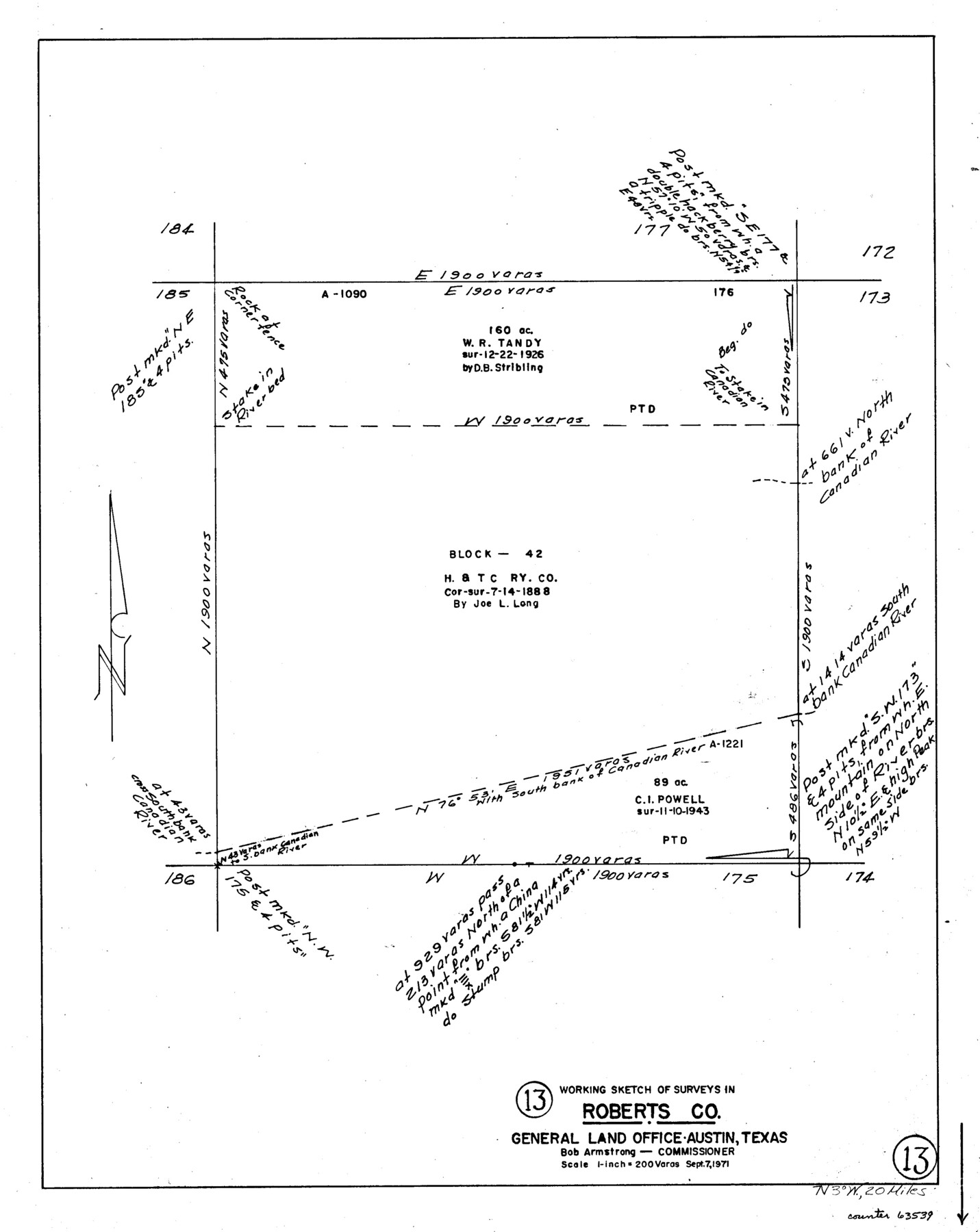
Roberts County Working Sketch 13
-
Map/Doc
63539
-
Collection
General Map Collection
-
Object Dates
9/7/1971 (Creation Date)
-
Counties
Roberts
-
Subjects
Surveying Working Sketch
-
Height x Width
20.2 x 16.0 inches
51.3 x 40.6 cm
-
Scale
1" = 200 varas
Part of: General Map Collection
Goliad County Sketch File 5

Print $6.00
- Digital $50.00
Goliad County Sketch File 5
Size 15.9 x 10.2 inches
Map/Doc 24218
Brazoria County Working Sketch 20

Print $40.00
- Digital $50.00
Brazoria County Working Sketch 20
1951
Size 50.3 x 42.9 inches
Map/Doc 67505
Menard County Boundary File 6

Print $6.00
- Digital $50.00
Menard County Boundary File 6
Size 11.2 x 8.7 inches
Map/Doc 57086
Leon County Sketch File 9

Print $4.00
- Digital $50.00
Leon County Sketch File 9
1863
Size 15.1 x 8.3 inches
Map/Doc 29726
Jeff Davis County Working Sketch 49

Print $20.00
- Digital $50.00
Jeff Davis County Working Sketch 49
2008
Size 38.0 x 35.7 inches
Map/Doc 88816

Marion County Sketch File 18

Print $77.00
- Digital $50.00
Marion County Sketch File 18
1913
Size 10.3 x 12.3 inches
Map/Doc 30590
Montgomery County Working Sketch 32

Print $20.00
- Digital $50.00
Montgomery County Working Sketch 32
1950
Size 32.8 x 32.8 inches
Map/Doc 71139
Sabine County Working Sketch 10

Print $20.00
- Digital $50.00
Sabine County Working Sketch 10
1925
Size 18.6 x 24.2 inches
Map/Doc 63681
Texas in 1840, or the Emigrant's Guide to the New Republic; being the result of observation, enquiry and travel in that beautiful country

Texas in 1840, or the Emigrant's Guide to the New Republic; being the result of observation, enquiry and travel in that beautiful country
1840
Map/Doc 97198
Flight Mission No. CRC-4R, Frame 153, Chambers County

Print $20.00
- Digital $50.00
Flight Mission No. CRC-4R, Frame 153, Chambers County
1956
Size 18.7 x 22.4 inches
Map/Doc 84916
Val Verde County Working Sketch 96

Print $20.00
- Digital $50.00
Val Verde County Working Sketch 96
1979
Size 38.9 x 36.9 inches
Map/Doc 72231
You may also like
Runnels County Working Sketch 14

Print $20.00
- Digital $50.00
Runnels County Working Sketch 14
1950
Size 28.4 x 26.8 inches
Map/Doc 63610
Throckmorton County Rolled Sketch 5

Print $20.00
- Digital $50.00
Throckmorton County Rolled Sketch 5
2001
Size 25.0 x 35.9 inches
Map/Doc 76405
Whitehead Second Addition, City of Lubbock

Print $20.00
- Digital $50.00
Whitehead Second Addition, City of Lubbock
1951
Size 14.1 x 24.0 inches
Map/Doc 92778
Padre Island National Seashore, Texas - Dependent Resurvey

Print $4.00
- Digital $50.00
Padre Island National Seashore, Texas - Dependent Resurvey
2001
Size 18.4 x 24.0 inches
Map/Doc 60551

Zavala County Sketch File B

Print $34.00
- Digital $50.00
Zavala County Sketch File B
1908
Size 13.5 x 8.9 inches
Map/Doc 41364
Texas City Channel, Texas, Channel and Turning Basin Dredging - Sheet 2

Print $20.00
- Digital $50.00
Texas City Channel, Texas, Channel and Turning Basin Dredging - Sheet 2
1958
Size 28.6 x 41.0 inches
Map/Doc 61832
Packery Channel

Print $20.00
- Digital $50.00
Packery Channel
1954
Size 16.7 x 19.9 inches
Map/Doc 3002
Galveston County Sketch File 67

Print $4.00
- Digital $50.00
Galveston County Sketch File 67
1988
Size 11.3 x 8.7 inches
Map/Doc 23782
McMullen County Sketch File 27a

Print $4.00
- Digital $50.00
McMullen County Sketch File 27a
Size 9.5 x 6.3 inches
Map/Doc 31390
Flight Mission No. DCL-5C, Frame 69, Kenedy County

Print $20.00
- Digital $50.00
Flight Mission No. DCL-5C, Frame 69, Kenedy County
1943
Size 18.5 x 22.3 inches
Map/Doc 85852
Fractional Township No. 7 South Range No. 6 East of the Indian Meridian, Indian Territory

Print $20.00
- Digital $50.00
Fractional Township No. 7 South Range No. 6 East of the Indian Meridian, Indian Territory
1898
Size 19.2 x 24.3 inches
Map/Doc 75211