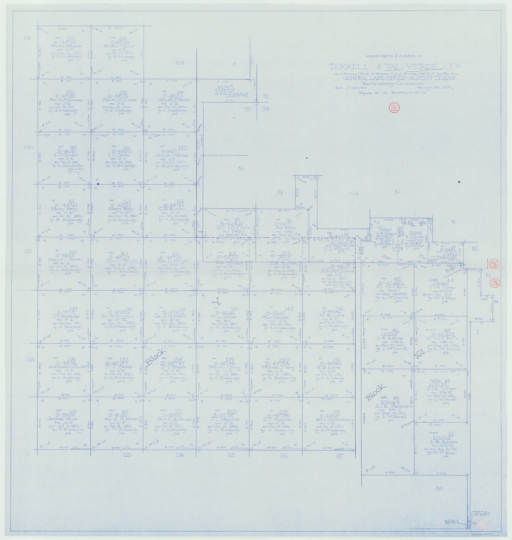
Val Verde County Working Sketch 96
-
Map/Doc
72231
-
Collection
General Map Collection
-
Object Dates
2/2/1979 (Creation Date)
-
People and Organizations
Joan Kilpatrick (Draftsman)
-
Counties
Val Verde Terrell
-
Subjects
Surveying Working Sketch
-
Height x Width
38.9 x 36.9 inches
98.8 x 93.7 cm
-
Scale
1" = 500 varas
Part of: General Map Collection
Flight Mission No. BRE-1P, Frame 94, Nueces County

Print $20.00
- Digital $50.00
Flight Mission No. BRE-1P, Frame 94, Nueces County
1956
Size 18.6 x 22.4 inches
Map/Doc 86665
Cass County Sketch File 23

Print $10.00
- Digital $50.00
Cass County Sketch File 23
1936
Size 14.1 x 8.6 inches
Map/Doc 17435
Clay County Working Sketch 14

Print $20.00
- Digital $50.00
Clay County Working Sketch 14
1984
Size 46.9 x 34.5 inches
Map/Doc 68037
Tarrant County

Print $20.00
- Digital $50.00
Tarrant County
1942
Size 46.5 x 37.1 inches
Map/Doc 77431
A General Map of the Middle British Colonies, in America. containing Virginia, Maryland, the Delaware Counties, Pennsylvania and New Jersey. With the addition of New York and of the Greatest Part of New England

Print $20.00
- Digital $50.00
A General Map of the Middle British Colonies, in America. containing Virginia, Maryland, the Delaware Counties, Pennsylvania and New Jersey. With the addition of New York and of the Greatest Part of New England
1776
Size 21.6 x 27.2 inches
Map/Doc 97402
Ward County Working Sketch 55

Print $20.00
- Digital $50.00
Ward County Working Sketch 55
1986
Size 30.0 x 36.8 inches
Map/Doc 72361
Flight Mission No. DAG-24K, Frame 136, Matagorda County

Print $20.00
- Digital $50.00
Flight Mission No. DAG-24K, Frame 136, Matagorda County
1953
Size 18.4 x 22.2 inches
Map/Doc 86554
Roberts County Working Sketch 10

Print $20.00
- Digital $50.00
Roberts County Working Sketch 10
1965
Size 23.0 x 29.0 inches
Map/Doc 63536
Lynn County Boundary File 7b

Print $8.00
- Digital $50.00
Lynn County Boundary File 7b
Size 11.3 x 8.6 inches
Map/Doc 56651
Bexar County State Real Property Sketch 6

Print $20.00
Bexar County State Real Property Sketch 6
2006
Size 22.2 x 33.1 inches
Map/Doc 96980
City of Austin, Texas - Height and Area adopted by City Council

Print $20.00
- Digital $50.00
City of Austin, Texas - Height and Area adopted by City Council
Size 42.5 x 28.6 inches
Map/Doc 95712

You may also like
Crockett County Rolled Sketch P1

Print $82.00
- Digital $50.00
Crockett County Rolled Sketch P1
1927
Size 10.3 x 15.9 inches
Map/Doc 44220
Webb County Sketch File 9a

Print $20.00
- Digital $50.00
Webb County Sketch File 9a
1930
Size 31.4 x 23.9 inches
Map/Doc 12619
Harris County Sketch File 56a

Print $54.00
- Digital $50.00
Harris County Sketch File 56a
1912
Size 9.0 x 7.9 inches
Map/Doc 25456
Burnet County Sketch File 14

Print $4.00
- Digital $50.00
Burnet County Sketch File 14
Size 15.1 x 8.9 inches
Map/Doc 16698
Medina County Rolled Sketch 7

Print $20.00
- Digital $50.00
Medina County Rolled Sketch 7
1966
Size 36.9 x 21.9 inches
Map/Doc 6741
Dawson County

Print $20.00
- Digital $50.00
Dawson County
1959
Size 43.5 x 35.1 inches
Map/Doc 77259

Presidio County Sketch File 112

Print $166.00
- Digital $50.00
Presidio County Sketch File 112
1983
Size 12.1 x 31.2 inches
Map/Doc 11727
Nueces County Rolled Sketch 99

Print $92.00
Nueces County Rolled Sketch 99
1985
Size 24.2 x 36.6 inches
Map/Doc 7060
Map of Kinney County

Print $20.00
- Digital $50.00
Map of Kinney County
1876
Size 24.8 x 37.8 inches
Map/Doc 3776
Stonewall County Sketch File 27

Print $8.00
- Digital $50.00
Stonewall County Sketch File 27
1955
Size 10.9 x 7.2 inches
Map/Doc 37296
