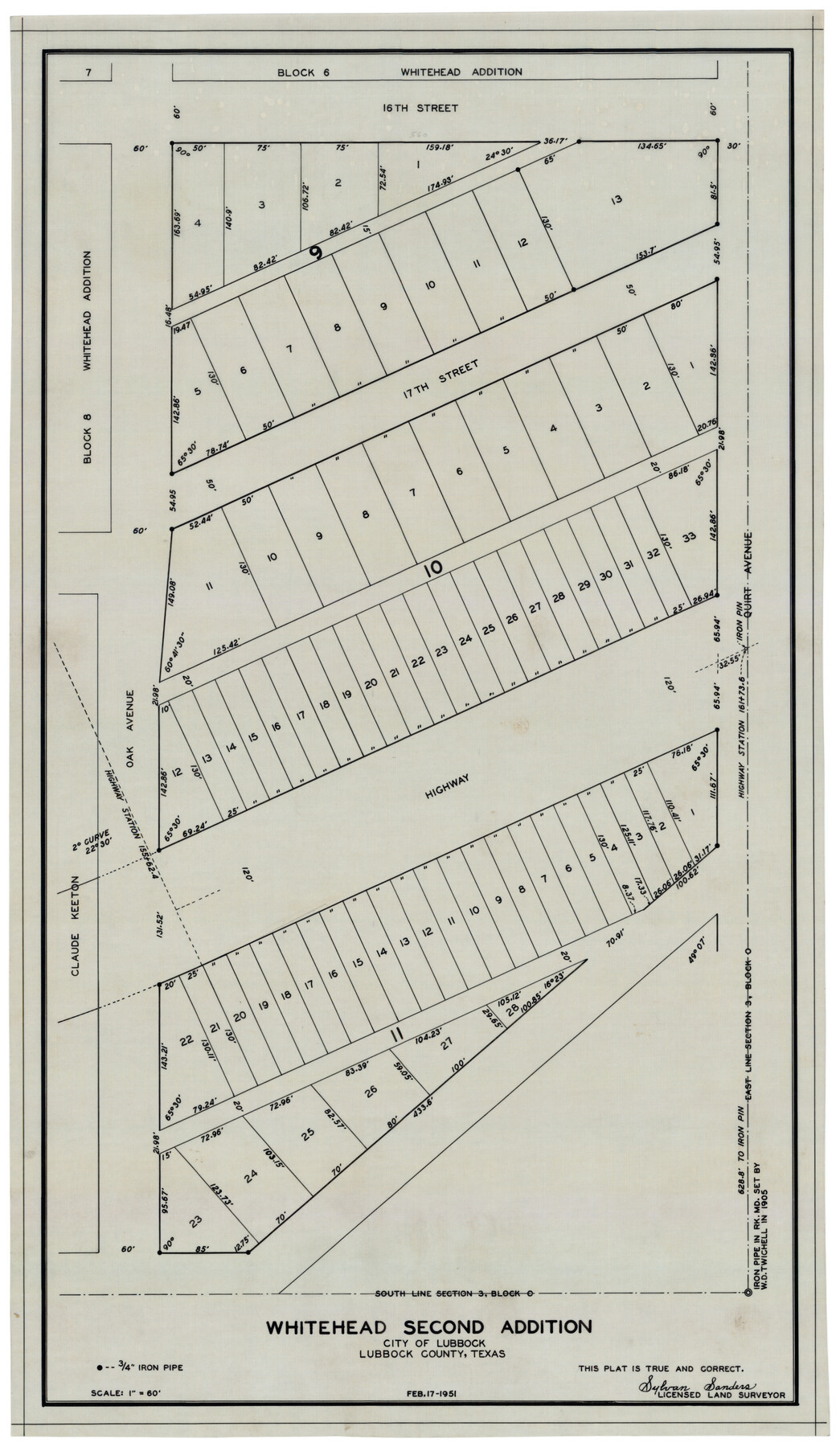
Whitehead Second Addition, City of Lubbock
-
Map/Doc
92778
-
Collection
Twichell Survey Records
-
Object Dates
2/17/1951 (Creation Date)
-
People and Organizations
Sylvan Sanders (Surveyor/Engineer)
-
Counties
Lubbock
-
Subjects
City
-
Height x Width
14.1 x 24.0 inches
35.8 x 61.0 cm
Part of: Twichell Survey Records
[Sketch of area just south of Levi Pruitt survey]
![91855, [Sketch of area just south of Levi Pruitt survey], Twichell Survey Records](https://historictexasmaps.com/wmedia_w700/maps/91855-1.tif.jpg)
Print $20.00
- Digital $50.00
[Sketch of area just south of Levi Pruitt survey]
1924
Size 17.0 x 17.8 inches
Map/Doc 91855
[Sketch Showing Blocks O18, P Mc, B10 and B11]
![93107, [Sketch Showing Blocks O18, P Mc, B10 and B11], Twichell Survey Records](https://historictexasmaps.com/wmedia_w700/maps/93107-1.tif.jpg)
Print $3.00
- Digital $50.00
[Sketch Showing Blocks O18, P Mc, B10 and B11]
Size 11.5 x 11.2 inches
Map/Doc 93107
Yates Pool, Pecos County, Texas

Print $20.00
- Digital $50.00
Yates Pool, Pecos County, Texas
1920
Size 17.5 x 15.7 inches
Map/Doc 91564
Blocks T1, T2, T3, S3, A, O5, and Capitol Leagues]
![91074, Blocks T1, T2, T3, S3, A, O5, and Capitol Leagues], Twichell Survey Records](https://historictexasmaps.com/wmedia_w700/maps/91074-1.tif.jpg)
Print $20.00
- Digital $50.00
Blocks T1, T2, T3, S3, A, O5, and Capitol Leagues]
Size 30.0 x 33.4 inches
Map/Doc 91074
Working Sketch in Caldwell County

Print $20.00
- Digital $50.00
Working Sketch in Caldwell County
1922
Size 41.1 x 44.4 inches
Map/Doc 89722
[Working Sketch in Martin County Showing Northwest Portion of County]
![91355, [Working Sketch in Martin County Showing Northwest Portion of County], Twichell Survey Records](https://historictexasmaps.com/wmedia_w700/maps/91355-1.tif.jpg)
Print $20.00
- Digital $50.00
[Working Sketch in Martin County Showing Northwest Portion of County]
1902
Size 17.1 x 36.0 inches
Map/Doc 91355
[Hutchinson County Resurveys South of the Canadian River]
![91166, [Hutchinson County Resurveys South of the Canadian River], Twichell Survey Records](https://historictexasmaps.com/wmedia_w700/maps/91166-1.tif.jpg)
Print $20.00
- Digital $50.00
[Hutchinson County Resurveys South of the Canadian River]
1920
Size 33.3 x 21.1 inches
Map/Doc 91166
[Sketch Showing Blocks O18 and B11]
![93108, [Sketch Showing Blocks O18 and B11], Twichell Survey Records](https://historictexasmaps.com/wmedia_w700/maps/93108-1.tif.jpg)
Print $3.00
- Digital $50.00
[Sketch Showing Blocks O18 and B11]
Size 15.5 x 11.9 inches
Map/Doc 93108
[Sketch of Public School Land Blocks A56, A57, B1, B2, B10, T&P 46]
![91978, [Sketch of Public School Land Blocks A56, A57, B1, B2, B10, T&P 46], Twichell Survey Records](https://historictexasmaps.com/wmedia_w700/maps/91978-1.tif.jpg)
Print $20.00
- Digital $50.00
[Sketch of Public School Land Blocks A56, A57, B1, B2, B10, T&P 46]
Size 20.0 x 23.2 inches
Map/Doc 91978
De Loache's Subdivision County School Leagues Hockley County, Texas

Print $20.00
- Digital $50.00
De Loache's Subdivision County School Leagues Hockley County, Texas
1924
Size 38.6 x 36.8 inches
Map/Doc 92235
[Nathaniel H. Cochran Survey and Vicinity]
![91495, [Nathaniel H. Cochran Survey and Vicinity], Twichell Survey Records](https://historictexasmaps.com/wmedia_w700/maps/91495-1.tif.jpg)
Print $20.00
- Digital $50.00
[Nathaniel H. Cochran Survey and Vicinity]
Size 26.4 x 19.0 inches
Map/Doc 91495
[H. & T. C. RR. Company, Block 47, Sections 47- 56 Corrected]
![91412, [H. & T. C. RR. Company, Block 47, Sections 47- 56 Corrected], Twichell Survey Records](https://historictexasmaps.com/wmedia_w700/maps/91412-1.tif.jpg)
Print $2.00
- Digital $50.00
[H. & T. C. RR. Company, Block 47, Sections 47- 56 Corrected]
Size 11.6 x 9.2 inches
Map/Doc 91412
You may also like
Flight Mission No. CUG-2P, Frame 69, Kleberg County

Print $20.00
- Digital $50.00
Flight Mission No. CUG-2P, Frame 69, Kleberg County
1956
Size 18.4 x 22.2 inches
Map/Doc 86206
Hays County Working Sketch 2

Print $20.00
- Digital $50.00
Hays County Working Sketch 2
1920
Size 26.1 x 27.1 inches
Map/Doc 66076
Henderson County Working Sketch 4

Print $20.00
- Digital $50.00
Henderson County Working Sketch 4
1918
Size 21.2 x 16.0 inches
Map/Doc 66137
Crockett County Sketch File 85

Print $6.00
- Digital $50.00
Crockett County Sketch File 85
1952
Size 33.7 x 31.2 inches
Map/Doc 10345
Wise County Sketch File 40

Print $4.00
- Digital $50.00
Wise County Sketch File 40
1875
Size 8.0 x 10.6 inches
Map/Doc 40597
Cameron County Rolled Sketch 20D

Print $20.00
- Digital $50.00
Cameron County Rolled Sketch 20D
Size 14.3 x 13.9 inches
Map/Doc 5477
Goliad County Sketch File 21

Print $10.00
- Digital $50.00
Goliad County Sketch File 21
1855
Size 12.0 x 7.9 inches
Map/Doc 24284
Van Zandt County Working Sketch 19

Print $20.00
- Digital $50.00
Van Zandt County Working Sketch 19
Size 43.3 x 32.8 inches
Map/Doc 72269
Oldham County Working Sketch 10

Print $20.00
- Digital $50.00
Oldham County Working Sketch 10
1983
Size 29.6 x 44.3 inches
Map/Doc 71332
Bee County Boundary File 2

Print $10.00
- Digital $50.00
Bee County Boundary File 2
Size 8.8 x 6.8 inches
Map/Doc 50435
Crockett County Working Sketch 62

Print $40.00
- Digital $50.00
Crockett County Working Sketch 62
1956
Size 121.8 x 37.1 inches
Map/Doc 68395
Hunt County Working Sketch 5

Print $20.00
- Digital $50.00
Hunt County Working Sketch 5
1942
Size 23.8 x 20.2 inches
Map/Doc 66352