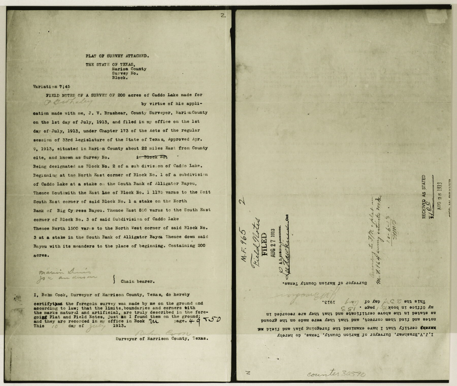
Marion County Sketch File 18
[Photostats of multiple Mineral File field notes and sketches]
-
Map/Doc
30590
-
Collection
General Map Collection
-
Object Dates
1913 (Creation Date)
-
People and Organizations
J.V. Brashear (Surveyor/Engineer)
Marion Sims (Chainman/Field Personnel)
Joe Anderson (Chainman/Field Personnel)
Behn Cook (Surveyor/Engineer)
Perry Thompson (Surveyor/Engineer)
H.F. Oney (Chainman/Field Personnel)
Tommy Haynes (Chainman/Field Personnel)
-
Counties
Marion
-
Subjects
Surveying Sketch File
-
Height x Width
10.3 x 12.3 inches
26.2 x 31.2 cm
-
Medium
photostat
-
Features
Caddo Lake
Alligator Bayou
Big Cypress Bayou
Clinton Lake
Caddo Lake Subdivision
Tar Island
Part of: General Map Collection
Maps of Gulf Intracoastal Waterway, Texas - Sabine River to the Rio Grande and connecting waterways including ship channels

Print $20.00
- Digital $50.00
Maps of Gulf Intracoastal Waterway, Texas - Sabine River to the Rio Grande and connecting waterways including ship channels
1966
Size 14.6 x 22.3 inches
Map/Doc 61962
Armstrong County Rolled Sketch 4

Print $40.00
- Digital $50.00
Armstrong County Rolled Sketch 4
1876
Size 37.8 x 70.8 inches
Map/Doc 8426
Harris County Working Sketch 129

Print $20.00
- Digital $50.00
Harris County Working Sketch 129
2014
Size 24.2 x 19.1 inches
Map/Doc 93711
Outer Continental Shelf Leasing Maps (Texas Offshore Operations)

Print $20.00
- Digital $50.00
Outer Continental Shelf Leasing Maps (Texas Offshore Operations)
Size 17.3 x 16.7 inches
Map/Doc 75841
Henderson County Rolled Sketch 11

Print $20.00
- Digital $50.00
Henderson County Rolled Sketch 11
1915
Size 29.5 x 42.5 inches
Map/Doc 75960
Menard County Working Sketch 11

Print $20.00
- Digital $50.00
Menard County Working Sketch 11
1939
Size 23.1 x 24.9 inches
Map/Doc 70958
[Map of Texas and Indian Territory]
![93757, [Map of Texas and Indian Territory], General Map Collection](https://historictexasmaps.com/wmedia_w700/maps/93757-1.tif.jpg)
Print $20.00
- Digital $50.00
[Map of Texas and Indian Territory]
1878
Size 26.2 x 20.1 inches
Map/Doc 93757
Van Zandt County Working Sketch 4

Print $20.00
- Digital $50.00
Van Zandt County Working Sketch 4
1929
Size 16.3 x 26.8 inches
Map/Doc 72253
Nolan County Working Sketch 10

Print $40.00
- Digital $50.00
Nolan County Working Sketch 10
1971
Size 78.9 x 37.0 inches
Map/Doc 71301

Bandera County Sketch File 27

Print $40.00
- Digital $50.00
Bandera County Sketch File 27
1930
Size 17.1 x 12.4 inches
Map/Doc 14019
Abandoned and Canceled Surveys - Volume 2 of 3, Counties E-K

Abandoned and Canceled Surveys - Volume 2 of 3, Counties E-K
Map/Doc 83249
You may also like
Lynn County Sketch File 13

Print $18.00
- Digital $50.00
Lynn County Sketch File 13
1903
Size 10.6 x 8.1 inches
Map/Doc 30482
Terry County Sketch File 3

Print $20.00
- Digital $50.00
Terry County Sketch File 3
1948
Size 16.2 x 39.0 inches
Map/Doc 10390
Map of Texas with population and location of principal towns and cities, according to latest reliable statistics

Print $20.00
- Digital $50.00
Map of Texas with population and location of principal towns and cities, according to latest reliable statistics
1906
Size 18.9 x 22.4 inches
Map/Doc 95869
Tarrant County

Print $40.00
- Digital $50.00
Tarrant County
1942
Size 48.3 x 38.0 inches
Map/Doc 95649
Flight Mission No. BRA-3M, Frame 123, Jefferson County

Print $20.00
- Digital $50.00
Flight Mission No. BRA-3M, Frame 123, Jefferson County
1953
Size 18.5 x 21.7 inches
Map/Doc 85397
Sutton County Sketch File 22

Print $4.00
- Digital $50.00
Sutton County Sketch File 22
Size 14.2 x 8.5 inches
Map/Doc 37459
Fisher County Sketch File 2

Print $2.00
- Digital $50.00
Fisher County Sketch File 2
1885
Size 12.4 x 7.5 inches
Map/Doc 22548
San Antonio del Encinal as Corrected

Print $20.00
- Digital $50.00
San Antonio del Encinal as Corrected
1916
Size 31.2 x 31.5 inches
Map/Doc 10757
Map Showing Survey of Navasota River Bed in Limestone County Texas Located North of Houston and Texas Central Railroad Bridge

Print $40.00
- Digital $50.00
Map Showing Survey of Navasota River Bed in Limestone County Texas Located North of Houston and Texas Central Railroad Bridge
1921
Size 68.0 x 42.5 inches
Map/Doc 65347

Lavaca County Working Sketch 18

Print $20.00
- Digital $50.00
Lavaca County Working Sketch 18
1979
Size 37.0 x 20.3 inches
Map/Doc 70371
[Kent County Block 4, Sections 33 and 46, Block 97, Sections 771 and 772]
![92192, [Kent County Block 4, Sections 33 and 46, Block 97, Sections 771 and 772], Twichell Survey Records](https://historictexasmaps.com/wmedia_w700/maps/92192-1.tif.jpg)
Print $2.00
- Digital $50.00
[Kent County Block 4, Sections 33 and 46, Block 97, Sections 771 and 772]
1951
Size 8.7 x 15.6 inches
Map/Doc 92192